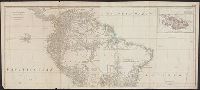
Also appeared in Kitchin's General atlas describing the whole universe. London : Printed for Robert Sayer, [1780]., Includes descriptive notes and text "Division of South America with a summary account of its trade," and large ornamental cartouche., Inset map: Chart of the Falkland's Islands : named by the French Malouine Islands, and discovered by Hawkins in the year 1595. Scale [ca. 1:2,000,000]., Prime meridian: Ferro., Relief shown pictorially; depths by soundings., Sheets measures 54 x 122.7 cm., and Sheets mounted together to form 2 sheets.
Publisher:
Printed for Robert Sayer,
Subject (Geographic):
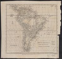
Falkland Islands--Maps--Early works to 1800 and South America--Maps--Early works to 1800
Subject (Name):
Anville, Jean Baptiste Bourguignon d', 1697-1782, Kitchin, Thomas, d. 1784, and Kitchin, Thomas, d. 1784. General atlas describing the whole universe
Both sheets backed with paper., Includes text and historical notes., Inset: Chart of Falkland Islands named by the French Malouine Islands and discovered by Hawkins in the year 1593., Outline color., Prime meridian: Ferro., Relief sh, and Watermarks on both sheets.
Publisher:
Sayer and Bennett,
Subject (Geographic):
Falkland Islands--Maps--Early works to 1800 and South America--Maps--Early works to 1800
London magazine, or, Gentleman's monthly intellegencer. v. 24. July 1755.
Description:
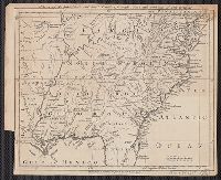
Appears in: London magazine, or, Gentleman's monthly intelligencer. (July 1755) v.24, p. 312., Covers also part of Pennsylvania, Delaware, Louisiana, and Arkansas., Hand col. Sheet measures 64.3 x 54.8 cm. Ms. no.: 15. Cross Collection no. 184., Prime meridian: London., Relief shown by landform drawings., and Shows names of English settlements, Native territories, drainage, and other points of interest.
Publisher:
Printed for R. Baldwin ...,
Subject (Geographic):
Maryland--Maps--Early works to 1800, New Jersey--Maps--Early works to 1800, and South Atlantic States--Maps--Early works to 1800
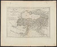
America Septentrionalis., Sir Charles Wager's engagement with the fleet of Spanish men of war and galeons off of Cartagena., and Sr. Charles Wager's engagement with the fleet of Spanish men of war and galeons off of Cartagena.
Description:
"C. Lemprière, inv. & del., B. Baron, sculp." cf. plate 17., "London engraved by Willm. Henry Toms, 1733 " cf. plate 20., Accompanied by text: The contents of each sheet of the twenty plates of Mr. Popple's Map of America. 25 cm., Cross Collection no. 313., First issued in 1732., Includes 22 insets, ill., and text., Includes 4 views, 18 insets, view of "Sr. Charles Wager's engagement with the fleet of Spanish men of war ...," and descriptive notes., Relief shown pictorially. Depths shown by soundings., Sheet 18: "Sr. Charles Wager's engagement ..." Sheet measures 53.4 x 72.0 cm., Title in top margin of key map: America Septentrionalis., and Title taken from plate 20.
Publisher:
Sold by S. Harding ... and by W.H. Toms, engraver ...,
Subject (Geographic):
Great Britain--Colonies--America--Maps--Early works to 1800 and North America--Maps--Early works to 1800
Subject (Name):
Baron, Bernard, 1696-1762, Harding, S., fl. 1724-1741, Lemprière, Clement, and Toms, W. H. (William Henry), approximately 1700-approximately 1750
According to Sellers and Van Ee, this map is the 2nd state., At lower margin "London, printed for R. Sayer & J. Bennett, map & sea chartseller, no. 53, Fleet Street, as the act directs, Augst. 17th 1776., Includes a list of British colonies and territories., and Relief shown pictorially.
Publisher:
[Printed and sold by R. Sayer and J. Bennett, map and print seller, no. 53, Fleet St. 1776]
Subject (Geographic):
North America--Maps--Early works to 1800
Subject (Name):
Carver, Jonathan, 1710-1780, Jefferys, Thomas, d. 1771. American atlas, and Robert Sayer and John Bennett (Firm)