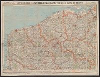
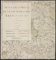
Germany. Heer. Abteilung für Kriegskarten- und Vermessungswesen. IV. Mil.-Geo
Published / Created:
1942
Call Number:
32 M312 1942
Container / Volume:
BRBL_00052
Image Count:
14
Resource Type:
Maps, Atlases & Globes
Alternative Title:
England 1:10 000 ; GB 4, BB 12e, 12f, 12g, 12h, 12i, 12k, 12l, 12m, 12n, 12o, 12p, 12q, 12r, 12s and Stadtplan von Manchester mit Mil.-Geo.-Eintragungen
Description:
"Militärgeogr. Angaben nach den bis zum 15. III. 1942 vorhandenen Unterlagen.", Relief shown by contours, hachures, and spot heights., and Shows features of military interest.
Publisher:
Generalstab des Heeres, Abteilung für Kriegskarten- u. Vermessungswesen (IV Mil.-Geo.),
"To accompany the Commissioner's joint report dated November 26, 1951. Upon the establishment of the boundary from Tongass Passage to Mount St. Elias in accordance with the convention of January 24, 1903, the award of the tribunal, appointed under the convention signed at London October 20, 1903 ..."
Publisher:
U.S. G.P.O.,
Subject (Geographic):
Alaska--Boundaries--Canada--Maps, Canada--Boundaries--United States--Maps, and United States--Boundaries--Canada--Maps
Fire insurance map, colored to show building construction, property boundaries and house and block numbers.
Alternative Title:
Dover, Del., Dover, Delaware, and June 1919, Dover, Del.
Description:
"15 sheets (2729).", Coordinates not present on map and are approximated., Includes index to streets and buildings., Sheet 1 includes key to building colors and other features of construction, water facilities and fire department, index map for the adjoining sheets., and Stamps on sheet 1: CLF 33650; Sep. 9, 1919.
Publisher:
Sanborn Map Company,
Subject (Geographic):
Dover (Del.)--Maps.
Subject (Topic):
Fire risk assessment--Delaware--Dover--Maps. and Real property--Delaware--Dover--Maps.
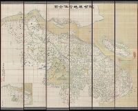
Includes 5 insets, var. scales: Hypsometrical and bathymetrical chart -- Political division of the Japanese Empire -- Chishima (Kurile Islands) -- [Taiwan and Ryūkyū Islands] -- Ogasawa-Jima (Bonin Islands), Ka and Relief shown by contours and spot heights.
Publisher:
Tōyōdō,
Subject (Geographic):
Japan--Administrative and political divisions--Maps, Japan--Maps, and Taiwan--Maps
Subject (Name):
Matsudaira, N, Suzuki, Kiyotada, and Togawa, Tametsugu
Fire insurance map, colored to show building construction, property boundaries and house and block numbers.
Alternative Title:
Milford, Del., Milford, Delaware, and Nov. 1919, Milford, Del.
Description:
"15 sheets (2932).", Coordinates not present on map and are approximated., Includes index to streets and buildings., Sheet 1 includes key to building colors and other features of construction, water facilities and fire department, index map for the adjoining sheets., and Stamps below title: CLF 33891; Feb. 13, 1920.
Publisher:
Sanborn Map Company,
Subject (Geographic):
Milford (Del.)--Maps.
Subject (Topic):
Fire risk assessment--Delaware--Milford--Maps. and Real property--Delaware--Milford--Maps.
Contents: The environs of London, reduced from an actual survey, in 16 sheets, by the late John Rocque ... with new improvements to the year 1763. - An exact survey of the city's of London, Westminster, ye borough of Southwark and the country near ten mil
Carte topographique de France de l'Etat-Major., Etat-Major carte de France., and Etat-Major nouvelle carte de France.
Description:
Imperfect: sheets 39 and 126-150 wanting; copies of sheets 131, 132, 141-144 and copy 2 of sheet 214 trimmed to neat line. Sheets dissected and m, Multiple copies of some sheets., and Some sheets imprinted "levée par les Officiers du Corps Royal d'Etat-Major."
Carte topographique des villes de Londres, Westminster, et bourg de Southwark et de leurs environs., Exact survey of the cities of London and Westminster, the borough of Southwark and the country near ten miles round, and Urbium maxime insignium Londini et Westmonasterii nec non municipii Sudovercencis, regionumque ad decem quasi milliaria circumjacentium.
Description:
"Publish'd 29th of April ... ", No. 3 of 7 maps bound together in a vol. with hand-lettered dust jacket with ms. title, "Rocque's map of London, 1746,"and autograph of Ralph Hodgson., and Relief shown by shading.
Publisher:
John Rocque,
Subject (Geographic):
London (England)--Maps--Early works to 1800.
Subject (Name):
Hodgson, Ralph,--1871-1962--Autograph., Parr, Richard, fl. 1723-1751., and Pratt, W.
Atlas accompanying volumes I & IV, Geological survey of Wisconsin., Atlas accompanying volumes I and IV, Geological survey of Wisconsin., Geology of Wisconsin, survey of 1873-1879., and Wisconsin geological survey.
Description:
Cover title: Atlas accompanying volumes I & IV, Geological survey of Wisconsin., Includes index., Reissue of selected plates originally published as Atlas of the geological survey of Wisconsin, which accompanied Geology of Wisconsin, survey of 1873-1879., and Running title: Wisconsin geological survey.
Publisher:
Milwaukee Litho. & Engr. Co.,
Subject (Geographic):
Wisconsin--Maps
Subject (Name):
Chamberlin, Thomas C. (Thomas Chrowder), 1843-1928, Irving, R. D, and Strong, Moses McCure
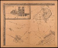
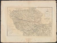
Grand plan de Paris et de ses environs, Paris et ses environs., Réproductions d'anciens plans de Paris, and Réproductions d'anciens plans de Paris ; [7].
Description:
"En vente, chez le sieur de Richesource, en place Daufine, à la Renomé. Publiée en 9 feuilles, accompagné d'une notice de M.A. Bonnardot"--Cover., "Gravé par François de La Pointe.", Accompanied by text: Grand plan de Jouvin de Rochefort, publié vers 1690 : extrait des Etudes archéologiques sur les anciens plans de Paris / Alfred Bonnardot., Cover title., Facsimile., Includes text: Grand plan de Jouvin de Rochefort, retouché en 1714 : extrait des Etudes archéologiques sur les anciens plans de Paris / Alfred Bonnardot., Includes view "Nostre Dame"., Inset map: Paris et ses environs., and Original scale information: "seize cens pas communs" ; "deux lieues communes de France"
Publisher:
A. Taride,
Subject (Geographic):
France--Paris, France--Paris Region, Paris (France)--Maps--Early works to 1800--Facsimiles., and Paris Region (France)--Maps.
Subject (Name):
Bonnardot, A. (Alfred). Grand plan de Jouvin de Rochefort., Cartes Taride (Firm), and La Pointe, François de.
Accompanied by cover sheet with variant title: Geologis, Relief shown by contours and spot heights., Sheets 3, 4, and 6 thru 15 are map sheets. Geological cross-sections on sheets 1, 2, and 5; title and legend on sheet 16., and Title from title sheet (Blatt 16).
Publisher:
Alfred Hölder,
Subject (Topic):
Coal mines and mining--Czech Republic--Duchcov Region--Maps, Coal mines and mining--Czech Republic--Most Region--Maps, Coal mines and mining--Czech Republic--Teplice Region--Maps, and Mining geology--Czech Republic--Duchcov Re
(from title page) The first beginning in Scotland & one sheere in England, Northumberland, & so to New-castle -- The second hath his head at New-castle & extendenth it selfe, all Durham, Westmoreland, Cumberland, Yorkeshire, Lancashire & part of Lincoln Shire -- The third hath Norfolke, Suffolke, Cambridge, Bedford, Hartford, Buckingham, Oxford, Northampton, Warwicke, Huntington, Lecester & Rutland, parte of Lincolne, Nottingham, Darby, Glocester, Barkeshire & Essex -- The fourth map runnes itselfe all Shropshire, Cheshire, Stafford, Woster, Heriford, most of Wales, Anglesey & part of Pembroke Shire -- The fift map, houldeth the south of Wales & Gloster, Somerset, Dorset, Deuon & Cornwall, part of Wiltshire -- The sixth mappe containes Kent, Southsex, Surrey, Middlesex, Barke, & Hampshire, part of Essex & Wiltshire, the small prikes boundeth euery shire and the dubell lines sheweth the rodes from place to place., Also known as the "Quartermaster's map"; see R.W. Shirley's Early printed maps of the British Isles, page 149., Hollar statement follows imprint on title page., Manuscript annotation on inside front cover. With metal clasps., and The title page is engraved.
Subject (Geographic):
England--Maps--Early works to 1800. and Wales--Maps--Early works to 1800.
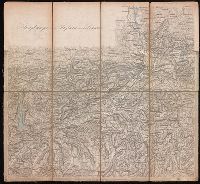
Relief shown by hachures., Sheets dated 1870 to 1874., Sheets dissected and mounted on linen. Stamp on verso of maps: Karpinski-von Wieser Map Collection. Seven sheets with labels and manuscript titles on verso., and Title supplied by cataloger.
Publisher:
[publisher not identified],
Subject (Geographic):
Tyrol (Austria)--Maps.
Subject (Name):
Karpinski, Louis Charles,--1878-1956--Ownership., Karpinski-von Wieser Map Collection., and Wieser, Franz,--Ritter von,--1848-1923--Ownership.
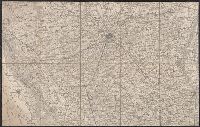
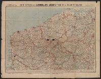
Carte routière pour automobilistes et cyclistes, Carte Taride, Cartes Taride pour automobilistes et cyclistes, and Nouvelle carte de France à l'usage des cyclistes et automobilistes
Description:
Also shows adjacent areas of Germany, Belgium, the Netherlands, Luxembourg, Switzerland, Italy, and Spain., Coverage complete in 34 sheets. Copy 3 incomplete., Each sheet separately numbered and titled: e.g., no. 3, Environs de Paris, section nord-est ; no. 27, Les bords du Rhin, Mayence à Strasbourg., Relief shown by shading and spot heights., and Some sheets dated in lower right corner, e.g., 5-18.
Engravers: Emanuel Bowen, C. Moore, and G. Child., From Jean-Baptiste Du Halde's Description géographique, historique, chronologique, politique, et physique de l'empire de la Chine (English edition, 1738)., From maps originally drawn in 1709-1710 by Jean Baptiste, Pierre Jartoux, Xavier Ehrenbert Fridelli, and Guillaume Bonjour., Prime meridians: Paris and Peking [Beijing]., Relief shown pictorially., and Watermarks.
Publisher:
[T. Gardner for Edward Cave],
Subject (Geographic):
Asia, Central--Maps--Early works to 1800.
Subject (Name):
Bonjour, Guillaume, 1670-1714, cartographer., Bowen, Emanuel, 1693 or 1694-1767, engraver., Child, G., engraver., and Du Halde, J.-B. (Jean-Baptiste), 1674-1743. Description géographique, historique, chronologique, politique,
"This survey was begun by Mr. Ogilby, and finished & humbly dedicated by Wm. Morgan.", Alternate title: A prospect of London and Westminster., Cadastral map., Facsimile., and Includes "A prospect of London and Westminster taken at several stations to the southwar
Publisher:
London Topographical Society,
Subject (Geographic):
London (England)--Aerial views--Early works to 1800--Facsimiles, London (England)--Maps--Early works to 1800--Facsimiles, and Westminster (London, England)--Aerial views--Early works to 1800--Facsimiles
Subject (Name):
Lea, Philip, active 1683-1700, London Topographical Society, Morden, Robert, approximately 1650-1703, and Ogilby, John, 1600-1676
Includes text, 2 indexed lists of churches, 12 coats of "The armes of the right worll. companies of the honorable cyty of London," illus. of "S. Peters, Westminster" and "S. Pauls, London," and diagr. of "Genealogia Bruti fundatoris vrbis Londini." and Title
Publisher:
London Topographical Society,
Subject (Geographic):
London (England)--Aerial views--Early works to 1800--Facsimiles, Southwark (London, England)--Aerial views--Early works to 1800--Facsimiles, and Westminster (London, England)--Aerial views--Early works to 1800--Facsimiles
Subject (Name):
Faithorne, William, 1616-1691 and London Topographical Society
Veue et perspective de la ville de Londre, Westminster et Parc St. Jacques and View of London and Westminster by John Kip, circa 1710-1720
Description:
"To Her Royal Highness Wilhelmina Carolina, the most illustrious Princess of Wales, this prospect of London, Westminster & St. James's Park is most humbly dedicated by John Kip.", In lower margin: Key to selected buildings or places of interest,, and Panorama.
Publisher:
London Topographical Society,
Subject (Geographic):
London (England)--Pictorial works--Early works to 1800--Facsimiles
At the beginning of the Ch'ing Dynasty (1644), the island became a defense against remnant Ming forces that had fled to Taiwan. During the second Opium War, Hai-Ta'n was occupied by British and French forces.
Publisher:
[publisher not identified],
Subject (Geographic):
Haitan Dao (China)--Maps.
Subject (Topic):
Chinese rare maps. and Islands--China--Fujian Sheng--Maps.
Manuscript number on verso of sheets: 2170. and Watermarks.
Subject (Name):
Cusani, Ferdinand and Ferrari, Carlo Francisco
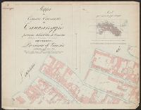
Subject (Topic):
Land tenure--Italy--Milan--Maps--Early works to 1800., Real property--Italy--Milan--Maps--Early works to 1800., and Water-supply--Italy--Milan--Maps--Early works to 1800.
Altitudes given in feet., Contours at 200 feet vertical intervals., Copy 2: Includes sheets 1, 2A, 3, 4A, 6A, 7A, 9A (two copies), 10-11, and 12A, with various corrections between 1928 and 1930., and Diagram showing adjoining sheets in margins.
Big Black River Valley, Mississippi showing proposed plan of flood control, Bulletin of the U.S. Department of Agriculture ; no. 181, Drainage investigations, and Watershed map of Big Black River, Mississippi, and index of map, figure 10
Description:
"April 12, 1915.", Caption title., Imperfect: text wanting; maps only., and Nine folded maps, two folded charts inserted.
Publisher:
U.S. Dept. of Agriculture,
Subject (Geographic):
Mississippi--Maps
Subject (Name):
Ramser, C. E. (Charles Ernest), b. 1885 and Schlick, W. J. (William Japhia), 1887-
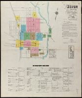
Sanborn fire insurance maps are a rich source of historic data on the urban built environment of North America during the 19th and early 20th centuries. The atlases were created for the purpose of underwriting fire insurance policies, which depended upon accurate and frequently-updated information about construction materials, municipal and transportation infrastructure, industrial and commercial landuse and more. The Yale University Library Map Department scanned its holdings of Sanborn fire insurance maps (consisting primarily of Connecticut towns) in order to make the maps more accessible.
Alternative Title:
Jan. 1931, New Milford, Conn.
Description:
"(1046). (11 sheets).", "Including Still River Station.", Contains information on population, prevailing winds, water facilities and fire department., Includes index of streets and specials., Partial cadastral map., and SMLMAPL 766 N472 1931: Sheets disbound. Library of Congress copyright stamp on title sheet.
Subject (Geographic):
New Milford (Conn.)--Maps
Subject (Name):
Library of Congress Stamp
Subject (Topic):
Fire risk assessment--Connecticut--New Milford--Maps and Real property--Connecticut--New Milford--Maps
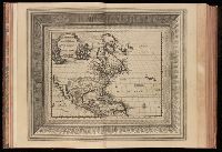
Collection of 19th Century maps in a variety of languages, belonging to Professor E.E. Salisbury., Preliminary record., and South America, North America, Western Hemisphere, Japan, West & Middle Africa, Istanbul, Strait of Bosporus and Country adjacent to the Black Sea.
"Table generale de l'ordre des feuilles et figures des LXVI tomes": t.1, p. [7]-37. Each section has also special table., 100 copies printed., t. 1. Portugal. -- t. [2-3] Espagne. -- t. 4-9. France. -- t. [10-12] Grande Bretagne & Irlande. --t. [13-16] Les Païs-Bas catholiques. -- t. [17-24] Les VII. Provinces Unies du Païs-Bas. -- t. [25-26] Suisse. -- t. [27-38] Italie. -- t. [39-42] L'empire d'Allemagne. -- t. [43] Danemarc, Norvegue & Suede. -- t. [44] Pologne, Prusse, Courlande, & Moscovie. -- t. [45-47] Hongrie, Turquie en Europe, Gréce, Archipel, Morée &c. -- t. [48-59] Asie. -- t. [60-62] Afrique. -- t. [63-66] Amerique. The prelminary descriptive leaves have continuous signatures., and Title-page in red and black; title vignette.
Publisher:
par Pierre vander Aa
Subject (Topic):
Atlases--Early works to 1800 and Geography--Pictorial works
Eastern Virginia showing the positions of the armies on March 15, 1862., Field of Bull Run showing the positions of the armies at 4:30 p.m. on August 29, 1862., and Field of Fredericksburg showing the positions of the troops on the morning of December 13, 1862.
Description:
Annotated in red and blue to show Union and Confederate positions., Eastern Virginia showing the positions of the armies on March 15, 1862 [Scale ca. 1:1,005,840] --, and Kentucky and Tennessee showing the positions of the armies on the morning of February, 6,
Publisher:
s.n,
Subject (Geographic):
United States--History--Civil War, 1861-1865--Maps
Subject (Name):
Ropes, John Codman, 1836-1899. Story of the Civil War
Carte routière pour automobilistes et cyclistes, Carte Taride, Cartes Taride pour automobilistes et cyclistes, and Nouvelle carte de France à l'usage des cyclistes et automobilistes
Description:
Also shows adjacent areas of Germany, Belgium, the Netherlands, Luxembourg, Switzerland, Italy, and Spain., Coverage complete in 34 sheets. Copy 2 incomplete., Each sheet separately numbered and titled: e.g., no. 3, Environs de Paris, section nord-est ; no. 27, Les bords du Rhin, Mayence à Strasbourg., Relief shown by shading and spot heights., and Some sheets dated in lower right corner, e.g., 5-18.
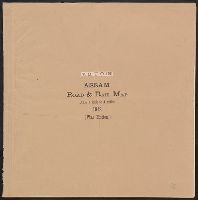
Assam road & rail map : and Map of Assam showing roads and railways
Description:
Includes 15 maps, title sheet, index to sheets (scale 1:2,027,520)., Ms. note attached on letterhead of Theodore Sizer detailing map provenance., and Shows boundaries, roads, railways, ferries, and villages.
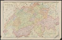
"Lithographie von B. Herder in Freiburg im Breisgau.", "Mitglied der königl. Academie der Kriegswissenschaften in Schweden der königl. geographischen Societaeten zu London und Paris der historischen Gesellschaft zu Freiburg i. B. & . &.", and [Title sheet] --
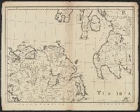
Subject (Geographic):
Switzerland--Maps
Subject (Name):
Herder, Bartholomä, 1774-1839, lithographer and K.K. Universitäts-Bibliothek Innsbruck Stamp
Contains also reproductions of L'Enfant's, Ellicott's and Dermott's maps. and Reproduced from original plats in the War department, by the Coast and geodetic survey, for use in a suit to establish the title of the government to the flats in the Potomac river,
Publisher:
N. Peters photo-lithographer
Subject (Geographic):
Washington (D.C.)--Maps--1791-1803
Subject (Name):
Dermott, James R.. Dermott or tin case map of the city of Washiington 1797-8, Ellicott, Andrew, 1754-1820. Plan of the city of Washington, and L'Enfant, Pierre Charles, 1754-1825. Plan of the city intended for the permanent seat of the g
[Maury map collection ; ser. A2], Maury's wind & current chart, S. Atlantic, Maury's wind & current chart, South Atlantic, Maury's wind and current chart, series A, South Atlantic, Maury's wind and current chart, South Atlantic, and South Atlantic
Description:
"Series A.", Copy imperfect: All sheets torn and repaired along, Does not cover the southeastern Atlantic south of latitude 40° S., Includes notes., Shows prevailing wind direction by month., and Various eds. of some sheets with updated and additional information.
Publisher:
United States Hydrographical Office,
Subject (Geographic):
South Atlantic Ocean--Charts, diagrams, etc
Subject (Name):
Flye, Wm, Maury, Matthew Fontaine, 1806-1873. Wind and current charts, Sherman & Smith, Temple, William G. (William Grenville), 1824-1894, United States Naval Observatory, United States. Bureau of Ordnance and Hydrography, and United States. Hydrographic Office
[Maury map collection ; Series D2], Maury's wind & current chart : South Atlantic, and South Atlantic
Description:
"Series D.", Copy imperfect: Sheets 1-4 torn and repaired along fold line, Does not cover the southeastern Atlantic south of latitude 40° S., and Originally intended to be complete in 6 sheets. Sheets 5 and 6, covering the southeastern Atlantic, were not issued.
Publisher:
United States Hydrographical Office,
Subject (Geographic):
South Atlantic Ocean--Maps
Subject (Name):
Maury, Matthew Fontaine, 1806-1873. Wind and current charts, Morris, Charles, 1784-1856, United States Naval Observatory, United States. Bureau of Ordnance and Hydrography, and United States. Hydrographic Office
Subject (Topic):
Nautical charts--South Atlantic Ocean and Ocean temperature--South Atlantic Ocean--Maps
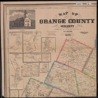
1 map on 4 sheets, each 72 x 71 cm. or smaller., Includes 30 insets of villages and towns, statistics, business directories and table of distances., and Includes 4 corner engravings: Vermont Capitol, Montpelier -- Thetford Academy -- Orange County Hotel, Chelsea Vt. -- Court House, Chelsea Vt.
Publisher:
Baker & Tilden,
Subject (Geographic):
Orange County (Vt.)--Maps
Subject (Name):
Baker & Tilden and H.F. Walling's Map Establishment
Subject (Topic):
Buildings--Vermont--Orange County--Pictorial works and Real property--Vermont--Orange County--Maps
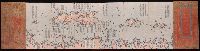
Peutinger table. and Tabula itineraria ex illustri Peutingerorum
Description:
Tabvlae Pevtingerianae segmentvm primvm, ab ostiis Rheni bonnam vsque -- Segmentvm secvndvm à bonna vsque ad Marcomannos -- Tabvlae Pevtingerianae segmentvm III a Marcomannis ad Sarmatas vsque -- Segmentvm IV a Sarmatis vsque ad Hamaxobios -- Tabvlae Pevtingerianae segmentvm V a Sarmatis Hamaxobis vsque ad Roxulanas -- Segmentvm VI a Sarmatis Roxulanis vsque ad Parnacos -- Tabvlae Pevtingerianae segmentvm VII a Parnacis vsque ad Paralocas Schythas -- Segmentvm VIII a Paralocis Schythis vsque ad finem Asiae.
Publisher:
prostant apud Joannem Janssonium,
Subject (Name):
Horn, Georg, 1620-1670, Jansson, Jan, 1588-1664. Accuratissima Orbis antiqui delineatio... [1652?], Jansson, Jan, 1588-1664. Novus atlas, Peutinger, Konrad, 1465-1546 or 7, and Welser, Marcus, 1558-1614
Subject (Topic):
Roads, Roman--Maps--Early works to 1800 and World maps--Early works to 1800
Anglo-American peace negotiations of 1782., Geological Survey bulletin ; 817., Hints of an acceptable minimum boundary., Map illustr, and Map illustrating compromise boundaries between Spanish dominions and the United States as proposed by French diplomacy, 1782.
Description:
Map illustrating Spanish territorial demands in 1782 -- Map illustrating compromise boundaries between Spanish dominions and the United States as proposed by French diplomacy, 1782 -- The Anglo-American peace negotiations of 1782 and Relief shown pictorially.
Publisher:
U.S. Geological Survey?,
Subject (Geographic):
North America--Maps--Early works to 1800--Facsimiles and United States--Boundaries--Maps--Early works to 1800--Facsimiles
Subject (Name):
Great Britain.--Treaties, etc.--United States,--1783 Sept. 3--Maps--Early works to 1800--Facsimiles, Jefferys and Faden, London, and Mitchell, John, 1711-1768. Map of the British and French dominions in North America
Subject (Topic):
British--America--Maps--Early works to 1800--Facsimiles and Maps--Early works to 1800--Facsimiles