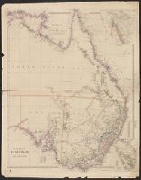
Map of eastern Australia (east of 130 ̊long.), considerably more detailed than his 1842 version, particularly in the region of Central Australia and inland in Victoria and New South Wales. Nort and Sheet measures 68 x 54 cm. Verso: "R Ser" in ink ms.
Publisher:
Pubd. ... by John Arrowsmith, 10 Soho Square,
Subject (Geographic):
Australia, Eastern--Administrative and political divisions--Maps and Australia, Eastern--Discovery and exploration--Maps
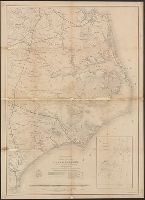
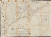
"May 1862.", Does not show military operations., Includes "Table of sounding and tides as given in the U.S.C.S. reports of 1855 & 1857.", and Indicates coastal fortifications, roads, railroads, drainage, canals, swamps, and towns.
Publisher:
The Bureau?,
Subject (Geographic):
North Carolina--History--Civil War, 1861-1865--Maps, North Carolina--Maps, and United States--History--Civil War, 1861-1865--Maps
"May 1862.", Does not show military operations., Includes "Table of sounding and tides as given in the U.S.C.S. reports of 1855 & 1857.", Indicates coastal fortifications, roads, railroads, drainage, canals, swamps, and towns., and Lower half of map only.
Publisher:
The Bureau?,
Subject (Geographic):
North Carolina--History--Civil War, 1861-1865--Maps, North Carolina--Maps, and United States--History--Civil War, 1861-1865--Maps
"The lands we are now controlling and offering for sale are colored in red.", Cadastral map., Includes text and "Table of land measures.", and Shows surveyed land sections by name or number, lands owned by railroad companies, and creeks.
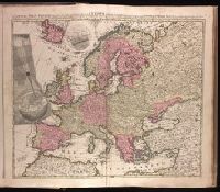
"Cum privilegio Amsteld. et Regis Poloniae .", Backed with paper. Ms. no. "3" in upper right-hand corner. Sheet measures 53.4 x 62.0 cm. No. 2 of 87 maps bound together., Includes two insets showing the path of the solar eclipse of May 12, 1706., Prime meridian: Ferro., and Relief shown pictorially.
Publisher:
Á Petro Schenk,
Subject (Geographic):
Europe--Maps--Early works to 1800.
Subject (Name):
Moolen, Simon van de. and Schenk, Peter, 1660-1718 or 1719.
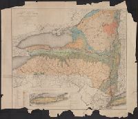
Imperfect: mutilated with some loss of text., Includes legends, note and references., Inset: [Long Island]., and Shows railroads and county boundaries.
Publisher:
University of the State of New York,
Subject (Geographic):
New York (State)--Maps
Subject (Name):
University of the State of New York
Subject (Topic):
Geology--New York (State)--Maps and Mines and mineral resources--New York (State)--Maps