"Constructed, projected and drawn by Fred D. Stuart, hydrographer, late of the U.S. Ex. Ex. ; assisted by John Tyssowski, draughtsman., "Entered according to act of Congress in the year 1851 by Cadwalader Ringgold ....", "Sheet no. 3.", and Inset views: View of Benicia from the anchorage east of Seal Island -- Mark for Tongue Shoal -- Entrance to the Sacramento River.
Publisher:
C.B. Graham, Lithr.,
Subject (Geographic):
Sacramento River (Calif.)--Maps, San Joaquin River (Calif.)--Maps, and Suisun Bay (Calif.)--Maps
Subject (Name):
Graham, C. B. (Curtis B.), Humphreys, William P. (William Penn), Knox, Samuel R, Rowe, J. H, Stuart, Fred D, and Tyssowski, John
Subject (Topic):
Nautical charts--California--Sacramento River, Nautical charts--California--San Joaquin River, and Nautical charts--California--Suisun Bay
"Constructed, projected and drawn by Fred D. Stuart, hydrographer, late of the U.S. Ex. Ex.", "Entered according to act of Congress in the 1851 by Cadwalader Ringgold ....", "Sheet no. 1.", Inset view: Entrance to San Francisco., and Place names in English and Spanish.
Publisher:
C.B. Graham, Lithr.,
Subject (Geographic):
San Francisco Bay (Calif.)--Maps and San Francisco Bay Area (Calif.)--Maps
Subject (Name):
Blunt, Simon Fraser, d. 1854, Graham, C. B. (Curtis B.), and Stuart, Fred D
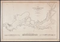
"Entered according to act of Congress in the year 1851 by Cadwalader Ringgold ....", "Projected, constructed & drawn by Fred D. Stuart, hydrographer, late of the U.S. Ex. Ex. ; assisted by A.H. Campbell, civil engineer.", "Sheet no. 4.", and Depths shown by soundings.
Publisher:
C.B. Graham, Lithr.,
Subject (Geographic):
Sacramento River (Calif.)--Maps
Subject (Name):
Campbell, Albert H. (Albert Henry), 1826-1899, Cullberg, Edwin, Emmet, T. A, Graham, C. B. (Curtis B.), and Stuart, Fred D
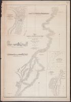
"Entered according to act of Congress in the year 1851 by Cadwalader Ringgold ....", "Projected, constructed & drawn by Fred D. Stuart, hydrographer, late of the U.S. Ex. Ex. ; assisted by A.H. Campbell, civil engineer.", "Sheet no. 2.", and Inset views: Mark for invincible buoy, north extreme of Marin Is. on with clump of trees north of San Rafael -- Mark for invincible buoy, Point Smith, east end of Angel I. on with Signal Hill.
Publisher:
C.B. Graham, Lithr.,
Subject (Geographic):
San Francisco Bay (Calif.)--Maps, San Francisco Bay Area (Calif.)--Maps, and San Pablo Bay (Calif.)--Maps
Subject (Name):
Blunt, Simon F, Campbell, Albert H. (Albert Henry), 1826-1899, Graham, C. B. (Curtis B.), and Stuart, Fred D
Subject (Topic):
Nautical charts--California--San Francisco Bay and Nautical charts--California--San Pablo Bay
National Geographic Society (U.S.). Cartographic Section
Published / Created:
1945
Call Number:
56 1945
Container / Volume:
BRBL_00296
Image Count:
1
Resource Type:
Maps, Atlases & Globes
Description:
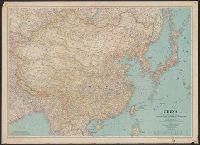
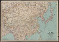
"June 1945.", Accompanied by: Index to Map of China / prepared in the Cartographic Department of the National Geographic Society for the National Geographic Society Magazine with 7,986 place names (35 p. ; 20 cm.)., and Relief shown by shading and spot heights.
Publisher:
Lithographed by A. Hoen and Co., and National Geographic Society ;
National Geographic Society (U.S.). Cartographic Section
Published / Created:
1945
Call Number:
56 1945
Container / Volume:
BRBL_00296
Image Count:
1
Resource Type:
Maps, Atlases & Globes
Description:
"June 1945.", Accompanied by: Index to Map of China / prepared in the Cartographic Department of the National Geographic Society for the National Geographic Society Magazine with 7,986 place names (35 p. ; 20 cm.)., and Relief shown by shading and spot heights.
Publisher:
Lithographed by A. Hoen and Co., and National Geographic Society ;