" ... a modern interpretation of the 5,000 year-old quipu, which recorded the literature of the Incas on knotted cords. It ... embodies the intention and essence of a poem by Vicuña translated into English by the poet along with Jerome Rothenberg. Accompanying Chanccani Quipu is a full-color signed drawing inserted into a pamphlet entitled Instruction Manual & Orientation to Various Meanings"--Publisher description., " ... produced and published by Granary Books in an edition of 32 copies each made entirely by hand. The poem was "printed" on unspun wool using stencils made by the poet who also knotted the threads. The quipu is tied or bound to a 16 inch bamboo spine from which it hangs to about 48 inches when installed. The work is housed in a hand-stenciled box (18 1/2 x 18 1/4 x 4 inches) made by Susan Mills. Silicon Gallery Fine Art Prints in Philadelphia printed the drawing and the pamphlet in full-color. Cecilia Vicuña and Jerome Rothenberg signed the edition of 32 numbered copies"--Publisher description., and 10/32. Autographs of Cecilia Vicuña and Jerome Rothenberg. In box as issued.
Publisher:
Granary Books,
Subject (Name):
Granary Books (Firm), publisher., Mills, Susan (Susan E.), Rothenberg, Jerome, 1931-, Rothenberg, Jerome,--1931---Autograph., Silicon Gallery Fine Art Prints, printer., and Vicuña, Cecilia--Autograph.
"Constructed, projected and drawn by Fred D. Stuart, hydrographer, late of the U.S. Ex. Ex.", "Entered according to act of Congress in the 1851 by Cadwalader Ringgold ....", "Sheet no. 1.", Inset view: Entrance to San Francisco., and Place names in English and Spanish.
Publisher:
C.B. Graham, Lithr.,
Subject (Geographic):
San Francisco Bay (Calif.)--Maps and San Francisco Bay Area (Calif.)--Maps
Subject (Name):
Blunt, Simon Fraser, d. 1854, Graham, C. B. (Curtis B.), and Stuart, Fred D
"Entered according to act of Congress in the year 1851 by Cadwalader Ringgold ....", "Projected, constructed & drawn by Fred D. Stuart, hydrographer, late of the U.S. Ex. Ex. ; assisted by A.H. Campbell, civil engineer.", "Sheet no. 2.", and Inset views: Mark for invincible buoy, north extreme of Marin Is. on with clump of trees north of San Rafael -- Mark for invincible buoy, Point Smith, east end of Angel I. on with Signal Hill.
Publisher:
C.B. Graham, Lithr.,
Subject (Geographic):
San Francisco Bay (Calif.)--Maps, San Francisco Bay Area (Calif.)--Maps, and San Pablo Bay (Calif.)--Maps
Subject (Name):
Blunt, Simon F, Campbell, Albert H. (Albert Henry), 1826-1899, Graham, C. B. (Curtis B.), and Stuart, Fred D
Subject (Topic):
Nautical charts--California--San Francisco Bay and Nautical charts--California--San Pablo Bay
Mexico. Dirección de Estudios Geográficos y Climatológicos
Published / Created:
[1922]
Call Number:
8891 1922
Container / Volume:
BRBL_00656
Image Count:
2
Resource Type:
Maps, Atlases & Globes
Description:
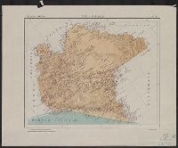
"No. 5.", Accompanied by physiographic plate covering same area, showingonly relief and drainage (1 sheet : col. ; 46 cm.)., Appears in Atlas geográfico de la República Mexicana., Oriented with north toward upper left., and Relief shown by shading.
Publisher:
La Dirección,
Subject (Geographic):
Chiapas (Mexico)--Maps
Subject (Name):
Mexico. Dirección de Estudios Geográficos y Climatológicos. Atlas geográfico de la República Mexicana
Mexico. Dirección de Estudios Geográficos y Climatológicos
Published / Created:
[1922]
Call Number:
8819 1922
Container / Volume:
BRBL_00652
Image Count:
2
Resource Type:
Maps, Atlases & Globes
Description:
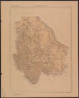
Accompanied by physiographic plate, showing relief and drainage only (1 sheet : col. ; 70 cm.)., In upper right margin: No. 6., and Relief shown by shading.
Mexico. Secretaría de Estado y del Despacho de Relaciones Interiores y Exteriores
Published / Created:
1822
Call Number:
1991 +S5 1822 10/14 1
Image Count:
3
Resource Type:
Books, Journals & Pamphlets
Description:
Circular justifying the government's actions in supressing an alleged Republican conspiracy in August 1822. and Dated and signed at end (p. [2]): México 14 de octubre de 1822. Herrera.
Subject (Geographic):
Mexico--Politics and government--1821-1861
Subject (Name):
Herrera, José Manuel de, 1776?-1831 and Wagner, Henry Raup, 1862-1957--Collection
Subject (Topic):
Conspiracies--Mexico, Lat Amer Tracts--1822, and Republicanism--Mexico