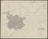
Great Britain. War Office. General Staff. Geographical Section
Published / Created:
1943
Call Number:
408 V83 1943
Container / Volume:
BRBL_00239
Image Count:
1
Resource Type:
Maps, Atlases & Globes
Alternative Title:
Geographical Section, General Staff ; no. 4379, GSGS (Series) ; 4379., and Sicily 1:5,000
Description:
"6-43.", "Air photographs have been used in the production of this plan.", "Authorities: Italy 1:25,000 G.S.G.S. no.4228 sheet 276 IV N.W.1941, Italy 1:100,000 G.S.G.S. no.4164 sheet 276 1942, intelligence informa, and Relief shown by contours and rock drawings.
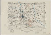
Great Britain. War Office. General Staff. Geographical Section
Published / Created:
1943
Call Number:
685gm 1943
Container / Volume:
BRBL_00351
Image Count:
2
Resource Type:
Maps, Atlases & Globes
Alternative Title:
Geographical Section, General Staff ; no. 4408 and GSGS (Series) ; 4408.
Description:
"Copied from an Italian map date 1940, compiled by Sezione topografica del fronti Tunisini.", "Published by War Office, 1943.", Insets: Ghardimaou.--Nefza.--Souk-el-Arbd.--Souk, and Twelve classes of roads and tracks, and three gauges of railroads are indicated.
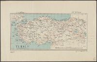
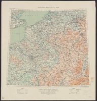
Great Britain. War Office. General Staff. Geographical Section
Published / Created:
1915
Call Number:
11hc 1915E
Image Count:
1
Resource Type:
Maps, Atlases & Globes
Alternative Title:
Geographical Section General Staff ; 3024 and GSGS (Series) ; 3024.
Description:
Ms. notes outside bottom right margin: "Based on Paris M31, Frankfurt M32, Lyons L31 & Milan L32, of Europe 1:1,000,000.", Relief shown as contours and gradient tints., and Shows: international boundaries, relative importance of towns, railways (2 categories),
Publisher:
G.S.G.S.,
Subject (Geographic):
Belgium--Maps and France--Maps
Subject (Topic):
World War, 1914-1918--Belgium--Maps and World War, 1914-1918--France--Maps