Colton, J. H. (Joseph Hutchins), 1800-1893, creator.
Published / Created:
[1855]
Call Number:
BrSides 2019 90
Image Count:
2
Resource Type:
Maps, Atlases & Globes
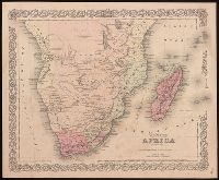
Description:
"Entered according to Act of Congress in the year 1855 by J.H. Colton & Co. in the Clerks Office of the District Court of the United States for the Southern District of New York.", "No. 36" in power right corner., From Colton's Atlas of the world., Prime meridian: Washington, D.C., Relief shown by hachures., and Text on verso with caption title "Cape of Good Hope--Cape Colony."
Publisher:
Published by J.H. Colton,
Subject (Geographic):
Africa, Southern--Maps.
Subject (Name):
Colton, G. Woolworth (George Woolworth), 1827-1901. Colton's atlas of the world.
"Entered according to acts of Congress in the year 1863 by J. H. Colton in the Clerks Office of the District Court of the United States for the Southern District of New York.", Insets: Southern part of Florida ; Proposed railroad routes to the Pacific Ocean., Prime meridian: Washington, D.C., Prime meridian: Washington., Printed by Lang & Cooper., and Relief shown by hachures.
Publisher:
J.H. Colton, 172 William Street,
Subject (Geographic):
Confederate States of America--History--Civil War, 1861-1865--Maps. and Southern States--Maps.
Subject (Name):
Colton, J. H. (Joseph Hutchins), 1800-1893., Lang & Cooper, printer., and Rusling, James Fowler, 1834-1918.
Map of Cook's tours in Ireland. and Map of Cook's tours in Scotland & England.
Description:
Coordinates not present on map and are approximated., Imperfect: brittle and chipped, with some loss of text., Inset: Portion of Norway and Sweden., On verso: Map of Cook's tours in Ireland; Map of Cook's tours in Scotland & England., and Shows railroads, "Railways over which Cook's tickets are available," and steamship routes.
Atwood, John M., approximately 1818- cartographer.
Published / Created:
1849
Call Number:
71 1849
Image Count:
1
Resource Type:
Maps, Atlases & Globes
Description:
Includes 2 insets, ill., and distance table., Prime meridians: Greenwich and Washington., Relief shown by hachures and spot heights., Shows California's gold region and western trails., and Variant ed. in same year.
Publisher:
J.H. Colton,
Subject (Geographic):
California--Gold discoveries--Maps., North America--Maps., and United States--Maps.
Subject (Name):
Colton, J. H. (Joseph Hutchins), 1800-1893, publisher.
"Entered according to act of Congress, in the year 1853, by J.H. Colton, in the Clerks Office of the District Court of the United States for the Southern District of New York.", Prime meridians: Greenwich and Washington., Relief shown by hachures., and Shows state boundaries, major cities and towns, railroads, canals, military outposts, Indian tribal areas, "Indian Territory," the western territories of the United States, and Virginia as one state.
Publisher:
Published by J.H. Colton & Co., No. 172 William St.,
Subject (Geographic):
Indian Territory--Maps, Oklahoma --Maps, and United States--Maps