
You Searched For
1 - 9 of 9
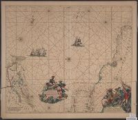
Search Results
2.
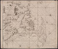
- Creator:
- Keulen, Johannes van, 1654-1715
- Published / Created:
- [1695]
- Call Number:
- 73 1680
- Container / Volume:
- BRBL_00688
- Image Count:
- 1
- Resource Type:
- Maps, Atlases & Globes
- Description:
- "22" in lower left and lower right corners., Appears in Keulen's De groote nieuwe vermeerderde zee-atlas ofte water-waereld., Ms., Shoal added around Accadie., and Shows Gulf of St. Lawrence from Newfoundland to the Gaspé, soundings indicated on the Grand Banks.
- Publisher:
- By Johannes van Keulen ...,
- Subject (Geographic):
- Atlantic Provinces--Maps--Early works to 1800 and Saint Lawrence, Gulf of--Maps--Early works to 1800
- Subject (Name):
- Keulen, Johannes van, 1654-1715. Groote nieuwe vermeerderde zee-atlas ofte water-waereld
- Found in:
- Beinecke Rare Book and Manuscript Library > Pas-Kaart, vande zee-kusten van Terra Nova met de Byleggende zee- kusten van Francia Nova Canada en Accadie van C. de Sables tot de Mond van de Straad Davids toe Door C.J. Vooght Geometra [cartographic material].

- Creator:
- Jacobsz, Theunis, 1632?-1679
- Published / Created:
- [1666?]
- Call Number:
- BrSides Folio 2019 84
- Image Count:
- 1
- Resource Type:
- Maps, Atlases & Globes
- Description:
- "1" in lower right corner., Coordinates not present on map and are approximated., and Manuscript number on left margin: 15.
- Publisher:
- by Theunis Iacobss op't Water inde Lootsman,
- Subject (Geographic):
- Mediterranean Sea--Maps--Early works to 1800.
- Subject (Topic):
- Nautical charts--Mediterranean Sea--Early works to 1800.
- Found in:
- Beinecke Rare Book and Manuscript Library > Pascaarte van t'westlyckste deel vande Middelandsche Zee : waer in vertoont wort de ware gelegenheden van alle rivieren, havens, capen, droogten ende bayen alles synde op hare streckingen en distantien geleyt.

- Creator:
- Goos, Pieter, approximately 1616-1675
- Published / Created:
- anno 1666.
- Call Number:
- 23cea 1666
- Container / Volume:
- BRBL_00682
- Image Count:
- 1
- Resource Type:
- Maps, Atlases & Globes
- Alternative Title:
- Pascaerte vande Zvyd-Zee tussche California, en Ilhas de Ladrones
- Description:
- Chart of the Pacific Ocean showing the coastlines of Tasmania, Carpentaria, New Guinea, Japan, California, and Pacific Islands., Mounted on linen. Cross Collection no., and Scale is given in English, French, Dutch, and Spanish miles.
- Publisher:
- By Pieter Goos, op't Waater inde Vergulde Zeespiegel,
- Subject (Geographic):
- Pacific Ocean--Maps--Early works to 1800
- Subject (Name):
- Goos, Pieter, approximately 1616-1675. Zee-atlas ofte water-wereld
- Found in:
- Beinecke Rare Book and Manuscript Library > Pascaerte vande Zuyd-Zee tussche California, en Ilhas de Ladrones [cartographic material] / by Pieter Goos, op't Waater inde Vergulde Zeespiegel.
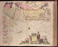
- Creator:
- Keulen, Johannes van, 1654-1715.
- Published / Created:
- [ca. 1734]
- Call Number:
- 1973 Folio 18
- Image Count:
- 1
- Resource Type:
- Maps, Atlases & Globes
- Alternative Title:
- Paskaartie van de rievier de Elve streckende van Oldenbroek tot Hamburgh.
- Description:
- "Met priviligie voor 15 Laar"., Appeared in Gerard van Keulen's Nieuwe groote ligtende Zee-Fakkel ... 1734; cf. Koeman, C. Atlantes Neerlandici, IV, Keu 45, map 10., Bar scales given in "Duytsche Mylen," "Spaensche Mylen," and "Eng. en Fransiche Mylen"., Depths shown by soundings., Imperfect: western sheet wanting. Backed with paper. Ms. no. "44" in upper right-hand corner. No. 42 of 87 maps bound together., Inset: Paskaartie van de rievier de Elve streckende van Oldenbroek tot Hamburgh., With arrow indicating sea current., and With north oriented towards the bottom.
- Publisher:
- By Ioannes van Keulen, Boekverkooper en Graetboogmaaker aan de Nieubrug in de Gekroonde Loots-man,
- Subject (Geographic):
- Groningen (Netherlands : Province)--Maps--Early works to 1800., Lower Saxony (Germany)--Maps--Early works to 1800., and North Sea--Maps--Early works to 1800.
- Subject (Name):
- Keulen, Gerard van. Nieuwe groote lichtende zee-fakkel.
- Subject (Topic):
- Nautical charts--North Sea--Early works to 1800.
- Found in:
- Beinecke Rare Book and Manuscript Library > Paskaarte vande kuste van Holland en Vriesland, Groeninger, Emder en Keydingerland, Holstyn, Ditmarsche en 't Eydersted [cartographic material] : met de Riviere Eylande Droogte en Diepten die geleege zijn tussen Olant en Egmont op Zee / gelegt en verbeeterd naar Mathurin Guitet ....
6.
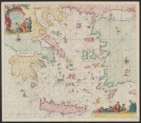
- Creator:
- Keulen, Johannes van, 1654-1715
- Published / Created:
- [1680?]
- Call Number:
- 489 1680
- Container / Volume:
- BRBL_00266
- Image Count:
- 1
- Resource Type:
- Maps, Atlases & Globes
- Alternative Title:
- Archipel en de eylanden daer omtrent gelegen
- Description:
- "Met priviligie voor 15 Iaar.", Appears in the author's De groote niewe vermeerderde zee-atlas ofte water-waereld., Dutch, with Latin place names., Has watermark., and Includes col. ill., decorative cartouche, and rhumb lines.
- Publisher:
- By Ioannes van Keulen, boeck verkooper en graad boogh maker, aen de N:Brugh inde gekroonde Loots,
- Subject (Geographic):
- Aegean Islands (Greece and Turkey)--Maps--Early works to 1800 and Crete (Greece)--Maps--Early works to 1800
- Subject (Name):
- Keulen, Johannes van, 1654-1715. Groote nieuwe vermeerderde zee-atlas ofte water-waereld
- Subject (Topic):
- Coasts--Aegean Sea--Maps--Early works to 1800
- Found in:
- Beinecke Rare Book and Manuscript Library > Paskaerte vande archipel en de eylanden daer omtrent gelegen, als Candia, Serigo en Rodus, tusschen Golfo de Lepanto, Constantinopolen en C. Serdeni in Natolia.
- Creator:
- Wit, Frederik de
- Published / Created:
- [1675]
- Call Number:
- 21cea 1680
- Container / Volume:
- BRBL_00682
- Image Count:
- 1
- Resource Type:
- Maps, Atlases & Globes
- Alternative Title:
- Terra Neuf, en de custen van Nieu Engeland, Nieu Nederland, Nieu Andalusia, Guiana en Venezuela
- Description:
- Covers the Atlantic Ocean west of the Azores and Cape Verde Islands, and the coasts of northeastern North America and northern South Amerca., Fr, In Latin and Dutch., Includes two decorative cartouches and ill., North oriented to left., and With "22" at top right.
- Publisher:
- Gedruckt by Fredrick de Wit in de Kalverstrae,
- Subject (Geographic):
- Atlantic Provinces--Maps--Early works to 1800 and North Atlantic Ocean--Maps--Early works to 1800
- Subject (Name):
- Wit, Frederik de. Orbis Maritimus ofte Zee Atlas
- Subject (Topic):
- Nautical charts--Atlantic Ocean--Early works to 1800
- Found in:
- Beinecke Rare Book and Manuscript Library > Terra Nova ac maris tractus circa Novam Franciam, Angliam, Belgium, Venezuelam, Novam Andalusiam, Guianam, et Brasiliam / Apu[d] F. de Wit = Terra Neuf en de custen van Nieu Engeland, Nieu Nederland, Nieu Andalusia, Guiana en Venezuela / Fredrick de Wit.
8.

- Creator:
- Wit, Frederik de
- Published / Created:
- [1715]
- Call Number:
- 70 1715
- Container / Volume:
- BRBL_00686
- Image Count:
- 1
- Resource Type:
- Maps, Atlases & Globes
- Alternative Title:
- Terra neuf, en de custen van Nieu Vranckryck, Nieu Engeland, Nieu Nederland, Nieu Andalusia, Guiana en Venezuela
- Description:
- At upper right corner: Fol. 26., Covers the Atlantic Ocean west of, From Renard's Atlas de la navigation et du commerce ... Amsterdam : Chez Louis Renard, 1715., In Latin and Dutch., Includes two decorative cartouches and ill., and Oriented with north to the left.
- Publisher:
- Gedruckt by L. Renard,
- Subject (Geographic):
- North Atlantic Ocean--Maps--Early works to 1800
- Subject (Name):
- Renard, Louis. Atlas de la navigation et du commerce
- Subject (Topic):
- Nautical charts--North Atlantic Ocean--Early works to 1800
- Found in:
- Beinecke Rare Book and Manuscript Library > Terra nova, ac maris tractus circa Novam Franciam, Angliam, Belgium, Venezuelam Novam, Andalusiam, Guianan, et Brasiliam / L. Renard = Terra neuf, en de custen van Nieu Vranckryck, Nieu Engeland, Nieu Nederland, Nieu Andalusia, Guiana en Venezuela.
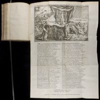
- Creator:
- Tysens, Gysbert, 1693-1732
- Published / Created:
- [ca. 1731]
- Call Number:
- 2011 1541
- Image Count:
- 1
- Description:
- Illustrated broadside poem. and No. 3 of 4 titles bound together (bound after title page of 2nd title).
- Publisher:
- By Gerrit Bos, en Gerrit Bouman, boekverkoopers,
- Subject (Topic):
- Executions and executioners--Pictorial works, Homosexuality--Law and legislation--Pictorial works, Homosexuality--Poetry, and LGBTQ resource
- Found in:
- Beinecke Rare Book and Manuscript Library > Tydelyke straffe voorgesteld ten afschrik aller goddeloze en doemwaardige zondaren / G. Tysens.