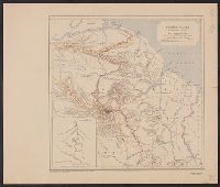
Route and surveys of the South Magnetic Polar Party, 1908-09 : and The Geographical journal.
Description:
At top right corner of sheet: Antarctic regions. Shackleton. and Map showing the route taken by the South Magnetic Pole Party in Shackleton's British Antarctic Expedition. The route is time-dated over late 1908 to early 1909. The map also includes the routes
Publisher:
Royal Geographical Society,
Subject (Geographic):
Antarctica--Discovery and exploration--Maps, South Magnetic Pole (Antarctica)--Discovery and exploration--Maps, and South Victoria Land--Discovery and exploration--Maps
Subject (Name):
British Antarctic Expedition (1907-1909)--Maps and Royal Geographical Society (Great Britain). Australian Antarctic Division
Subject (Topic):
Scientific expeditions--Antartica--South Victoria Land--Maps
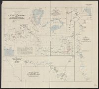
Route and surveys of the Southern Journey Party, 1908-09 : and The Geographical journal.
Description:
Map showing the area explored by Ernest Shackleton's Southern Journey Party over the period 1908-1909 during the British Antarctic Expedition, 1907-1909. The route toward the South Pole is time-dated for the inward journey from Nov. 25, 1908-Jan. 9, 1909, and the southern-most point that the party reached is marked at 162E̊/88S̊23'. Land relief is indicated by spot heights, hachures and contours.
Publisher:
Royal Geographical Society,
Subject (Geographic):
Antarctica--Discovery and exploration--Maps and South Pole--Discovery and exploration--Maps
Subject (Name):
British Antarctic Expedition (1907-1909)--Maps, Royal Geographical Society (Great Britain). Australian Antarctic Division, and Shackleton, Ernest Henry Sir, 1874-1922
Includes 3 insets: Tour to Trossachs--Loch Katrine & Loch Lomond-- and ill. of station hotels at Glasgow, Perth and Edinburgh. and Travel information on verso.
Publisher:
John Bartholomew,
Subject (Geographic):
Scotland--Maps
Subject (Name):
Caledonian Railway Company and Edinburgh Geographical Institute
Central Africa, Alexander and Route of the Alexander-Gosling expedition from the River Niger to the Red Sea, 1904-7
Description:
Ancillary maps: [1.] Map of part of Lake Chad -- [2.] Map of part of the River Bamingi -- [3.] Map of the Kibali River -- [4.] Map of the River Yei. and In upper right margin: The Geographical Journal, 1907.
Survey of the Uganda-Congo boundary on the western frontier of the Uganda Protectorate
Description:
"The geographical journal, 1909.", "The Ugand, Includes tables, profile, inset location map, and inset map: Diagram of main triangulation on the Uganda-Congo boundary., Relief shown by shading, contours, and spot heights., and Sheet measures 55 x 52 cm.
Publisher:
Royal Geographical Society,
Subject (Geographic):
Congo (Democratic Republic)--Boundaries--Uganda--Maps and Uganda--Boundaries--Congo (Democratic Republic)--Maps