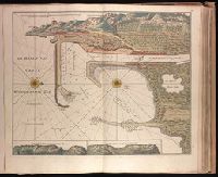
"Aende nieuwe-brug met previlegie"., Backed with paper. Ms. no. "10" in upper right-hand corner. Sheet measures 53.5 x 62.5 cm. No. 9 of 87 maps bound together., Bar scale given in "Duytsche Myl"., Relief shown pictorially; depths shown by soundings., Watermark., and With north oriented towards upper left.
Publisher:
By Gerard van Keulen,
Subject (Geographic):
Wismar (Germany)--Maps--Early works to 1800.
Subject (Topic):
Nautical charts--Germany--Wismar Bay--Early works to 1800.
"Aen de nieuwen brugh met previlegi"., Backed with paper. Ms. no. "58" in upper right-hand corner. Sheet measures 53.7 x 62.3 cm. No. 53 of 87 maps bound together., Bar scale given in "Duytsche Myl"., Relief shown pictorially; depths shown by soundings., With north oriented towards the right., and With two inset maps at bottom: "Caap Cette N W ten N4" and "Caap Cette N W ten W 3."
Publisher:
By Gerard van Keulen,
Subject (Geographic):
Sète (France)--Maps--Early works to 1800.
Subject (Topic):
Nautical charts--France--Sète--Early works to 1800.
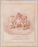
"The Convention, a creature with the body of a stout woman and with seven monstrous and demoniac heads, sits full-face in an accoucheur's chair. A little demon on the ground holds up a pitchfork. A French surgeon, smiling (right), with shirt-sleeves rolled up, holds a clumsy pair of forceps; a Dutch accoucheur, fat and senile, peers into a folio volume: 'Sectio Caes: et Sectio Synchondroseos'. '. . . L'accoucheur Français, homme experimenté, prévoit ses terribles convulsions, et s'est déja muni du forceps. Son collegue Hollandais, dont les craintes vont encore plus loin, repete la théorie de l'incision Caesarienne. Il faudrait effectivement un Caesar, pour couper court à tout proces.' Text, 'Isaiah', xiv. 29. Her fruit shall be a fiery flying serpent."--British Museum online catalogue.
Description:
Artist identified as Hess and printmaker questionably identified as Gillray in the British Museum catalogue., One of twenty plates published as a bound set entitled: Hollandia regenerata., Place and date of publication from British Museum catalogue., Plate numbered "19" in upper left corner., Possibly published by Hannah Humphrey. See British Museum catalogue., Temporary local subject terms: Holland: civil discord -- Conventions -- Surgeons -- Medical instruments: forceps -- Physicians: Dutch accoucheurs -- Monsters., Title etched below image., and With: Letterpress explanation in French that includes appropriate texts from the Bible in Dutch and in English.
Subject (Name):
Auchincloss, Hugh Dudley--Ownership., Harvey, Francis--Ownership., and Hess, David, 1770-1843, artist.
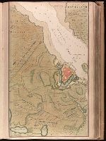
Backed with paper. Ms. no. "13" in upper right-hand corner. Sheet measures 53.6 x 35.5 cm. No. 13 of 87 maps bound together., Bar scale given in "Duytsche Mylen"., Relief shown pictorially; depths shown by soundings., Shows troop positions during siege of Stralsund during the Northern War, ca. 1715., and Title derived from place locations on map.
Publisher:
By Gerard van Keulen ...,
Subject (Geographic):
Rügen Island (Germany)--Maps--Early works to 1800. and Stralsund (Germany)--Maps--Early works to 1800.
Subject (Name):
Anse, Luggert van, fl. 1690-1716, engraver.
Subject (Topic):
Nautical charts--Baltic Sea--Early works to 1800. and Northern War, 1700-1721--Maps.
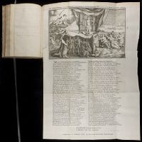
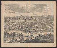
From Augustin Calmet's Byvoegzel tot het algemeen groot historisch, oordeelkundig, chronologisch, geografisch, en letterlyk naam- en woord-boek (1731). and Watermark.
Publisher:
[Samuel Luchtmans],
Subject (Geographic):
Antioch (Turkey)--Pictorial works--Early works to 1800.
Subject (Name):
Calmet, Augustin, 1672-1757. Byvoegzel tot het algemeen groot historisch, oordeelkundig, chronologisch, geografisch, en letterlyk naam- en woord-boek. and Luchtmans, Samuel, 1685-1757
Bird's-eye view., Dutch and English., From Ogilby's Africa, being an accurate description of the regions of Egypt, Barbary, Lybia and Billedulgerid. 1670., Has watermarks., Includes ill. and indexes of points of interest., and Relief shown pictorially.
Publisher:
Printed by T. Johnson for the author,
Subject (Geographic):
Loango (Congo)--Aerial views--Early works to 1800
Subject (Name):
Ogilby, John, 1600-1676. Africa, being an accurate description of the regions of Egypt, Barbary, Lybia and Billedulgerid
Affbeeldinghe der custen des landts genaempt terra do Natal, item van alle de custen van Coffala, Mozambique, Melinde and Typus orarum maritimarum Guineae, Manicongo, & Angôlae ultra promontorium Bonae Spei.
Description:
Appears in the author's Itinerario, voyage ofte schipvaert van Jan Huygen van Linschoten naer Oost ofte Portugaels Indien., Companion map to Typus orarum maritimarum Guineae, Manicongo, & Angôlae ultra promontorium Bonae Spei ..., and Includes decorative carto
Publisher:
Cornelis Claesz?,
Subject (Geographic):
Africa, Eastern--Maps--Early works to 1800
Subject (Name):
Claesz, Cornelis, approximately 1546-1609, Langren, Arnold Florent van, 1580-1644, and Linschoten, Jan Huygen van, 1563-1611. Itinerario, voyage ofte schipvaert van Jan Huygen van Linschoten naer Oost ofte Portugaels Indien
Subject (Topic):
Coasts--Africa, Eastern--Maps--Early works to 1800