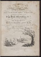
Chart comprizi, Chart containing part of the Icy Sea with the adjacent coast of Asia and America., North America and the West Indies, with the opposite coasts of Europe and Africa., and South America with the adjacent islands in the Southern Ocean and South Sea.
Description:
"Publish'd according to act of Parliament, 10 June 1775, by Robt. Sayers & J. Bennett, No. 53 in Fleet Street." and Chart containing part of the Icy Sea with the adjacent coast of Asia and America -- Chart comprizing Greenland with the countries and islands a
Publisher:
Robt. Sayer & J. Bennett,
Subject (Geographic):
America--Discovery and exploration--Maps--Early works to 1800 and America--Maps--Early works to 1800
Subject (Name):
Green, John, d. 1757, Jefferys, Thomas, d. 1771, and Robert Sayer and John Bennett (Firm)
Chart comprizing Greenland with the countries and islands about Baffins Bay and part of Hudsons Bay., Chart containing part of the Icy Sea with the adjacent coast of Asia and America., and Chart containing the coasts of California, New Albion, and Russian disco
Description:
"Publish'd according to act of Parliament, 10 June 1775, by Robt. Sayers & J. Bennett, No. 53 in Fleet Street.", Chart containing part of the Icy Sea with the adjacent coast of Asia and America -- Chart comprizing Greenland with the countries and islands about Baffins Bay and part of Hudsons Bay -- Chart containing the coasts of California, New Albion, and Russian discoveries to the north ... -- North America and the West Indies, with the opposite coasts of Europe and Africa -- Chart containing the greater part of the South Sea to the south of the line, with the islands dispersed thro' the same -- South America with the adjacent islands in the Southern Ocean and South Sea., Includes text, historical and geographical notes, ill. of ships, and tables of comparative astronomical observations., Individual sheets marked I-VI below neat line at right., Possibly from Thomas Jefferys' American atlas., Prime meridian: London and Ferro., Relief shown pictorially., Sheets pasted together to make 3 maps. Sheets measure 55 x 116.5 cm. or smaller. Cross Collection nos. 67 and 136., Shows nautical exploration routes., and Title from sheets 1 and 2.
Publisher:
Robt. Sayer & J. Bennett,
Subject (Geographic):
America--Discovery and exploration--Maps--Early works to 1800 and America--Maps--Early works to 1800
Subject (Name):
Green, John, d. 1757, Jefferys, Thomas, d. 1771, and Robert Sayer and John Bennett (Firm)
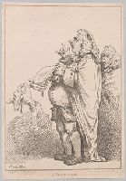
"An obese and carbuncled barrister stands in profile to the left, shouting with raised fingers; in his left hand is a sheaf of papers. He wears the wig of a serjeant-at-law, with its black patch (cf. No. 5900), and his gown drapes his old-fashioned professional dress. Behind him (right) stands a senile-looking and spectacled colleague, while a third (left), also in a serjeant's wig, sits in back view in an arm-chair."--British Museum online catalogue.
Alternative Title:
Councillor
Description:
A companion print to: A money scrivener., Printseller's announcement following publication statement: Folios of caracatures [sic] lent out for the evening., and Title etched below image.
Publisher:
Pub. Jany. 1st, 1801, by S.W. Fores, No. 50 Piccadilly,
Subject (Name):
Auchincloss, Hugh Dudley--Ownership., Fores, S. W., publisher., and Harvey, Francis--Ownership.
At upper right, the seal of the Great Mogul, with English transliteration., From Samuel Purchas's Purchas his pilgrimes (1625)., and In upper right corner: 579.
Publisher:
[Printed by W. Stansby for H. Fetherstone],
Subject (Geographic):
South Asia--Maps--Early works to 1800.
Subject (Name):
Featherstone, Henry, -1647, Purchas, Samuel, 1577?-1626. Purchas his Pilgrimage., and Stansby, William, active 1597-1638
Hand colored., Relief shown pictorially., Shows "West longitude from London" and "from Philadelphia.", and Single sheet, uncolored, mounted on linen. Dimensions: 48 x 65 cm. Recto: Stamped "Yale Horace Brown 1900S".
Publisher:
Sold by T. Jefferys,
Subject (Geographic):
North America--Maps--Early works to 1800 and Northeastern States--Maps--Early works to 1800
Subject (Name):
Evans, Lewis, 1700?-1756, Jefferys, Thomas, d. 1771, and Mellon, Paul--Bookplate
Includes historical notes, text, 3 distance charts, and inset of "A sketch of the remaining part of Ohio R. &c.", Prime meridians: Philadelphia and London., and Relief shown pictorially.
Publisher:
Sold by R. Sayer in Fleet Street & T. Jefferys, Charing Cross,
Subject (Geographic):
Northeastern States--Maps--Early works to 1800
Subject (Name):
Evans, Lewis, 1700?-1756 and Sayer, Robert, 1725-1794
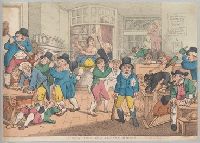
A scene in a crowded coffee house with a mad dog on a table and terrified customers scrambling for cover. On the wall, a broadside titled: For the brasiles the Cerberuse Capn. Popitner ... bruden ...
Description:
Not in the Catalogue of prints and drawings in the British Museum. Division I, political and personal satires. and Title etched below image.
Publisher:
Pubd. March 20th, 1809, by Thos. Rowlandson, No 1. James Street, Adelphi, London,