Goddard, George H. (George Henry), 1817-1906, cartographer
Published / Created:
[1855?]
Call Number:
BrSides Zc72 855gn
Image Count:
2
Resource Type:
cartographic image
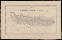
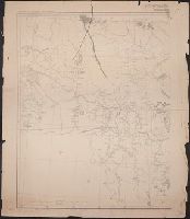
Description:
BEIN Broadsides Zc72 855gn: Mounted on linen. Autograph: H.W. Turner. Withdrawn stamp: Map Collection, University of California Library., Oriented with north toward upper right., Relief shown by hachures., Shows settlements, roads, ditches, flumes, etc., Includes table of distances., and Coordinates not present on map and are approximated.
Publisher:
Lith of Britton & Rey
Subject (Geographic):
California, Calaveras County, Calaveras County (Calif.), Mokelumne Hill Canal (Calif.), and Calaveras County.
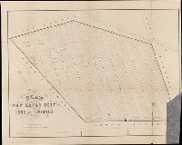
BEIN 766 N46 1859: Dissected and mounted on linen., BEIN Roll Map 485: Imperfect: mutilated, brittle, and chipped. Mounted on linen with wooden strip at top., Relief shown by hachures., "Scale 300 ft. to an inch.", Coordinates not present on map and are approximated., and Includes 15 vignettes and inset map "A plan of the town of New Haven with all the buildings in 1748."
Publisher:
Published by Eneas Smith and W.H. Rease's Lithographic Establishment, N.E. cor. 4th & Chestnut St.
BEIN Covers 59 1855: Autograph on verso: Geo. Drummond, Madras., Covers southern half of India: N 25°--N 8° and E 73°--E 86°., "Compiled and drawn by J.S. Harvey, Qr. Mr. Genls. Office, Madras"--lower left corner., and Case title: Madras Presidency.
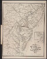
United States. War Department. Corps of Engineers, cartographer, publisher
Published / Created:
[1881]
Call Number:
831 1881A
Image Count:
2
Resource Type:
cartographic image
Description:
Relief shown by hachures., Scale "1 inch - 12 miles.", Shows battle sites and military expeditions, with dates., Westernmost sheet: "2nd edition May 1875 compiled under direction of Capt. Wm. Ludlow, Corps of Engrs."--Lower left margin., and In upper left margin: Brig. Genl. A.A. Humphreys, Chief of Engineers.
United States. War Department. Corps of Engineers, cartographer, publisher
Published / Created:
[1875?]
Call Number:
831 1875
Image Count:
1
Resource Type:
cartographic image
Description:
BEIN 831 1875: Imperfect: eastern sheet wanting; western sheet chipped. Inscription below edition statement: Lieut. [?] F. Eng., 5th Infty. Inscription on verso: Capt. Ludlow's map, 1875, sheet no. 1., Relief shown by hachures., Scale "1 inch - 12 miles.", Shows battle sites and military expeditions, with dates., and In upper left margin: Brig. Genl. A.A. Humphreys, Chief of Engineers.
Relief shown pictorially., North oriented down., Bar scale given in unidenified units., Coordinates not present on map and are approximated., Includes index of colleges, buildings, and streets., and Insets: view of Oxforde and a map of Oxfordshire with bar scale in miles.
BEIN BrSides Folio 2014 10: Imperfect: torn and mutilated, with lower right corner missing., "Area 18 acres.", and Removed from: History of the city burial ground, in New Haven, together with the names of the owners of the lots therein (1863).
Publisher:
publisher not identified and Lith. by Punderson & Crisand
BEIN Folio G1244 N48 S26 1973: Imperfect: sheets 351-352 wanting. Disbound., Title from accompanying letter., Unpublished. Available upon request at the Sanborn Map Company, Inc., Also referred to by Publisher as Atlas of New Haven, Connecticut., and Contains information on population, prevailing winds, water facilities and fire department.
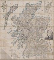
Scotland drawn and engraved from a series of angles and astronomical observations
Description:
Title from cartouche., Engraved throughout., Relief shown by contour lines and pictures., Scale of miles 69 1/2 to a degree., Another imprint: "Published according to Act of Parliament Jan. 1st. 1789 by John Ainslie ... and William Faden ..." at bottom of sheet., Inset maps: "Shetland Islands laid down upon a less scale than the map ... "; "A Map of the Orkney Islands ...", Distance tables and lists of heights of hills and roads from Edinburgh to London., Edinburgh meridian, with note of degrees from Greenwich., Title cartouche shows men fishing and herding cattle, with sheep goats and foliage., Six compass roses., This issue not in Chubb, T. Printed maps in the atlases of Great Britain and Ireland., and Scotland.
Publisher:
Printed and sold by the proprietor Thomas Brown, North Bridge Street, Edinburgh and Publish'd according to Act of Parliament with improvements till 1800 by Thomas Brown ... Edinburgh and William Faden ... London
Subject (Geographic):
Scotland, Orkney (Scotland), Shetland (Scotland), Scotland., Orkney., and Shetland.