From A. Fullarton & Co.'s Royal illustrated atlas of modern geography. London; Edinburgh: A. Fullarton and Co., [1872?]., Imperfect: brittle and chipped. Sheet measures 59 x 46 cm. Manuscript annotations on verso. Cross Collection no. 83., and Relief shown by hachures.
Publisher:
A. Fullarton & Co.,
Subject (Geographic):
Europe, Eastern--Maps. and Russia--Maps.
Subject (Name):
A. Fullarton & Co. Royal illustrated atlas of modern geography.
Cross collection no. 81., Hand colored., Includes inset map of Southeast Alaska: "New Norfolk.", Prime meridien: Greenwich., Relief shown by hachures and 1 spot height., and This map from "The royal illustrated atlas of modern geography."
Publisher:
A. Fullarton & Co.,
Subject (Geographic):
Alaska--Maps--19th century., Arctic regions--Maps--19th century., Asiatic Russia--Maps--19th century., China--Maps--19th century., East Asia--Maps--19th century., and Russia--Maps--19th century.
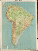
Bartholomew's world layered series, John Bartholomew and Son. Bartholomew's world layered series., and Map of South America, in layer coloring with roads and other features
Description:
Back panel lists titles in Bartholomew's General World Series., Includes 1 inset map of the Galapagos Islands, at the same scale., and Relief shown by shading and spot heights.
Automobile Association (Great Britain). Touring Dept Edinburgh Geographical Institute John Bartholomew and Son
Published / Created:
[19--?]
Call Number:
3212 1900
Container / Volume:
BRBL_00055
Image Count:
1
Resource Type:
Maps, Atlases & Globes
Alternative Title:
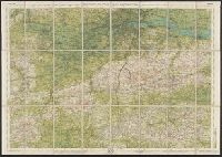
Bartholomew's half-inch to mile map of England & Wales ; sheet 30 and John Bartholomew and Son. Bartholomew's half-inch to mile map of England & Wales ; sheet 30.
Description:
Relief shown by contours, gradient tints and spot heights.
Publisher:
Edinburgh Geographical Institute, and John Bartholomew :
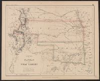
"Entered in Sta. Hall, London - & according to act of Congress in the year 1857 by H.D. Rogers, in the Clerks Office of the District Court of Massachusetts.", I, In top margin: Atlas of United States &c., 12., and Shows proposed Pacific Railway routes in purple.
Publisher:
John Murray ; and W. & A.K. Johnston,
Subject (Geographic):
Colorado--Maps, Indian Territory--Maps, and Kansas--Maps
Subject (Name):
John Murray (Firm), Johnston, Alexander Keith, 1804-1871, and Rogers, Henry D. (Henry Darwin), 1808-1866. Atlas of the United States of North America, Canada, New Brunswick, Nova Scotia, Newfoundland, Mexico, Central America, Cuba and Ja
"Entered in Sta. Hall London. ̲̲& according to act of Congress, in the year 1857 by H.D. Rogers in the Clerks Office of the District Court of Massachusetts." and Appears in Rogers, H.D. and Johnston, A.K. Atlas of the United States of North America. London: J. Murray, 1857.
Publisher:
John Murray ; and W. & A.K. Johnston,
Subject (Geographic):
Nebraska--Maps
Subject (Name):
John Murray (Firm), Johnston, Alexander Keith, 1804-1871, Rogers, Henry D. (Henry Darwin), 1808-1866. Atlas of the United States of North America, Canada ... New Foundland, Mexico, Central America, Cuba, and Jamaica .., and W.