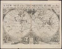
"Dedicated to His Highness William Duke of Gloucester.", "Delin. M. Burghers sculpt. Univ. Oxon.", Cross collection no. 32., Plate mark 1 was added below the dedication plinth for the editions in 1726 and 1738--Cf. Shirley., and Scale measured at center of hemisphere.
Publisher:
s.n.,
Subject (Name):
Burghers, M and Wells, Edward, 1667-1727. New sett of maps both of antient and present geography
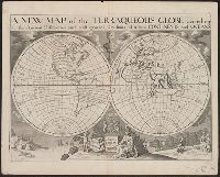
"Dedicated to His Highness William Duke of Gloucester.", "Delin. M. Burghers sculpt. Univ. Oxon.", Appeared in Wells' New sett of maps both of antient and present geography., Cross collection no. 31., Double hemisphere on sheet in outline, with rivers, capes and island marked but few other place names., Plate mark 2 was added below the dedication plinth for the editions in 1726 and 1738--Cf. Shirley., Scale measured at center of hemisphere., and Slip pasted to verso of map: Property of Andrew Arthur Benton, New York, N.Y.
Publisher:
s.n.,
Subject (Name):
Benton, Andrew Arthur--Ownership, Burghers, M, and Wells, Edward, 1667-1727. New sett of maps both of antient and present geography
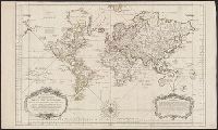
"Most humbly inscribed to his Royal Highness George Prince of Wales", Double hemispherical map of the world with relief shown pictorially., Mounted on stiff cardboard. Cross collection no. 30A., and Probably from Senex's A new general atlas. London: D. Browne, 1721.
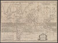
Cross collection no. 43. and Map of the world showing wind patterns and incomplete outline of Australia and New Zealand. Also shows time differences and some relief in hill shading.
At bottom of the title cartouche: "Par le S.r Bellin, Ingenieur de la Marine and New Guinea shown joined to New Holland; Dampier's Strait marked. Bellin traces the 'hypothetical' coast of New Holland which was object of speculation before Cook's discoveries.
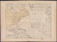
"Longitude w. from London.", "Plate III. The dominions ceded by France & Spain to Great Britain are colored with a feint red.", Accompanied by 2 leaves intended to be hinged to the margin as overlays to North America: Plate I. Clai, and Relief shown pictorially.
Subject (Geographic):
Atlantic Ocean--Maps--Early works to 1800 and North America--Maps--Early works to 1800
Appears in Bünting's Itinerarium Sacrae Scripturae., In top left margin: 4., In top right margin: 5., Signature mark: ij., and The world is portrayed as a clover leaf.
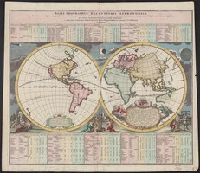
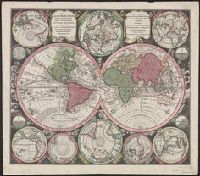
Appeared in author's Atlas novus ... [1742 or later]., Ms. note on verso: Globus terrestris III. Cross collection no. 36., Scale measured at center of hemisphere., Showing two principal terrestrial hemispheres and eight subsidiary hemispheres on various projections; four smaller astronomical diagrams., and Shows California as an island.