"European Magazine" in upper right., Coordinates not present on map and are approximated., Imperfect: left portion of map and upper right portion of map wanting, with some loss of text., Relief shown pictorially., and Watermark.
Publisher:
Published April 1, 1782, by I. Fielding, Pater noster Row, J. Sewell, Cornhill, and J. Debrett, Piccadilly,
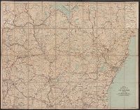
Automobile map of New Hampshire, central and Automobile map of New Hampshire, south
Description:
Automobile map of New Hampshire, south, No. 13 -- Automobile map of New Hampshire central, No. 14., Maps mounted on cloth backing., Relief shown by hachures., Shows southeastern New Hampshire and some of Maine and Massachusetts, from Saco, Me. in the northeast to Newbury, Mass. in the southeast and Orange, N.H. in the northwest to Rindge, N.H. in the southwest., and Title from panel.
LVIII., Monument record sheet LVIII., and Part of Monument record sheet LVIII :
Description:
Accompanied, as issued, by Monument record sheet LVIII. "Gift of Sarah Day Woodward"--Manuscript note. and At head of title: Part of Monument record sheet LVIII.
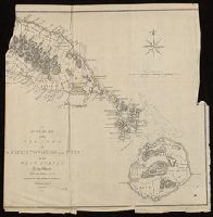
Britannia prout divisa fuit temporibus Anglo-Saxonum praesertim durante illorum heptarchia.
Description:
Border illustrations include seven Anglo-Saxon kings on the left; the conversion to Christianity of a further seven are depicted on the right., Manuscript number in upper left corner: 7., Relief shown pictorially., and Shows kingdom boundaries, rivers, settlements and shields.
Society for the Diffusion of Useful Knowledge (Great Britain)
Published / Created:
Novr. 1842.
Call Number:
BrSides Folio 2019 94
Image Count:
1
Resource Type:
Maps, Atlases & Globes
Description:
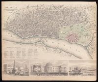
Coordinates not present on map and are approximated., Includes "References to the public buildings, churches & chapels" and illustrations of Writers Buildings, Government House and Esplanade Row., and Oriented with north to lower left.
Mitchell, S. Augustus (Samuel Augustus), 1792-1868
Published / Created:
1847
Call Number:
BrSides 2017 63
Image Count:
1
Resource Type:
Maps, Atlases & Globes
Alternative Title:
Plan of the principal floor of the Capitol.
Description:
"Entered according to Act of Congress, in the year 1846, by H.N. Burroughs, in the Clerk's Office of the District Court of the Eastern District of Pennsylvania.", At lower right corner: 16., Coordinates not present on map and are approximated., Includes "Plan of the principal floor of the Capitol" and index to points of interest., Label "Columbia College" on top border of map., and Shows wards, built-up areas, and major buildings. Also covers Georgetown.
Publisher:
Published by S. Augustus Mitchell, n.e. corner of Market & 7th Streets,
Subject (Geographic):
Georgetown (Washington, D.C.)--Maps., Washington (D.C.)--Administrative and political divisions--Maps., and Washington, D.C.--Maps
Subject (Name):
Burroughs, H. N.
Subject (Topic):
Administrative and political divisions--Maps and United States Capitol (Washington, D.C.)--Designs and plans.