Skip to search
Skip to main content
Skip to first result
Search
You Searched For
Repository
Beinecke Rare Book and Manuscript Library
Format
cartographic
Language
Japanese
New Search
Search Results
Published / Created:
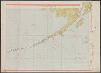
Shōwa 18 [1943] and 昭和 18 [1943]
Call Number:
739CBF 1945 2
Container / Volume:
BRBL_00391
Image Count:
1
Resource Type:
Maps, Atlases & Globes
Alternative Title:
Japan. 陸地測量部., Japan. 陸軍. 参謀本部., and アンカレッヂ--ダッチハーバー / 陸地測量部, 参謀本部.
Description:
"Kōkūzu gunji himitsu (senchi ni arite wa 'bugaihi' to su) ", "Sanbyakuman-bun-no-ichi Han Taiheiyō yochizu jūrokugō kōkūzu sozu.", "航空圖軍事祕密 (戰地ニ在リテハ「部外祕」トス).", and Publication date of 1943 infered by date for the magnetic declination information on map.
Publisher:
s.n.],
Subject (Geographic):
Alaska--Maps
Subject (Name):
Japan. Rikuchi Sokuryōbu and Japan. Rikugun. Sanbō Honbu
Subject (Topic):
Aeronautical charts--Alaska
Found in:
Beinecke Rare Book and Manuscript Library > Ankarejji--Datch Hābā / Rikuchi Sokuryōbu, Sanbō Honbu.
Published / Created:
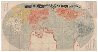
[1700]
Call Number:
11 1700E
Container / Volume:
BRBL_00004
Image Count:
1
Resource Type:
Maps, Atlases & Globes
Description:
In Japanese. and Preliminary record.
Subject (Geographic):
World--Maps--Early works to 1800
Found in:
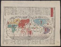
Beinecke Rare Book and Manuscript Library > Bankoku Chikyu Saiken Zenzu. [A Complete Guide to All the Countries of the Globe].
Published / Created:
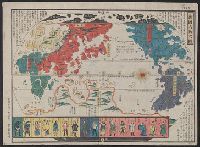
[1825]
Call Number:
11 1825
Container / Volume:
BRBL_00007
Image Count:
1
Resource Type:
Maps, Atlases & Globes
Description:
Map in Japanese. Originally issued as one of the earliest Nagasaki prints in mid-eighteenth century. and Preliminary record.
Publisher:
Published by Eijudo, Imakajiyamachi,
Subject (Geographic):
World--maps
Found in:
Beinecke Rare Book and Manuscript Library > Bankoku Jinbutsu no Dzu. [Picture of the World and its People].
Creator:
Published / Created:
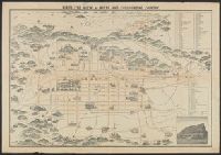
[19--?]
Call Number:
57AM K99 1920
Container / Volume:
BRBL_00305
Image Count:
2
Resource Type:
Maps, Atlases & Globes
Description:
Bird's eye view., In Japanese and English., Includes a view of a temple, index and legend., Lithograph., and Oriented with north to the left.
Publisher:
K. Kawakami,
Subject (Geographic):
Kyoto (Japan)--Maps
Found in:
Beinecke Rare Book and Manuscript Library > Bird's eye view of Kioto and surrounding country / Y. Shimidzu.
Published / Created:
[1815]
Call Number:
11 1815
Container / Volume:
BRBL_00007
Image Count:
1
Resource Type:
Maps, Atlases & Globes
Description:
Preliminary record.
Subject (Geographic):
World--maps
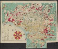
Found in:
Beinecke Rare Book and Manuscript Library > Chikkyu Bankoku Sankai Yochi Zen Zuzetsu. [Descriptive Map of the Globe with all countries, Lands, and Seas]. Description by Mito Sekisui Chogenshu. Copy of Sekisui's famous world map.
Published / Created:
1841
Call Number:
57 1841
Container / Volume:
BRBL_00301
Image Count:
2
Resource Type:
Maps, Atlases & Globes
Subject (Geographic):
Japan--Maps
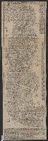
Found in:
Beinecke Rare Book and Manuscript Library > Dai Nihon Dochu Hayabiki Saiken no Dzu [Guide to Japan].
Published / Created:
1871
Call Number:
57 T578 1871
Container / Volume:
BRBL_00304
Image Count:
1
Resource Type:
Maps, Atlases & Globes
Description:
Preliminary record.
Subject (Geographic):
Tokyo (Japan)--Maps
Found in:
Beinecke Rare Book and Manuscript Library > Eifuku Tokyo go-ezu [Illustrated map of Tokyo].
Published / Created:
1830?]
Call Number:
57 1830
Container / Volume:
BRBL_00301
Image Count:
3
Resource Type:
Maps, Atlases & Globes
Subject (Geographic):
Japan--Maps
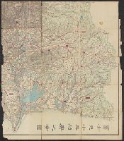
Found in:
Beinecke Rare Book and Manuscript Library > Fuji-mi jūsan-shū yochi zenzu [Map of the 13 provinces around Mt. Fuji].
Creator:
Published / Created:
1912-15.
Call Number:
57 1915
Container / Volume:
BRBL_00302
Image Count:
24
Resource Type:
Maps, Atlases & Globes
Alternative Title:
Topographical map, Division I-V
Description:
Black-and-white maps with water features shown in blue., Each division mapped in 4 to 6 sheets., Imperfect: Division I wanting., Relief shown by contours and spot heights., and Title, place names and legend in English; sheet information and imprint also in Japanese.
Publisher:
Imperial Geological Survey of Japan,
Subject (Geographic):
Japan--Maps
Found in:
Beinecke Rare Book and Manuscript Library > Imperial Geological Survey of Japan topographical map : Division I-[V].
Published / Created:
[1600?]
Call Number:
57 1600
Container / Volume:
BRBL_00300
Image Count:
4
Resource Type:
Maps, Atlases & Globes
Subject (Geographic):
Japan--Maps--Early works to 1800
Found in:
Beinecke Rare Book and Manuscript Library > Japan.
Branch:v1.62.0 ,Deployed:2024-06-26T09:57:02-04:00