Mounted on linen. Ms. notes in red: changes in magnetic variations dated 1871, locations of bells, buoys, lights, and whistles, "N.B. The fog trumpet at Sambro Island has been discontinued. Guns will be fired from the island in answer to signals from ship
La Pérouse, Jean-François de Galaup, comte de, 1741-1788
Published / Created:
1798
Call Number:
23 1798A
Container / Volume:
BRBL_00019
Image Count:
1
Resource Type:
Maps, Atlases & Globes
Alternative Title:
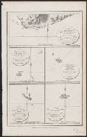
Part of the Island of Botol, Plan of Isle Dagelet, Plan of the Island Hoapinsu and the surrounding Islets, and Plan of the Island of Kumi
Description:
"No. 45.", Five maps on one sheet., From Charts and plates to La Perouse's Voyage. [London] : G.G. Robinson, 1798., Hand col. Sheet measures 42.4 x 26.5 cm., Neele, sculp., and Relief shown by spot heights, form lines, and soundings.
Great Britain. Hydrographic Department, cartographer
Published / Created:
March 23rd 1846.
Call Number:
BrSides 2019 97
Image Count:
1
Resource Type:
Maps, Atlases & Globes
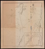
Alternative Title:
Port Adelaide and Holdfast Bay and St. Vincent Gulf, Port Adelaide and Holdfast Bay
Description:
"1752" in lower right corner., Coordinates not present on map and are approximated., From John Lort Stokes's Discoveries in Australia (1846)., Imperfect: mutilated., Inset, Nautical chart of Port Adelaide and Holdfast Bay in South Australia with relief shown by hachures and spot heights. Depth shown by bathymetric soundings., and Port Adelaide enlarged. Scale approximately1: 50,000.
Publisher:
Published according to Act of Parliament at the Hydrographic Office of the Admiralty,
Subject (Geographic):
Brighton (S.A.)--Maps. and Port Adelaide Region (S.A.)--Maps.
Subject (Name):
Bate, R. B. (Robert Brettell), bookseller, J. & C. Walker (Firm), engraver, and Stokes, John Lort, 1811-1885. Discoveries in Australia.
Subject (Topic):
Nautical charts--Australia--Holdfast Bay (S.A. : Bay) and Nautical charts--Australia--Port Adelaide Region (S.A.)
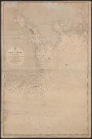
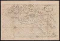
From Pashasheeboo Pt. to Magpie Bay and Pashasheeboo Pt. to Magpie Bay
Description:
"J. & C. Walker, Sculpt.", "Large corrections 1861.", "Published according to Act of Parliament at the Hydrographical Office of the Admiralty, Decr. 1st. 1837.", In lower left margin: "1279", in lower right margin: "306.", and Relief shown by hachures and spot he
Publisher:
Hydrographical Office of the Admiralty,
Subject (Geographic):
Saint Lawrence, Gulf of--Navigation
Subject (Name):
Great Britain. Hydrographic Office and J. & C. Walker (Firm)
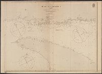
"Emanl. Bowen sculp." and Insets: Plan of the Harbours of Ferrol and the Groyne -- Plan of St Sebastian -- Plan of Barcelona -- Plan of the Bay and City of Cadiz -- Plan of
Publisher:
T. Jefferys,
Subject (Name):
Bowen, Emanuel, d. 1767
Subject (Topic):
Coasts--Europe, Western--Maps--Early works to 1800 and Nautical charts--Europe, Western--Early works to 1800
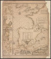
English pilot. Book 4. and Virginia, Maryland, Pennsylvania, east & west New Jersey
Description:
Appears in various eds. of The English pilot, Book 4., Depths shown by soundings., Mounted on linen. Sheet measures 59.1 x 87.2 cm. Cross Collection no. 191., Nautical chart of the coast from New York Bay to Chesapeake Bay,, and Oriented with north to the right.
Publisher:
Sold by William Mount & Tho. Page, Tower Hill,
Subject (Geographic):
Middle Atlantic States--Maps--Early works to 1800
Subject (Name):
Mount, William, d. 1769, bookseller and Page, Thomas, d. 1733, bookseller
Subject (Topic):
Coasts--Middle Atlantic States--Maps--Early works to 1800, Nautical charts--Atlantic Coast (Middle Atlantic States)--Early works to 1800, and Nautical charts--Middle Atlantic States--Early works to 1800