Skip to search
Skip to main content
Skip to first result
Search
You Searched For
Resource Type
Maps, Atlases & Globes
Language
Japanese
New Search
Search Results
Creator:
Published / Created:
1912-15.
Call Number:
57 1915
Container / Volume:
BRBL_00302
Image Count:
24
Resource Type:
Maps, Atlases & Globes
Alternative Title:
Topographical map, Division I-V
Description:
Black-and-white maps with water features shown in blue., Each division mapped in 4 to 6 sheets., Imperfect: Division I wanting., Relief shown by contours and spot heights., and Title, place names and legend in English; sheet information and imprint also in Japanese.
Publisher:
Imperial Geological Survey of Japan,
Subject (Geographic):
Japan--Maps
Found in:
Beinecke Rare Book and Manuscript Library > Imperial Geological Survey of Japan topographical map : Division I-[V].
Creator:
Published / Created:
[1914?]
Call Number:
13am 1914
Container / Volume:
BRBL_00011
Image Count:
1
Resource Type:
Maps, Atlases & Globes
Alternative Title:
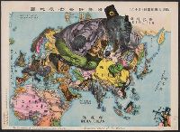
Illustration of the Great European War.
Description:
"A humoros atlas of the world." and In Japanese and English.
Subject (Geographic):
Eastern Hemisphere--Maps
Subject (Topic):
World War, 1914-1918--Maps
Found in:
Beinecke Rare Book and Manuscript Library > The illustration of the Graet European War. No. 16.
Published / Created:
[1833] and 天保 4 年.
Call Number:
BrSides 2018 136
Image Count:
1
Resource Type:
Maps, Atlases & Globes
Description:
Ikeda Tōritei, editor; Nakamura Yūrakusai, cartographer, Nishihara Jūbei, engraver., Imperfect: torn along fold, with some loss of text. Accompanied by paper envelope with printed title "Map of Kioto at Tenpai period" and manuscript note "Kyoto, 1833.", North oriented towards the left., Relief shown pictorially., Title devised by cataloger., and 池田東籬亭, 考正; 中村有楽斎, 画図; 西原十兵衛, 彫.
Publisher:
Takehara Kōbei,
Subject (Geographic):
Kyōto (Japan)--Maps.
Subject (Topic):
East Asia Library Special Collections.
Found in:
Beinecke Rare Book and Manuscript Library > [Map of Kyoto] [cartographic material].
Published / Created:
1945?]
Call Number:
281CBF 1945A
Container / Volume:
BRBL_00026
Image Count:
4
Resource Type:
Maps, Atlases & Globes
Description:
In Japanese. and Title supplied by cataloger.
Subject (Geographic):
Luzon (Philippines)--Maps
Found in:
Beinecke Rare Book and Manuscript Library > [4 maps of Luzon, Philippines, in Japanese.]
Published / Created:
[1600?]
Call Number:
57 1600
Container / Volume:
BRBL_00300
Image Count:
4
Resource Type:
Maps, Atlases & Globes
Subject (Geographic):
Japan--Maps--Early works to 1800
Found in:
Beinecke Rare Book and Manuscript Library > Japan.
Creator:
Published / Created:
[19--?]
Call Number:
57AM K99 1920
Container / Volume:
BRBL_00305
Image Count:
2
Resource Type:
Maps, Atlases & Globes
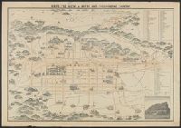
Description:
Bird's eye view., In Japanese and English., Includes a view of a temple, index and legend., Lithograph., and Oriented with north to the left.
Publisher:
K. Kawakami,
Subject (Geographic):
Kyoto (Japan)--Maps
Found in:
Beinecke Rare Book and Manuscript Library > Bird's eye view of Kioto and surrounding country / Y. Shimidzu.
Published / Created:
1841
Call Number:
57 1841
Container / Volume:
BRBL_00301
Image Count:
2
Resource Type:
Maps, Atlases & Globes
Subject (Geographic):
Japan--Maps
Found in:
Beinecke Rare Book and Manuscript Library > Dai Nihon Dochu Hayabiki Saiken no Dzu [Guide to Japan].
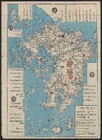
Published / Created:
1813
Call Number:
573 1813A
Container / Volume:
BRBL_00310
Image Count:
2
Resource Type:
Maps, Atlases & Globes
Publisher:
Bummendō,
Subject (Geographic):
Kyūshū Region (Japan)--Maps
Found in:
Beinecke Rare Book and Manuscript Library > Kyūshū no zu [Map of Kyūshū Island, Japan].
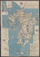
Published / Created:
1813
Call Number:
573 1813
Container / Volume:
BRBL_00310
Image Count:
2
Resource Type:
Maps, Atlases & Globes
Publisher:
Bummendō,
Subject (Geographic):
Kyūshū Region (Japan)--Maps
Found in:
Beinecke Rare Book and Manuscript Library > Kyūshū no zu [Map of Kyūshū Island, Japan].
Published / Created:
1864
Call Number:
57 K99 1864
Container / Volume:
BRBL_00303
Image Count:
2
Resource Type:
Maps, Atlases & Globes
Description:
Orig. publ. 1810.
Subject (Geographic):
Kyoto (Japan)--Maps
Found in:
Beinecke Rare Book and Manuscript Library > Kyō meisho michi go-shiori nozu [Illustrated guide to the streets of Kyoto] At the head of lith: Genji Kaisei [i.e. rev 1864].
Branch:v1.64.0 ,Deployed:2024-09-11T10:25:40-04:00