Search
You Searched For
Search Results
- Creator:
- Topografische Inrichting (Jakarta, Indonesia)
- Published / Created:
- 1912
- Call Number:
- 27251 1912
- Container / Volume:
- BRBL_00023B
- Image Count:
- 1
- Resource Type:
- Maps, Atlases & Globes
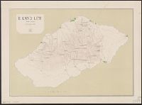
- Alternative Title:
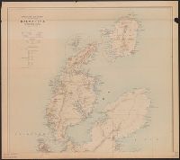
- Leti
- Description:
- Relief shown by contours and spot heights. and Surveyed by A. Lichtenberg.
- Publisher:
- Topographische Inrichting,
- Subject (Geographic):
- Leti Island (Maluku, Indonesia)--Maps
- Subject (Name):
- Lichtenberg, A
- Found in:
- Beinecke Rare Book and Manuscript Library > Eiland Leti / Topographische Inrichting ; Opgenomen door den opnemer A. Lichtenberg.
- Creator:
- Topografische Inrichting (Jakarta, Indonesia)
- Published / Created:
- 1915
- Call Number:
- 2717 1915
- Container / Volume:
- BRBL_00023B
- Image Count:
- 1
- Resource Type:
- Maps, Atlases & Globes
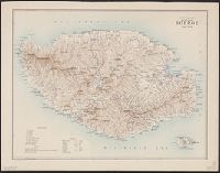
- Alternative Title:
- Boeroe
- Description:
- Relief shown by hachers and spot heights.
- Publisher:
- Topografische Inrichting,
- Subject (Geographic):
- Buru Island (Maluku, Indonesia)--Maps
- Found in:
- Beinecke Rare Book and Manuscript Library > Schetskaart van het eiland Boeroe.
- Creator:
- Topografische Inrichting (Jakarta, Indonesia)
- Published / Created:
- 1914
- Call Number:
- 2716 1914
- Container / Volume:
- BRBL_00023B
- Image Count:
- 2
- Resource Type:
- Maps, Atlases & Globes
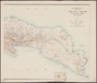
- Alternative Title:
- Eiland Ceram en omliggende eilanden
- Description:
- Ms. annotations. and Relief shown by form lines and spot heights.
- Publisher:
- Topografische Inrichting,
- Subject (Geographic):
- Ceram Island (Indonesia)--Maps
- Found in:
- Beinecke Rare Book and Manuscript Library > Schetskaart van het eiland Ceram en omliggende eilanden / Topografische dienst.
- Creator:
- Topografische Inrichting (Jakarta, Indonesia)
- Published / Created:
- 1911
- Call Number:
- 2725 1911
- Container / Volume:
- BRBL_00023B
- Image Count:
- 1
- Resource Type:
- Maps, Atlases & Globes
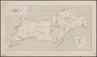
- Alternative Title:
- Eiland Wetar
- Publisher:
- Topografische Inrichting,
- Subject (Geographic):
- Wetar Island (Indonesia)--Maps
- Found in:
- Beinecke Rare Book and Manuscript Library > Schetskaart van het eiland Wetar / Topografische Inrichting.
- Creator:
- Topografische Inrichting (Jakarta, Indonesia)
- Published / Created:
- 1918
- Call Number:
- 2714 1918
- Container / Volume:
- BRBL_00023B
- Image Count:
- 2
- Resource Type:
- Maps, Atlases & Globes
- Alternative Title:
- Halmahera en omliggende eilanden
- Description:
- Ms. annotations.
- Publisher:
- Topographische Inrichting,
- Subject (Geographic):
- Halmahera (Indonesia)--Maps
- Found in:
- Beinecke Rare Book and Manuscript Library > Voorloopige schetskaart van het eiland Halmahera en omliggende eilanden / [door de] Topographische Inrichting, Batavia.