At the beginning of the Ch'ing Dynasty (1644), the island became a defense against remnant Ming forces that had fled to Taiwan. During the second Opium War, Hai-Ta'n was occupied by British and French forces.
Publisher:
[publisher not identified],
Subject (Geographic):
Haitan Dao (China)--Maps.
Subject (Topic):
Chinese rare maps. and Islands--China--Fujian Sheng--Maps.
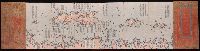
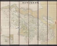
"Capital edition of a complete map (of the world based on) astronomy.", Ancillary maps of the world: Hai kuo wen chien lu szu hai tsung tʻu -- Nei ban shan hai tian wen quan tu., Includes notes., Relief shown pictorially., Text in Chinese, transliterated., and Woo
Institut ėtnografii imeni N.N. Miklukho-Maklai︠a︡ Институт этнографии имени Н.Н. Миклухо-Маклая
Published / Created:
1959
Call Number:
56ed 1959
Container / Volume:
BRBL_00298
Image Count:
2
Resource Type:
Maps, Atlases & Globes
Alternative Title:
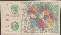
Naselenie Kitai︠a︡, MNR i Korei. and Карта народов Китая, МНР и Кореи / составлена в 1958 г. Институтом этнографии имени Н.Н. Миклухо-Маклая Академии наук СССР и Научно-редакционной картосоставительской частью ГУГК ; под общим руководством П.Е. Терлецкого ; а
Description:
Accompanied by explanatory pamphlet with title: Naselenie Kitai︠a︡, MNR i Korei by S.I. Bruk., Accompanied by explanatory pamphlet with title: Население Китая, МНР и Кореи by S.I. Bruk., Legend also in Chinese., and Title from envelope in which issued.
Publisher:
Glavnoe upravlenie geodezii i kartografii MVD SSSR :, Institut ėtnografii imeni N.N. Miklukho-Maklai︠a︡ Akademii nauk SSSR,, Главное управление геодезии и картографии МВД СССР :, and Институт этнографии имени Н.Н. Миклухо-Маклая Академии наук СССР,
Subject (Geographic):
China--Maps, Korea--Maps, and Mongolia--Maps
Subject (Name):
Bruk, Solomon Ilʹich, Soviet Union. Glavnoe upravlenie geodezii i kartografii, Soviet Union. Главное управление геодезии и картографии, Terlet︠s︡kiĭ, P. E, Брук, Соломон Ильич, and Терлецкий, П. Е
Subject (Topic):
Ethnology--China--Maps, Ethnology--Korea--Maps, and Ethnology--Mongolia--Maps
Covers all of Shandong Province and southern Hebei Province., In German and Chinese., Relief shown by shading on some sheets., and Sheets L14. and K14 only.
Publisher:
Kartogr. Abteilung der Kgl. Preuss. Landesaufnahme,
Subject (Geographic):
Beijing Region (China)--Maps, Hebei Sheng (China), Shandong Sheng (China)--Maps, and Tianjin Region (China)--Maps
"咸豐庚申降婁海東重刊", "治理曆法極西南懷仁立法", Based on the world map of Joannes Blaeu., Includes illus. and text., Relief shown pictorially., Reprint., Shows the world in two hemispheres., and Wood block prints.
Publisher:
[publisher not identified],
Subject (Name):
Blaeu, Joan, 1596-1673.
Subject (Topic):
Chinese rare maps. and World maps--Early works to 1800.
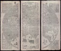
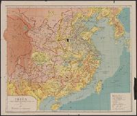
Map of China, the eighteen provinces and Shi ba sheng : [Zhongguo]
Description:
"Transliteratred by M. Kennelly, S.J. Sicawei College.", DLC, Gift of Mr. Walter J Swingle, July 23, 1952., LC copy sectioned into 2 and mounted on cloth backing., and Relief shown by gradient tints.
Publisher:
Sold at Tusewei Press,
Subject (Geographic):
China--Administrative and political divisions--Maps
Great Britain. War Office. General Staff. Geographical Section
Published / Created:
1905
Call Number:
5616 1905
Container / Volume:
BRBL_00299
Image Count:
1
Resource Type:
Maps, Atlases & Globes
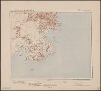
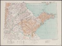
Alternative Title:
GSGS (Series) ; 1936., Province of Shandong, and T.S.G.S. ; no. 1936
Description:
Includes an English, Chinese explanation and a list of sources of information., Map of the Chinese province Shandong showing province and colonial boundaries, transportation, communications, ground and water features, missions and populated places., and Relief
Publisher:
Reproduced and printed for the Topographical Section, General Staff, at the Ordnance Survey Office,
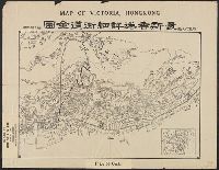
Map of Victoria, Hong Kong, Xianggang xiang xi jie dao quan tu, 最新香港詳細街道全圖 = Map of Victoria, Hong Kong., and 香港詳細街道全圖
Description:
"遊覽之必需.", In Chinese and English., Includes 1 inserted map: Xinjie quan tu., Includes 1 insertedt map: 新界全圖., and Showing streets and interesting places in Hong Kong Island.