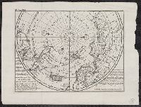
"Vol. I. p. 805" in upper left corner., Appears in: Atlas minor, or, A new and curious set of sixty-two maps. [London] : Printed for Tho: Bowles next ye Chapter House in St. Pauls Church Yard, & John Bowles at the Black Horse in Cornhill ..., [1736?], Cross collection no. 53., From: Thomas Salmon's Modern history. London : Printed for Messrs. Bettesworth and Hitch, J. Clarke, S. Birt, Tho. Wotton, and J. Shuckburgh, and T. Osborne, 1739., Includes text., and Relief shown pictorially.
Publisher:
Printed for Tho. Bowles next the Chapter house in St. Pauls church yard & Iohn Bowles at the Black Horse in Cornhill,
Subject (Geographic):
Arctic Regions--Maps--Early works to 1800 and North Pole--Maps--Early works to 1800
Subject (Name):
Bowles, John, 1701-1779, bookseller, Bowles, Thomas, -1767, bookseller, and Salmon, Thomas, 1679-1767. Modern history
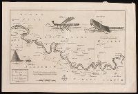
"No. 58" at bottom left; "Plate XLII. Vol. 2 page 159" at bottom right., Coordinates not present on map and are approximated., Relief shown pictorially and by soundings., Shows topography, waterways, routes, settlements., and Watermark.
Publisher:
[publisher not identified],
Subject (Geographic):
Gambia River--Maps--Early works to 1800. and Gambia--Maps--Early works to 1800.
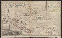
Insets: View of the City of Mexico with index, La Vera Cruz Harbor, Havana Harbor, The bay of Porto Bella, St. Agustin Harbor, Cartagena. and This edition apparently later than *85 1708A, as it has imprint Printed for Thomas Bowels ... and Ion Bowels ... [and] Sold by H. Moll and by I. Ring ...
Insets: View of the City of Mexico with index, La Vera Cruz Harbor, Havana Harbor, The bay of Porto Bella, St. Agustin Harbor, Cartagena. and This edition apparently later than *85 1708A, as it has imprint Printed for Thomas Bowels ... and Ion Bowels ... [and] Sold by H. Moll and by I. Ring ...
Includes eastern Connecticut ; Massachusetts as far north as Boston, including Cape Cod, Martha's Vineyard, and Nantucket ; and the eastern end of Long Island.
Alternative Title:
Colony of Rhode Island and Rhode Island
Description:
"London Magazine 1778"--Top margin., From The London Magazine (November 1778)., Publisher from bottom margin., Relief shown pictorially., and Sheet measures 21 x 28.4 cm. Inscription on verso: William Akers. Cross Collection no. 198.
Publisher:
Printed for R. Baldwin at the Rose, Pater Noster Row,
Subject (Geographic):
New England--Maps--Early works to 1800
Subject (Name):
Akers, William--Autograph and Baldwin, R. (Robert), 1737-1810
Appears in Senex's A new general atlas ... London: Printed for Daniel Browne ... [etc.], 1721., Dated fom other maps in the atlas., Decorative title carouche., London meridian., Ms. no. on verso: 12. Hand col. Sheet measures 54 x 69 cm. Cross Collection no. 91., Relief shown pictorially and by hachures., and Shows boundaries, rivers, roads, canals, forests and settlements.
"Engrav'd for the Lond. Mag.", From The London magazine. v. 25; Sept. 1756, opp. p. 416., Inset: Fort Frederick at Crown Point built by the French 1731., and Prime meridian: London.
Publisher:
Printed for R. Baldwin in Pater Noster Row,
Subject (Geographic):
New Jersey--Maps--Early works to 1800 and New York (State)--Maps--Early works to 1800
Includes brief notes on the Irish history and political divisions., Inset: The sea coasts of Great Britain and Ireland. Scale approximately 1:4,500,000., Originally printed on 4 sheets., Relief shown pictorially., Robert Sayer traded alone & at this address 1751-1774 and 1783-1792 (cf. Maxted, p. l99)., Shows boundaries, rivers, lochs, roads with distances, woods and settlements., and Title cartouche depicts engraved stone, cow, and reclining figure holding a peat spade.
Publisher:
Printed for Robt. Sayer, opposite Fetter Lane, Fleet Street,