Search
You Searched For
Search Results
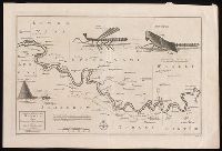
- Creator:
- Leach, John, Captain
- Published / Created:
- [approximately 1745]
- Call Number:
- BrSides 2019 87
- Image Count:
- 1
- Resource Type:
- Maps, Atlases & Globes
- Found in:
- Beinecke Rare Book and Manuscript Library > A map of the River Gambra from Eropina to Barrakunda / by Captn. John Leach in 1732 ; Thos. Kitchin sculpt.
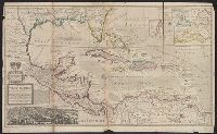
- Published / Created:
- [1720?]
- Call Number:
- 85 1720
- Container / Volume:
- BRBL_00636
- Image Count:
- 1
- Resource Type:
- Maps, Atlases & Globes
- Found in:
- Beinecke Rare Book and Manuscript Library > A map of the West Indies or the Islands of America ... explaining what belongs to Spain, England, France, Holland & c. also ye trade winds ...
- Published / Created:
- [1770]
- Call Number:
- 11 1770
- Container / Volume:
- BRBL_00005
- Image Count:
- 1
- Resource Type:
- Maps, Atlases & Globes
- Found in:
- Beinecke Rare Book and Manuscript Library > A map of the World Corrected from the observations communicated to the Royal Societys of London and Paris by John Senex. H. Hulsbergh Sc.
- Creator:
- Kitchin, Thomas, d. 1784
- Published / Created:
- 1778
- Call Number:
- 76 1778
- Container / Volume:
- BRBL_00690
- Image Count:
- 2
- Resource Type:
- Maps, Atlases & Globes
- Found in:
- Beinecke Rare Book and Manuscript Library > A map of the colony of Rhode Island [cartographic material] : with the adjacent parts of Connecticut, Massachusetts Bay, & c / by Thos. Kitchin Senr., Hydrographer to His Majesty.
- Creator:
- L'Isle, Guillaume de, 1675-1726
- Published / Created:
- [1720?]
- Call Number:
- 3826 1710
- Container / Volume:
- BRBL_00684
- Image Count:
- 1
- Resource Type:
- Maps, Atlases & Globes
- Found in:
- Beinecke Rare Book and Manuscript Library > A map of the county of Flanders / [cartographic material] / by William de l'Isle ...
- Creator:
- Kitchin, Thomas, 1718-1784
- Published / Created:
- 1756
- Call Number:
- 755 1765A
- Container / Volume:
- BRBL_00690
- Image Count:
- 1
- Resource Type:
- Maps, Atlases & Globes
- Found in:
- Beinecke Rare Book and Manuscript Library > A map of the eastern part of the Province of New York : with part of New Jersey &c. / drawn from the best authorities by T. Kitchin geogr.
- Creator:
- Rocque, John, -1762.
- Published / Created:
- [between 1762 and 1773]
- Call Number:
- 327 1785
- Image Count:
- 2
- Resource Type:
- Maps, Atlases & Globes
- Found in:
- Beinecke Rare Book and Manuscript Library > A map of the kingdom of Ireland : divided into provinces, counties and baronies, shewing the archbishopricks, bishopricks, cities, boroughs, market towns, villages, barracks, mountains, lakes, bogs, rivers, bridges, ferries, passes : also, the great, the branch and the by post roads, together with the inland navigation, &c. / by John Rocque ...
- Creator:
- Jefferys, Thomas, -1771.
- Published / Created:
- November 29th 1755.
- Call Number:
- 76 1755A
- Container / Volume:
- BRBL_00443
- Image Count:
- 2
- Resource Type:
- Maps, Atlases & Globes
- Found in:
- Beinecke Rare Book and Manuscript Library > A map of the most inhabited part of New England : containing the provinces of Massachusetts Bay and New Hampshire, with the colonies of Konektikut and Rhode Island, divided into counties and townships: The whole composed from actual surveys and its situat