Search
You Searched For
Search Results
- Creator:
- Royal Geographical Society (Great Britain)
- Published / Created:
- 1909
- Call Number:
- 19 1909A
- Container / Volume:
- BRBL_00013
- Image Count:
- 1
- Resource Type:
- Maps, Atlases & Globes
- Found in:
- Beinecke Rare Book and Manuscript Library > British Antarctic Expedition, 1907 [cartographic material] : general map showing the explorations and surveys of the Expedition, 1907-09.
- Creator:
- Royal Geographical Society (Great Britain)
- Published / Created:
- 1911
- Call Number:
- 9065 1911
- Container / Volume:
- BRBL_00667
- Image Count:
- 1
- Resource Type:
- Maps, Atlases & Globes
- Found in:
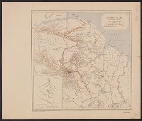
- Beinecke Rare Book and Manuscript Library > British Guiana to illustrate a paper by J.A.J. De Villiers.
- Creator:
- Royal Geographical Society (Great Britain)
- Published / Created:
- 1907
- Call Number:
- 65 1907
- Container / Volume:
- BRBL_00341
- Image Count:
- 1
- Resource Type:
- Maps, Atlases & Globes
- Found in:
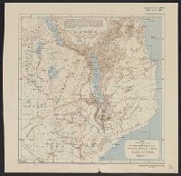
- Beinecke Rare Book and Manuscript Library > Central Africa. Route of the Alexander-Gosling expedition from the River Niger to the Red Sea, 1904-7 [cartographic material].
- Creator:
- Royal Geographical Society (Great Britain)
- Published / Created:
- [191-]
- Call Number:
- 53ed 1917
- Container / Volume:
- BRBL_00286
- Image Count:
- 1
- Resource Type:
- Maps, Atlases & Globes
- Found in:
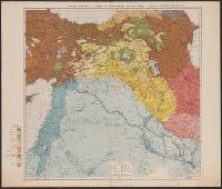
- Beinecke Rare Book and Manuscript Library > Map of eastern Turkey in Asia, Syria and western Persia (ethnographical).
- Creator:
- Royal Geographical Society (Great Britain)
- Published / Created:
- 1912
- Call Number:
- 64 1912
- Container / Volume:
- BRBL_00338
- Image Count:
- 1
- Resource Type:
- Maps, Atlases & Globes
- Found in:
- Beinecke Rare Book and Manuscript Library > Map to illustrate the paper by Sir Alfred Sharpe, K.C.M.G., C.B., LL.D. on British Central Africa.
- Creator:
- Royal Geographical Society (Great Britain)
- Published / Created:
- 1911
- Call Number:
- 19 1911
- Container / Volume:
- BRBL_00013
- Image Count:
- 1
- Resource Type:
- Maps, Atlases & Globes
- Found in:
- Beinecke Rare Book and Manuscript Library > Maps to illustrate the paper by J.B. Charcot on the French Antarctic Expedition, 1908-1910 [cartographic material].
- Creator:
- Royal Geographical Society (Great Britain)
- Published / Created:
- 1909
- Call Number:
- 183 1908
- Container / Volume:
- BRBL_00013
- Image Count:
- 1
- Resource Type:
- Maps, Atlases & Globes
- Found in:
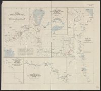
- Beinecke Rare Book and Manuscript Library > North East Greenland, sketch map : showing the surveys of the Danish expedition, 1906-8.
- Creator:
- Royal Geographical Society (Great Britain)
- Published / Created:
- 1909
- Call Number:
- 654 1909
- Container / Volume:
- BRBL_00344
- Image Count:
- 1
- Resource Type:
- Maps, Atlases & Globes
- Found in:
- Beinecke Rare Book and Manuscript Library > Sketch map to illustrate the journey of Hanns Vischer across the Sahara from Tripoli to Lake Chad / Geographical Journal, the Royal Geographical Society.
- Creator:
- Royal Geographical Society (Great Britain)
- Published / Created:
- 1913
- Call Number:
- 6551 1913
- Container / Volume:
- BRBL_00346
- Image Count:
- 1
- Resource Type:
- Maps, Atlases & Globes
- Found in:
- Beinecke Rare Book and Manuscript Library > Southern Nigeria : to illustrate the paper by A.E. Kitson.
- Creator:
- Royal Geographical Society (Great Britain)
- Published / Created:
- 1894
- Call Number:
- 592 1894
- Container / Volume:
- BRBL_00319
- Image Count:
- 2
- Resource Type:
- Maps, Atlases & Globes
- Found in:
- Beinecke Rare Book and Manuscript Library > The Karakoram Himalayas / surveyed in 1892 by W. Martin Conway, & reduced from his drawings ; published by the Royal Geographical Society.