Spain. Comision hidrografica United States. Adjutant-General's Office. Military Information Division
Published / Created:
1900
Call Number:
28 1900
Container / Volume:
BRBL_00023E
Image Count:
1
Resource Type:
Maps, Atlases & Globes
Description:
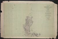
[Sheet] 1, no. 59 only., In Spanish; overprinting in English., Overprinted on 1888 hydrographic chart published by the Direccion de hidrografia, Madrid., and Overprinting shows 1900 U.S. military telegraph and cable lines, Eastern Cable Company's lines, and Mili
Publisher:
Issued by the War Dept., Adjutant General's Office, Military Information Division,
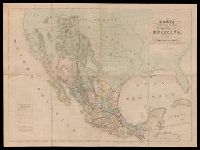
"Engraved by B.R. Davies, 16 George Str. Euston Squ., London. From the original survey made by order of the Mexican Government.", "Esta edicion se hace provicionalmente mientras se concluye la Carta en Escala mayor. Pedro Garcia Conde.", Prime meridian: Mexico City., and Relief shown by hachures.
Publisher:
s.n.,
Subject (Geographic):
Mexico--Maps and West (U.S.)--Maps
Subject (Name):
Davies, Benjamin Rees and García Conde, Pedro, 1806-1851
"Constructed, projected and drawn by Fred D. Stuart, hydrographer, late of the U.S. Ex. Ex.", "Entered according to act of Congress in the 1851 by Cadwalader Ringgold ....", "Sheet no. 1.", Inset view: Entrance to San Francisco., and Place names in English and Spanish.
Publisher:
C.B. Graham, Lithr.,
Subject (Geographic):
San Francisco Bay (Calif.)--Maps and San Francisco Bay Area (Calif.)--Maps
Subject (Name):
Blunt, Simon Fraser, d. 1854, Graham, C. B. (Curtis B.), and Stuart, Fred D
"Entered according to act of Congress in the year 1851 by Cadwalader Ringgold ....", "Projected, constructed & drawn by Fred D. Stuart, hydrographer, late of the U.S. Ex. Ex. ; assisted by A.H. Campbell, civil engineer.", "Sheet no. 2.", and Inset views: Mark for invincible buoy, north extreme of Marin Is. on with clump of trees north of San Rafael -- Mark for invincible buoy, Point Smith, east end of Angel I. on with Signal Hill.
Publisher:
C.B. Graham, Lithr.,
Subject (Geographic):
San Francisco Bay (Calif.)--Maps, San Francisco Bay Area (Calif.)--Maps, and San Pablo Bay (Calif.)--Maps
Subject (Name):
Blunt, Simon F, Campbell, Albert H. (Albert Henry), 1826-1899, Graham, C. B. (Curtis B.), and Stuart, Fred D
Subject (Topic):
Nautical charts--California--San Francisco Bay and Nautical charts--California--San Pablo Bay
Insets: Vista de ma Mina de Corbou descubierta per F. Ferrer en Choutáles -- Plan y vista de las Minas Luigalpa en Choudales -- Plan de hatogrande en Choudales., Prime meridians: Washington - Greenwich., and Relief shown by hachures; depths shown by isolines.
In bottom margin: Andrew B. Graham, photo-litho, Washington, D.C., In English and Spanish., and Prime meridians: Greenwich and Paris.
Publisher:
Andrew B. Graham?],
Subject (Name):
Andrew B. Graham Co, International American Conference (2nd : 1901-1902 : Mexico), Pan-American Railway--Maps, and Permanent Pan-American Railway Committee
Subject (Topic):
Railroads--Latin America--Maps and Railroads--North America--Maps
Inset map of England and Wales on same scale., Issued, Map shows major methods of communication and transportation., Map text and explanation in Spanish and English., and On verso: 37p. description of the country with statistical information by Eduardo Higginson.
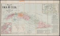
Includes text., Insets: [Spanish territory in Western Hemisphere]--City of Habana--Province of Havana., Relief shown by hachures., and Shows railroads, provinces, roads, light houses, and territory held by Spain.
Publisher:
J.L. Smith,
Subject (Geographic):
Cuba., Cuba--Maps., and Spain--Colonies--Cuba--Maps.