Search
You Searched For
Search Results
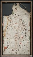
- Creator:
- Roselli, Petrus, active 1446-1468, cartographer
- Published / Created:
- [approximately 1450-1475]
- Call Number:
- Art Storage 49cea 1425
- Image Count:
- 2
- Resource Type:
- cartographic image
- Found in:
- Beinecke Rare Book and Manuscript Library > Portolan chart of the Mediterranean Sea and the Black Sea
- Creator:
- Freducci, Conte di Ottomano, active 1497-1539, cartographer
- Published / Created:
- [1536?]
- Call Number:
- Covers 49 +1536
- Image Count:
- 6
- Resource Type:
- cartographic image
- Found in:
- Beinecke Rare Book and Manuscript Library > Composite atlas of portolan charts produced by Conte di Ottomano Freducci
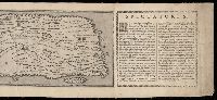
- Published / Created:
- MDXCVIII [1598]
- Call Number:
- 2016 +333
- Image Count:
- 13
- Resource Type:
- cartographic image
- Found in:
- Beinecke Rare Book and Manuscript Library > Tabula itineraria ex illustri Peutingerorum Bibliotheca quae Augustae Vindel est beneficio Marci Velseri Septemuiri Augustani in lucem edita. Nobilissimo viro Marco Velsero r.p. Augustanae Septemuiro Ioannes Moretus typographus Antverp s.p.d. ... [cartographic material].
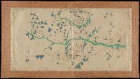
- Creator:
- Volčić, Vicko Dimitrije, 1563-1607, cartographer
- Published / Created:
- [1601]
- Call Number:
- Manuscript 49cea 1601
- Image Count:
- 2
- Resource Type:
- cartographic image
- Found in:
- Beinecke Rare Book and Manuscript Library > [Portolan chart of the Mediterranean Sea].
- Published / Created:
- [not after 1624]
- Call Number:
- Lanman 5626 1624
- Image Count:
- 1
- Resource Type:
- cartographic image
- Found in:
- Beinecke Rare Book and Manuscript Library > [Jiangxi Yuanzhou Fu tu]., [江西袁州府圖].
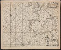
- Creator:
- Blaeu, Joan, 1596-1673, cartographer
- Published / Created:
- [1655]
- Call Number:
- 21 1670B
- Image Count:
- 1
- Resource Type:
- cartographic image
- Found in:
- Beinecke Rare Book and Manuscript Library > Paskaerte van de Westersche Schipvaert van Nederland af tot de Canarise en Vlaemse Eylanden
- Creator:
- Blaeu, Joan, 1596-1673, cartographer
- Published / Created:
- [1655]
- Call Number:
- 21 1670A
- Image Count:
- 1
- Resource Type:
- cartographic image
- Found in:
- Beinecke Rare Book and Manuscript Library > Paskaerte van de Oosterse en Noordse Schipvaert van Nederlandt tot Nova Zembla
- Creator:
- Lotter, Tobias Conrad, 1717-1777, cartographer
- Published / Created:
- [between 1741 and 1760]
- Call Number:
- 71 1737A
- Image Count:
- 1
- Resource Type:
- cartographic image
- Found in:
- Beinecke Rare Book and Manuscript Library > Mappa geographica regionem Mexicanam et Floridam terrasque adjacentes, ut et anteriores Americae insulas, cursus itidem et reditus navigantium versus flumen Missisipi et alias colonias ob oculos ponens / [cartographic material]
- Creator:
- Lotter, Tobias Conrad, 1717-1777, cartographer
- Published / Created:
- [between 1741 and 1760]
- Call Number:
- 85 1740D
- Image Count:
- 1
- Resource Type:
- cartographic image
- Found in:
- Beinecke Rare Book and Manuscript Library > Mappa geographica regionem Mexicanam et Floridam terrasque adjacentes, ut et anteriores Americae insulas, cursus itidem et reditus navigantium versus flumen Missisipi et alias colonias ob oculos ponens / [cartographic material]
- Creator:
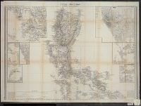
- Ainslie, John (Surveyor)
- Published / Created:
- [1800]
- Call Number:
- Folio 15 800Ai
- Image Count:
- 1
- Resource Type:
- cartographic image
- Found in:
- Lewis Walpole Library > Scotland : drawn and engrav'd from a series of angles and astronomical observations
- Published / Created:
- [between 1800 and 1899?]
- Call Number:
- GEN MSS FILE 601 (Oversize)
- Image Count:
- 2
- Resource Type:
- cartographic image
- Found in:
- Beinecke Rare Book and Manuscript Library > Portolan chart of western Europe and the Mediterranean Sea
- Published / Created:
- [not after 1841]
- Call Number:
- Covers 56cea +1840
- Image Count:
- 136
- Resource Type:
- cartographic image
- Found in:
- Beinecke Rare Book and Manuscript Library > [Zhongguo gu hang hai tu]., [中國古航海圖].
- Creator:
- Koyano, Ishun, creator
- Published / Created:
- Bunka 6, 6th month :
- Call Number:
- 2018 +512
- Image Count:
- 154
- Resource Type:
- cartographic image
- Found in:
- Beinecke Rare Book and Manuscript Library > Visualized map of all the countries
- Creator:
- Arrowsmith, Aaron, 1750-1823, cartographer
- Published / Created:
- [1820]
- Call Number:
- 71 1820B
- Image Count:
- 1
- Resource Type:
- cartographic image
- Found in:
- Beinecke Rare Book and Manuscript Library > A map exhibiting all the new discoveries in the interior parts of North America : inscribed by permission to the honorable governor and company of adventurers of England trading into Hudsons Bay, in testimony of their liberal communications to their most obedient and very humble servant, A. Arrowsmith, Hydrographer to His Majesty
- Creator:
- Dong, Fangli, active 19th century, cartographer
董方立, active 19th century, cartographer
- Published / Created:
- Daoguang 12 [1842]
- Call Number:
- Covers 56 +1842
- Image Count:
- 1
- Resource Type:
- cartographic image
- Found in:
- Beinecke Rare Book and Manuscript Library > Huang chao yi tong yu di quan tu, 皇朝壹統輿地全圖
- Creator:
- Ogilby, R. E., artist
- Published / Created:
- [approximately 1850]
- Call Number:
- WA Prints 431
- Image Count:
- 1
- Resource Type:
- cartographic image
- Found in:
- Beinecke Rare Book and Manuscript Library > Grass Valley, Nevada County, California
- Creator:
- Ogilby, R. E., artist
- Published / Created:
- [approximately 1850]
- Call Number:
- WA Prints 431
- Image Count:
- 1
- Resource Type:
- cartographic image
- Found in:
- Beinecke Rare Book and Manuscript Library > Grass Valley, Nevada County, California
- Creator:
- Hollar, Wenceslaus, 1607-1677, cartographer
- Published / Created:
- [between 1850 and 1900?]
- Call Number:
- 32 Ox1 1643
- Image Count:
- 1
- Resource Type:
- cartographic image
- Found in:
- Beinecke Rare Book and Manuscript Library > Oxforde
- Published / Created:
- 1852.
- Call Number:
- 28 1852B
- Image Count:
- 2
- Resource Type:
- cartographic image
- Found in:
- Beinecke Rare Book and Manuscript Library > Islas Filipinas [cartographic material]
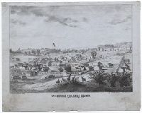
- Creator:
- Goddard, George H. (George Henry), 1817-1906, artist
- Published / Created:
- May 1853.
- Call Number:
- WA Prints 432
- Image Count:
- 1
- Resource Type:
- cartographic image
- Found in:
- Beinecke Rare Book and Manuscript Library > Springfield, Tuolumne County
- Creator:
- Goddard, George H. (George Henry), 1817-1906, artist
- Published / Created:
- May 1853.
- Call Number:
- WA Prints 432
- Image Count:
- 1
- Resource Type:
- cartographic image
- Found in:
- Beinecke Rare Book and Manuscript Library > Springfield, Tuolumne County
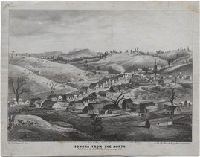
- Creator:
- Goddard, George H. (George Henry), 1817-1906, artist
- Published / Created:
- May 1853.
- Call Number:
- WA Prints 391
- Image Count:
- 1
- Resource Type:
- cartographic image
- Found in:
- Beinecke Rare Book and Manuscript Library > Sonora from the north
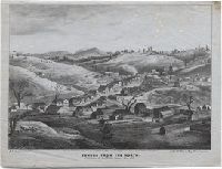
- Creator:
- Goddard, George H. (George Henry), 1817-1906, artist
- Published / Created:
- May 1853.
- Call Number:
- WA Prints 391
- Image Count:
- 1
- Resource Type:
- cartographic image
- Found in:
- Beinecke Rare Book and Manuscript Library > Sonora from the north
- Creator:
- Scott, F. H., Major, cartographer
- Published / Created:
- 1855.
- Call Number:
- Covers 59 1855
- Image Count:
- 4
- Resource Type:
- cartographic image
- Found in:
- Beinecke Rare Book and Manuscript Library > Map of the peninsula of India, comprising the whole of the Madras Presidency, and portions of the adjacent territories of Bengal and Bombay [cartographic material]
- Creator:
- Goddard, George H. (George Henry), 1817-1906, cartographer
- Published / Created:
- [1855?]
- Call Number:
- BrSides Zc72 855gn
- Image Count:
- 2
- Resource Type:
- cartographic image
- Found in:
- Beinecke Rare Book and Manuscript Library > Map of a survey of the Mokelumne Hill Canal and a reconnoissance of the adjoining country / [cartographic material]
- Creator:
- Lehman, Christian, creator
- Published / Created:
- [1857]
- Call Number:
- 2018 Folio 173
- Image Count:
- 93
- Resource Type:
- cartographic image
- Found in:
- Beinecke Rare Book and Manuscript Library > An explanation of the original location and general plan or draught of the lands and lots of Germantown and Creesam Townships, copied from Matthias Zimmerman's original dated June 26th A.D. 1746, and of the several districts and divisions thereof, part extracted from original and former draughts and part done and taken from actual mensuration drawn by Christian Lehman, July 28, 1776, recopied by his grandson Joseph Lehman, January 1, 1824, from which recopy this copy was taken, August 1857, for Peter E. Keyser
- Creator:
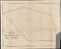
- Searle, S.W., cartographer
- Published / Created:
- 1859.
- Call Number:
- 766 N46 1859
- Image Count:
- 1
- Resource Type:
- cartographic image
- Found in:
- Beinecke Rare Book and Manuscript Library > Map of the city of New Haven, Connecticut
- Creator:
- Searl, S. W., cartographer
- Published / Created:
- [1863]
- Call Number:
- BrSides Folio 2014 10
- Image Count:
- 2
- Resource Type:
- cartographic image
- Found in:
- Beinecke Rare Book and Manuscript Library > Plan of the New Haven City burial ground
- Creator:
- Mitchell, Donald Grant, 1822-1908, cartographer
- Published / Created:
- Decr. 1863.
- Call Number:
- Roll Map 78
- Image Count:
- 2
- Resource Type:
- cartographic image
- Found in:
- Beinecke Rare Book and Manuscript Library > Map of a portion of Westville & New Haven
- Creator:
- Mitchell, Donald Grant, 1822-1908, cartographer
- Published / Created:
- [1870?]
- Call Number:
- Manuscript 766 N46 1870F
- Image Count:
- 1
- Resource Type:
- cartographic image
- Found in:
- Beinecke Rare Book and Manuscript Library > Map of Horse Railroad, Westville, & part of New Haven : enlarged four-fold from the county survey
- Creator:
- J.L. Smith Co., cartographer, publisher
- Published / Created:
- 1874.
- Call Number:
- 754gme 1874
- Image Count:
- 1
- Resource Type:
- cartographic image
- Found in:
- Beinecke Rare Book and Manuscript Library > Map of the Baltimore, Chesapeake & Delaware Bay Railroad
- Creator:
- United States. War Department. Corps of Engineers, cartographer, publisher
- Published / Created:
- [1875?]
- Call Number:
- 831 1875
- Image Count:
- 1
- Resource Type:
- cartographic image
- Found in:
- Beinecke Rare Book and Manuscript Library > Montana Territory
- Creator:
- Mitchell, Donald Grant, 1822-1908, cartographer
- Published / Created:
- [not before 1876]
- Call Number:
- Manuscript 766 N46 1870E
- Image Count:
- 1
- Resource Type:
- cartographic image
- Found in:
- Beinecke Rare Book and Manuscript Library > Manuscript map of New Haven Green to Edgewood by Donald G. Mitchell
- Creator:
- Morse, D. D., artist
- Published / Created:
- ©1880.
- Call Number:
- BrSides Zc39 880mo
- Image Count:
- 1
- Resource Type:
- cartographic image
- Found in:
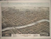
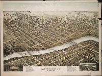
- Beinecke Rare Book and Manuscript Library > Bird's eye view of Lawrence, Kansas, 1880 [cartographic material]
- Creator:
- Morse, D. D., artist
- Published / Created:
- ©1880.
- Call Number:
- BrSides Zc39 880mo
- Image Count:
- 1
- Resource Type:
- cartographic image
- Found in:
- Beinecke Rare Book and Manuscript Library > Bird's eye view of Lawrence, Kansas, 1880 [cartographic material]
- Creator:
- United States. War Department. Corps of Engineers, cartographer, publisher
- Published / Created:
- [1881]
- Call Number:
- 831 1881A
- Image Count:
- 2
- Resource Type:
- cartographic image
- Found in:
- Beinecke Rare Book and Manuscript Library > Montana Territory
- Creator:
- Walker, John, 1786-1873, cartographer
- Published / Created:
- 1882.
- Call Number:
- Covers 59 +1882
- Image Count:
- 2
- Resource Type:
- cartographic image
- Found in:
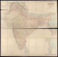
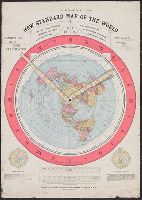
- Beinecke Rare Book and Manuscript Library > Map of India : shewing the British territories, subdivided into collectorates and including British Burmah, with the position and boundary of each native state
- Published / Created:
- 1892.
- Call Number:
- 11 1892
- Image Count:
- 2
- Resource Type:
- cartographic image
- Found in:
- Beinecke Rare Book and Manuscript Library > Gleason's new standard map of the world : on the projection of J.S. Christopher, Modern College, Blackheath, England ; scientifically and practically correct ; as "it is."
- Creator:
- United States. General Land Office
- Published / Created:
- [1908]
- Call Number:
- BrSides Zc35 908un
- Image Count:
- 2
- Resource Type:
- cartographic image
- Found in:
- Beinecke Rare Book and Manuscript Library > Sectionized map of Cheyenne River and Standing Rock Indian Reservation opened by act of May 29, 1908 [cartographic material]
- Published / Created:
- [between 1910 and 1920]
- Call Number:
- BrSides Zc72 910cu
- Image Count:
- 2
- Resource Type:
- cartographic image
- Found in:
- Beinecke Rare Book and Manuscript Library > Cragmont
- Creator:
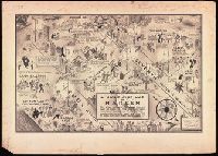
- Campbell, E. Simms (Elmer Simms), 1906-1971, creator
- Call Number:
- BrSides Double Folio 2016 34
- Image Count:
- 1
- Resource Type:
- cartographic image
- Found in:
- Beinecke Rare Book and Manuscript Library > A night-club map of Harlem : the stars indicate the places that are open all night, the only important omission is the location of the various speakeasies but since there are about 500 of them you won't have much trouble
- Published / Created:
- [approximately 1960]
- Call Number:
- Art Storage 1019
- Image Count:
- 2
- Resource Type:
- cartographic image
- Found in:
- Beinecke Rare Book and Manuscript Library > [Portolan chart of the Mediterranean Sea, the North Atlantic Ocean, the Black Sea, and the northwestern African coast].
- Creator:
- Sanborn Map Company, issuing body
- Published / Created:
- 1973.
- Call Number:
- Folio G1244 N48 S26 1973 (LC)
- Image Count:
- 445
- Resource Type:
- cartographic image
- Found in:
- Beinecke Rare Book and Manuscript Library > Sanborn maps of New Haven