Also shows Amerindian reservations: Cayuga Reservation -- Onondago Reservation -- Oneida Reservation., Imperfect: mutilated. Backed with paper., Includes note describing the numbering of military-township lots., and Shows property tract boundaries, town (militar
Publisher:
[publisher not identified],
Subject (Geographic):
New York (State)--Administrative and political divisions--Maps--Early works to 1800, New York (State)--Upstate New York, and Upstate New York (N.Y.)--Administrative and political divisions--Maps--Early works to 1800
Subject (Name):
Tiebout, Cornelius, 1777-1832
Subject (Topic):
Administrative and political divisions, Indian reservations--New York (State)--Maps--Early works to 1800., Landowners--New York (State)--Maps--Early works to 1800., and Landowners--New York (State)--Upstate New York--Maps--Ear
Covers Nova Scotia, New Brunswick, Prince Edward Island, and part of Quebec., Includes text in lower margin., Manuscript note at bottom below price, "Plain or Coloud.", Prime meridian: London., and Relief shown pictorially.
Publisher:
Publish'd according to Act of Parlian't Apr'l 21st, 1749, by Ino. Gibson engraver in Bartlet Street Clerkenwell & sold by the printsellers in London & Westminster,
Subject (Geographic):
Acadia--Maps--Early works to 1800., Maritime Provinces--Maps--Early works to 1800., North America--Acadia, and Québec (Province)--Maps--Early works to 1800.
Navigantium atque itinerantium bibliotheca ; Or, A complete collection of voyages and travels
Image Count:
1
Resource Type:
Maps, Atlases & Globes
Alternative Title:
New and accurate map of China
Description:
From: Navigantium atque itinerantium bibliotheca, or, A complete collection of voyages and travels / originally published in two volumes in folio, by John Harris. London : Printed for T. Osborne [and others], 1764., In upper right margin: Vol. II. Page 961., Map of China showing provincial divisions. Relief shown pictorially., Prime meridian: London., and Watermark.
Publisher:
[Printed for T. Osborne],
Subject (Geographic):
China--Maps--Early works to 1800.
Subject (Name):
Harris, John, 1667?-1719. Navigantium atque itinerantium bibliotheca.
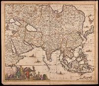
Appears in various editions of Wit's Atlas., Hand colored in outline., Imperfect: chipped and torn along edges, with no loss of text. Backed with paper., Map of Asia from Saudi Arabia, Russia, India, China, Japan to Southeast Asia., Number "4" in upper right corner., and Relief shown pictorially.
Shows topographic features, locations of forts and missions and Native American inhabitation.
Description:
In French., Relief shown pictorially., Removed from Jean-Francois de La Harpe's Abrege de l'historie générale des voyages par La Harpe with page numbers Tom XIV., and Watermark.
Publisher:
[Jean-Francois de La Harpe],
Subject (Geographic):
Florida--Maps--Early works to 1800., Louisiana--Maps--Early works to 1800., and North America--Maps--Early works to 1800
Subject (Name):
La Harpe, Jean-François de, 1739-1803. Abrege de l'historie générale des voyages.
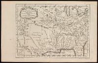
"Tom. XIV. in 4°, no. 9. Tome 14. in 8°, page 97." in lower margin., Appears in Jean François de La Harpe's Abrégé de l'histoire générale des voyages. 1780., Covers the area from Penobscot Bay to Chesapeake Bay and west to Lake Erie., Prime meridian: Paris., Relief shown pictorially., Shows provices, towns, forts, rivers, Indian tribal territory, and relief., and Watermark.
Publisher:
[publisher not identified],
Subject (Geographic):
Middle Atlantic States--Maps--Early works to 1800. and New England--Maps--Early works to 1800.
Subject (Name):
La Harpe, Jean-François de, 1739-1803. Abrégé de l'histoire générale des voyages.
North-American pilot for New England, New York, Pensilvania, Maryland, and Virginia.
Description:
A Scale of 5 "English Miles" is given below the title at upper left., Below the scale: The Light-House of Sandy Hook is 40d. 27m. North Latitude., Coordinates not present on map and are approximated., Depths shown by soundings. Relief shown by hachures., First state., Includes note., Issued separately and in the first edition of Sayer & Bennett's North American Pilot for New England, New York, Pensilvania, Maryland, and Virginia. 1777., Sailing chart of the area around New York Harbor and Long Island; centered on Staten Island, York's Bay and Constable Point, extending north to Hells Gate, New York Island, Netwon Inlet, Bushwick Inlet, Wallabout Bay, Crown Point, the Battery and Ship Yards and south to the Shrewsbury River. The map extends East to include Amboy and the Raritan River, noting (Samuel?) Holland's House and east to Jamaica Bay and Plumb Island., and Watermarks.
Publisher:
Printed for Robt. Sayer & John Bennett, sea chart & map-sellers, No. 53, in Fleet Street. Published as the Act directs,
Subject (Geographic):
Atlantic Ocean--Lower Bay, Atlantic Ocean--Upper Bay, New Jersey--Sandy Hook, New York Harbor (N.Y. and N.J.) Maps--Early works to 1800., New York Region--Maps--Early works to 1800., and Sandy Hook (N.J.)
Subject (Name):
Robert Sayer and John Bennett (Firm), printmaker, printseller
Subject (Topic):
Nautical charts, Nautical charts--Hudson River Estuary (N.Y. and N.J.)--Early works to 1800., Nautical charts--Lower Bay (N.Y. and N.J.)--Early works to 1800., and Nautical charts--Upper Bay (N.Y. and N.J.)--Early works to 180
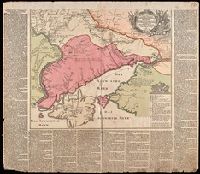
Nachricht von denen gegen die Türcken und Tartarn in diesem 1736sten Jahre vorgefallenen Kriegs-Operationen der Russisch-Kayserlichen Armée.
Description:
Imperfect: chipped along edges, with some loss of text. Reinforced with paper at top. Manuscript number 76 in upper right corner. Manuscript waste pasted to verso. From the Karpinski-von Wieser Map Collection., Includes index., Map flanked by text: "Nachricht von denen gegen die Türcken und Tartarn in diesem 1736sten Jahre vorgefallenen Kriegs-Operationen der Russisch-Kayserlichen Armée.", and Relief shown pictorially.
Publisher:
Zu haben bey Matthaeus Seutter
Subject (Geographic):
Russia--History, Military--18th century--Maps--Early works to 1800., Ukraine, Ukraine--History, Military--18th century--Maps--Early works to 1800., and Ukraine--Maps--Early works to 1800.
Subject (Name):
Imperatorskai︠a︡ akademīi︠a︡ nauk (Russia) and Russo-Turkish War (1736-1739)
Subject (Topic):
Military campaigns and Russo-Turkish War, 1736-1739--Campaigns--Ukraine--Maps--Early works to 1800.
Course of the river Mississippi from the Balise to Fort Chartres
Description:
From Thomas Jeffery's The American atlas. 1775. Also published in Faden's North America Atlas, 1777., Imperfect: torn along fold. Title in manuscript on verso., Map of the Mississippi River Valley from the Gulf of Mexico to Fort Chartres, Illinois. Covers the Mississippi Valley from the Delta of the Mississippi where it joins the Gulf of Mexico to Fort Chartres., Prime meridian: New Orleans., Relief shown pictorially and by hachures. Depths shown by soundings., Scale of "Sea Leagues, 20 to a Degree"; and "British Miles, 69 1/2 to a Degree" below the imprint., Second issue. The first issue appeared in 1772. This 1775 issue has many changes in the area around New Orleans including the addition of forts St. Leon and St. Mary. Shows Baton Rouge and Lake Pontchartrain., The first official English survey of the Lower Mississippi, and one of the most historically significant American maps, delineating the British gains from France in the French and Indian War and later establishing the future western boundary of the new United States., The map includes detail of the lands to the immediate east of the Mississippi including numerous tributary rivers: the Pearl River, the Yasous River, the Chickasaw River, and the Ohio River. The locations of tribal lands and villages are noted, as well as alliances, roads to reach the villages, and the number of soldiers for several villages. Some tribes delineated in the map include the Arkansas, Chocktaw, Chicasaw, Yazoo, Wiapes, and Caskaskias., and Watermark.
Publisher:
Printed for Robt. Sayer, No. 53 in Fleet Street. Publishd as the Act directs,
Subject (Geographic):
Mississippi River Valley--Maps--Early works to 1800. and Mississippi River--Maps--Early works to 1800.
Subject (Name):
Jefferys, Thomas, -1771. American atlas. and Sayer, Robert, 1725-1794