Chart of the West-Indies or the islands of America in the North Sea
Description:
"P. 734, v. 11.", Covers North and South American coastline from Albemarle Sound to the mouth of the Orinoco R., and Includes text and inset of "La Veracruz."
Publisher:
s.n., 1745?]
Subject (Geographic):
Caribbean Area--Maps--Early works to 1800 and West Indies--Maps--Early works to 1800
Subject (Topic):
Coasts--North America--Maps--Early works to 1800 and Coasts--South America--Maps--Early works to 1800
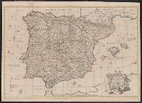
Decorative title cartouche., Dedicated to John, Lord Somers., From Senex's A new general atlas ... London: Printed for Daniel Browne ... [etc.], 1721., Hand col. Mounted on linen. Sheet measures 69 x 97 cm. Cross Collection no. 92., London meridian., Relief shown pictorially., and Shows boundaries, rivers, roads, and settlements.
Publisher:
John Senex,
Subject (Geographic):
Portugal--Early works to 1800--Maps and Spain--Early works to 1800--Maps
Subject (Name):
Senex, John, d. 1740, dedicator, Senex, John, d. 1740. New general atlas, and Somers, John Somers, Baron, 1651-1716, dedicatee
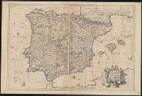
Decorative title cartouche., Dedicated to John, Lord Somers., Dissected and, From Senex's A new general atlas ... London: Printed for Daniel Browne ... [etc.], 1721., London meridian., Relief shown pictorially., and Shows boundaries, rivers, roads, and settlements.
Publisher:
John Senex,
Subject (Geographic):
Portugal--Early works to 1800--Maps and Spain--Early works to 1800--Maps
Subject (Name):
Senex, John, d. 1740, dedicator, Senex, John, d. 1740. New general atlas, and Somers, John Somers, Baron, 1651-1716, dedicatee
Lodge, John, 1756 or 7-1830, engraver Roberts, Henry, Lieut
Published / Created:
1785
Call Number:
1977 Folio 177
Image Count:
2
Resource Type:
Maps, Atlases & Globes
Alternative Title:
Political magazine.
Description:
At foot of title: Political Mag. Jany. 1785., From: The political magazine and Parliamentary, naval, military, and literary journal. London : Printed for J. Bew, 1784., Imperfect: left sheet wanting. Right sheet measures 64.2 x 48.0 cm. Ms. note at head of title: Cook's voyages. Ms. note on verso: Map of Cook's last voyage. No. 12 of 34 maps bound together., Prime meridian: Greenwich., and World map showing the Endeavour's track in the years 1768-1771, Resolution's first voyage in 1772-1775 and Resolution's second voyage in 1776-1780.
Publisher:
Printed for J. Bew],
Subject (Topic):
Voyages around the world--Maps--Early works to 1800 and World maps--Early works to 1800
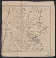
100 miles round Boston, One hundred miles around Boston, and One hundred miles round Boston
Description:
A variant of McCorkle, B.B. New England in early printed maps 1513-1800, 776.20., From the Gentleman's Magazine (June 1775), v. 45., Relief shown pictorially., Sheet measures 27.7 x 27 cm. Cross Collection no. 197., and Shows area from Cape Ann to the Connecticut River and from northern Connecticut River and from northern Connecticut and Rhode Island to Kittery and York in Maine.
Publisher:
s.n.,
Subject (Geographic):
Boston Region (Mass.)--Maps--Early works to 1800 and Massachusetts--Maps--Early works to 1800
From The Gentleman's magazine and historical chronicle (November, 1776), vol. 46., Prime meridian: London., Relief shown pictorially., Sheet measures 21.2 x 25 cm. Cross Collection no. 199., and Shows Fairfield, New Haven, and New London counties in Connecticut, towns, roads, rivers, and place names in Connecticut, Rhode Island and part of Long Island. Includes copper mine near Simsbury, Conn. Also shows relief.
Publisher:
Gentleman's Magazine,
Subject (Geographic):
Connecticut--Maps--Early works to 1800, Long Island Sound (N.Y. and Conn.)--Maps--Early works to 1800, and Rhode Island--Maps--Early works to 1800
From The Gentleman's magazine and historical chronicle (November, 1776), vol. 46., Prime meridian: London., Relief shown pictorially., Sheet measures 22.2 x 26.3 cm. Cross Collection no. 200., and Shows Fairfield, New Haven, and New London counties in Connecticut, towns, roads, rivers, and place names in Connecticut, Rhode Island and part of Long Island. Includes copper mine near Simsbury, Conn. Also shows relief.
Publisher:
Gentleman's Magazine,
Subject (Geographic):
Connecticut--Maps--Early works to 1800, Long Island Sound (N.Y. and Conn.)--Maps--Early works to 1800, and Rhode Island--Maps--Early works to 1800
From: A new general atlas, containing a geographical and historical account of all the empires, kingdoms, and other dominions of the world, 1721., Includes notes., and Relief shown pictorially.
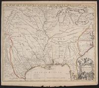
Map of the British and French Plantations in North America.
Description:
From The London Magazine (August 1755), vol. 24, p. 360., Prime meridian: London., Relief shown pictorially., Sheet measures 22.3 x 29.1 cm. Cross Collection no. 192., and Shows New England, Maritime Provinces, and eastern Quebec.
Publisher:
London Magazine,
Subject (Geographic):
Maritime Provinces--Maps--Early works to 1800, New England--Maps--Early works to 1800, and Quebec--Maps--Early works to 1800