Search
You Searched For
Search Results
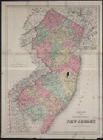
- Creator:
- G.W. & C.B. Colton & Co.
- Call Number:
- 773 1879
- Container / Volume:
- BRBL_00495
- Image Count:
- 1
- Resource Type:
- Maps, Atlases & Globes
- Found in:
- Beinecke Rare Book and Manuscript Library > Colton's larger township map of New Jersey.
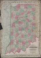
- Creator:
- Colton, J. H. (Joseph Hutchins), 1800-1893
- Published / Created:
- 1868
- Call Number:
- 805 1868
- Container / Volume:
- BRBL_00546
- Image Count:
- 1
- Resource Type:
- Maps, Atlases & Globes
- Found in:
- Beinecke Rare Book and Manuscript Library > Colton's map of the state of Indiana : compiled from the United States surveys and other authentic sources. Exhibiting sections, fractional sections, railroads, canals, etc.
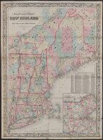
- Creator:
- Colton, G. Woolworth (George Woolworth), 1827-1901
- Published / Created:
- 1866, c1860.
- Call Number:
- 753 1866C
- Container / Volume:
- BRBL_00415
- Image Count:
- 1
- Resource Type:
- Maps, Atlases & Globes
- Found in:
- Beinecke Rare Book and Manuscript Library > G. Woolworth Colton's railroad, township & distance map of New England : with adjacent portions of New York, Canada & New Brunswick.
- Creator:
- White, Charles A. (Charles Abiathar), 1826-1910
- Published / Created:
- 1870
- Call Number:
- 847 1870
- Container / Volume:
- BRBL_00625
- Image Count:
- 4
- Resource Type:
- Maps, Atlases & Globes
- Found in:
- Beinecke Rare Book and Manuscript Library > Map of Washington Territory : west of the Cascade Mountains / compiled from the government surveys by Chas. A. White, C.E.
- Creator:
- Bowles, Samuel, 1826-1878
- Published / Created:
- [1865]
- Call Number:
- 80bh 1865
- Container / Volume:
- BRBL_00537
- Image Count:
- 1
- Resource Type:
- Maps, Atlases & Globes
- Found in:
- Beinecke Rare Book and Manuscript Library > Map of the territories and Pacific states to accompany "across the continent" / by Samuel Bowles.
- Creator:
- De Lacy, W. W. (Walter Washington), 1819-1892
- Published / Created:
- 1870
- Call Number:
- 831 1870
- Container / Volume:
- BRBL_00579
- Image Count:
- 1
- Resource Type:
- Maps, Atlases & Globes
- Found in:
- Beinecke Rare Book and Manuscript Library > Map of the territory of Montana with portions of the adjoining territories / compiled and drawn by W.W. De Lacy of the Surveyor General's Office, Helena, M.T. ; engraved, printed and published by G.W. & C.B. Colton & Co.
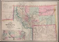
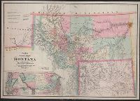
- Creator:
- De Lacy, W. W. (Walter Washington), 1819-1892
- Published / Created:
- 1871
- Call Number:
- 831 1871
- Container / Volume:
- BRBL_00579
- Image Count:
- 1
- Resource Type:
- Maps, Atlases & Globes
- Found in:
- Beinecke Rare Book and Manuscript Library > Map of the territory of Montana with portions of the adjoining territories / compiled and drawn by W.W. De Lacy of the Surveyor General's Office.
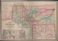
- Creator:
- De Lacy, W. W. (Walter Washington), 1819-1892
- Published / Created:
- 1878
- Call Number:
- 831 1878
- Container / Volume:
- BRBL_00579
- Image Count:
- 1
- Resource Type:
- Maps, Atlases & Globes
- Found in:
- Beinecke Rare Book and Manuscript Library > Map of the territory of Montana with portions of the adjoining territories / compiled and drawn by W.W. De Lacy, civil engineer & surveyor, Helena, M.T.
- Published / Created:
- [1866?]
- Call Number:
- 796 1866A
- Container / Volume:
- BRBL_00525
- Image Count:
- 1
- Resource Type:
- Maps, Atlases & Globes
- Found in:
- Beinecke Rare Book and Manuscript Library > Richardson's new map of the state of Texas.