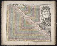
Mediterranean Sea divided into the eastern and western seas, subdivides into its principal parts or seas ... described by Sanson, corrected and amended by William Berry
Description:
Based on La Mer Mediterranee divisee enses Principales Parties, ou Mers by Nicolas Sanson., Dedicated To the most serene and most sacred majesty James II ... by William Berry., Ms. mathematical annotations in left margin., No. 23 of 69 maps bound together in composite atlas., Relief shown pictorially., and Scale [ca. 1:610 000].
Publisher:
Sold by William Berry at the signe of the Globe between Charing-Cross and White-Hall
[Atlas factice of 42 maps, produced by the Homann Erben firm]
Image Count:
2
Alternative Title:
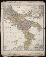
Novissima & exactissima totius regni Neapolis tabula, Novissima and exactissima totius regni Neapolis tabula, and Novissima and exactissima totivs regni Neapolis tabvla
Publisher:
Johann Baptist Homann
Subject (Geographic):
Naples (Italy : Province) --Maps --Early works to 1800 and Naples (Kingdom) --Maps --Early works to 1800
Hase, Johann Matthias, 1684-1742 Homann Erben (Firm) Lowitz, G. M. (George Moritz), 1722-1774
Published / Created:
1746
Call Number:
1975 Folio 31
Collection Title:
[Atlas factice of 42 maps, produced by the Homann Erben firm]
Image Count:
1
Alternative Title:
Mappe-monde qui represente les deux hemispheres savoir celui de l’orient et celui de l’occident, tiree des quatre cartes generales de feu M. le profess. Hasius, dressee par Mr. G.M. Lowitz et publiee par les Heritiers de Homann, avec privil. imper and Planiglobii terrestris mappa vniversalis
Publisher:
Homann Erben
Subject (Topic):
Atlases, German --Early works to 1800, Religion --Maps --Early works to 1800, and World maps --Early works to 1800
Besser, Johann von, 1654-1729 Wolffgang, Johann Georg W., 1664-1744
Published / Created:
1712
Call Number:
2010 Folio 117
Image Count:
119
Abstract:
First published in 1702, this text celebrates the coronation of Friedrich III, elector Brandenburg, as Friedrich I, king of Prussia in 1701. That edition announced the series of engravings first published in this edition, a decade later. The 24 plates, some of them pasted together to form longer panoramas, were sketched by the court painter Johann Friedrich Wentzel and engraved by Johann Georg Wolffgang.
Alternative Title:
Koeniglich-Preuessischen Croenung hochfeyeerliche Solemnitaeten, Koenigs-Krone Friderichs des Dritten, Churfuersten zu Brandenburg, Preussische Kroenungs-Geschichte, and Verlauf der Ceremonien, mit welchen der Allerdurchlauchtigste, Grossmaechtigste Fuerst und Herr, Hr. Friderich der Dritte
Publisher:
Bey Ulrich Liebpert, Koeniglich Preussischen Hoff-Buchdrucker
Subject (Name):
Frederick I, King of Prussia, 1657-1713 --Coronation --Pictorial works and Sophie Charlotte, Queen, consort of Frederick I, King of Prussia, 1668-1705
Subject (Topic):
Coronations --Germany --Berlin --Early works to 1800
Homann Erben (Firm) Homann, Johann Baptist, 1663-1724
Published / Created:
1728?
Call Number:
1973 Folio 30
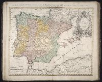
Collection Title:
[Atlas factice of 32 maps and 1 distance table, produced by the Homann Erben firm]
Image Count:
3
Alternative Title:
Regnorum Hispaniae et Portugalliae tabula generalis de l’Isliana and Reyno de Espanna dividido en dos grandes estados de Aragon y de Castilla, subdividido en muchas provincias donde se halla tambien el Reyno de Portugal
Publisher:
[Homann Erben]
Subject (Geographic):
Portugal --Maps --Early works to 1800 and Spain --Maps --Early works to 1800