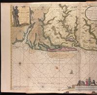
Appeared in various editions of Gerard van Keulen's Groote nieuwe Vermeerderde Zee-Atlas ofte Water-Werelt and Nieuwe groote ligtende Zee-Fakkel., Bar scales given in "Duytsche Mylen" and "Engelse en France Mylen.", Imperfect: stains at bottom, with no loss of text. Backed with paper. Ms. no. "94" in upper right-hand corner. Joined sheets measure 53.5 x 65.0 sm. or smaller. No. 84 of 87 maps bound together., Includes illustrations and decorative cartouche., Includes inset: "Afteekening van t'inkomen van de rivier van Suriname...", Oriented with south at the top., Relief shown pictorially; depths shown by soundings., and With north oriented towards the bottom.
Publisher:
By Gerard van Keulen,
Subject (Geographic):
Suriname--Maps--Early works to 1800.
Subject (Name):
Keulen, Gerard van. Groote nieuwe vermeerderde zee-atlas ofte water-waereld. and Keulen, Gerard van. Nieuwe groote lichtende zee-fakkel.
Subject (Topic):
Coasts--Suriname--Maps--Early works to 1800., Nautical charts--Suriname--Early works to 1800., and Rivers--Suriname--Maps--Early works to 1800.
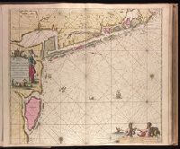
"30" in lower right corner., Appeard in Gerard van Keulen's Nieuwe groote ligtende Zee-Fakkel ... 1734; cf. Koeman, C. Atlantes Neerlandici, IV, Keu 45, map 58., Backed with paper. Ms. no. "7" in upper right-hand corner. Sheet measures 53.6 x 62.6 cm. No. 6 of 87 maps bound together., Bar scales given in "Duytsche Mylen," "Spaansche Mylen," and "Eng. en Fran. Mylen"., Relief shown pictorially., and With north oriented towards the bottom.
Publisher:
By Iohannis van Keulen ...,
Subject (Geographic):
Sør-Trøndelag (Norway)--Maps--Early works to 1800.
Subject (Name):
Keulen, Gerard van. Nieuwe groote lichtende zee-fakkel.
Subject (Topic):
Coasts--Norway--Maps--Early works to 1800. and Nautical charts--Norway--Trondheim Fjord--Early works to 1800.
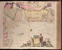
Paskaartie van de rievier de Elve streckende van Oldenbroek tot Hamburgh.
Description:
"Met priviligie voor 15 Laar"., Appeared in Gerard van Keulen's Nieuwe groote ligtende Zee-Fakkel ... 1734; cf. Koeman, C. Atlantes Neerlandici, IV, Keu 45, map 10., Bar scales given in "Duytsche Mylen," "Spaensche Mylen," and "Eng. en Fransiche Mylen"., Depths shown by soundings., Imperfect: western sheet wanting. Backed with paper. Ms. no. "44" in upper right-hand corner. No. 42 of 87 maps bound together., Inset: Paskaartie van de rievier de Elve streckende van Oldenbroek tot Hamburgh., With arrow indicating sea current., and With north oriented towards the bottom.
Publisher:
By Ioannes van Keulen, Boekverkooper en Graetboogmaaker aan de Nieubrug in de Gekroonde Loots-man,
Subject (Geographic):
Groningen (Netherlands : Province)--Maps--Early works to 1800., Lower Saxony (Germany)--Maps--Early works to 1800., and North Sea--Maps--Early works to 1800.
Subject (Name):
Keulen, Gerard van. Nieuwe groote lichtende zee-fakkel.