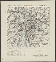
Great Britain. War Office. General Staff. Geographical Section
Published / Created:
1943
Call Number:
40 P24 1943
Container / Volume:
BRBL_00213
Image Count:
1
Resource Type:
Maps, Atlases & Globes
Alternative Title:
Geographical Section, General Staff ; no. 4380 and GSGS (Series) ; 4380.
Description:
"12/42/G.S.G.S.", "3-43.", "Authorities, Carta d'Italia 1:25,000 1935 ...", Important streets and buildings are named., In upper margin: Italy., Military grid., and Relief shown by hachures and spot heights.
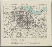
Great Britain. War Office. General Staff. Geographical Section
Published / Created:
1943
Call Number:
40 P67 1943
Container / Volume:
BRBL_00214
Image Count:
1
Resource Type:
Maps, Atlases & Globes
Alternative Title:
Geographical Section, General Staff ; no. 4380 and GSGS (Series) ; 4380.
Description:
"12/42/G.S.G.S.", "Authorities ... Carta d'Italia 1:25,000 1928 ...", "Published by War Office 1942.", "Reprint January 1943.", Important streets and buildings are named., In upper margin: Italy., Military grid., and Relief shown by hachures.
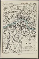
Great Britain. War Office. General Staff. Geographical Section
Published / Created:
1943
Call Number:
40 R19 1943
Container / Volume:
BRBL_00215
Image Count:
1
Resource Type:
Maps, Atlases & Globes
Alternative Title:
Geographical Section, General Staff ; no. 4380, GSGS (Series) ; 4380., and Italy
Description:
"12/42/G.S.G.S.", "3-43.", "Authorities, Carta d'Italia 1:25,000, 1935.", "Published by War Office 1942.", Important streets and buildings are named., Military grid., and Relief shown by hachures.
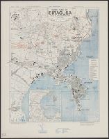
Great Britain. War Office. General Staff. Geographical Section
Published / Created:
1943
Call Number:
408 Sy76 1943
Container / Volume:
BRBL_00239
Image Count:
1
Resource Type:
Maps, Atlases & Globes
Alternative Title:
Geographical Section, General Staff ; no. 4379, GSGS (Series) ; 4379., Sicily 1:7,500, and Sicily 1:7,500, town plan of Siracusa
Description:
"Contours at 10 metres interval.", "Enlarged from the 1/25,000 Italian map dated 1927.", "Published by the War Office, 1942, 2nd edition, 1943.", "Revised from air photographs and intelligence reports up to, and Some buildings indicated; principal streets named.
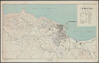
Great Britain. War Office. General Staff. Geographical Section
Published / Created:
1943
Call Number:
679 T15 1943
Container / Volume:
BRBL_00349
Image Count:
1
Resource Type:
Maps, Atlases & Globes
Alternative Title:
Geographical Section, General Staff ; no. 4241 and GSGS (Series) ; 4241.
Description:
"Contours at 5 metres interval.", "Key to numbers" lists points of interest; principal streets are named., "Published by War Office, 1941. 2nd edition, 1942. Revised by A. M. S. December 1942.", In upper margin: Morocco ..., and Military grid.
Geographical Section, General Staff ; no. 4241 and GSGS (Series) ; 4241.
Description:
"Contours at 5 metres interval.", "Key to numbers" lists points of interest; principal streets are named., Military grid., and positive photostat of 679 T15 1943?
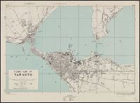
Great Britain. Army. Royal Engineers. Fd. Survey Coy., 512
Published / Created:
1943
Call Number:
40 T17 1943
Image Count:
1
Resource Type:
Maps, Atlases & Globes
Alternative Title:
Great Britain. Army. Middle East Forces. M.D.R ; 539., GSGS (Series) ; 4380., Italy 1:10,000, Italy 1:10,000, town plan of Taranto, and Provisional GSGS (Middle East) ; 4380
Description:
"8-43.", "Authorities, G.S.G.S. 4229 Italy 1:50,000 ... Italy 1:15,000 ... Inteligence information 1941.", "M.D.R. 539/8503.", Important streets and buildings are named., and Military grid.
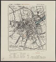
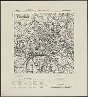
Great Britain. War Office. General Staff. Geographical Section
Published / Created:
1943
Call Number:
40 T729 1943
Image Count:
1
Resource Type:
Maps, Atlases & Globes
Alternative Title:
Geographical Section, General Staff ; no. 4380, GSGS (Series) ; 4380., Italy, and Italy, town plan of Treviso
Description:
"12/42/G.S.G.S.", "3-43.", "Authorities, Carta d'Italia 1:25,000, 1934/6. Various guide book plans.", "Published by War Office 1942.", Important streets and buildings are named., Military grid., and Relief shown by hachures and spot heights.