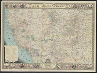
National Geographic Society (U.S.). Cartographic Section
Published / Created:
1940
Call Number:
7821 1940
Container / Volume:
BRBL_00506
Image Count:
1
Resource Type:
Maps, Atlases & Globes
Description:
Copyright: The National Geographic Society., Includes index of routes of exploration, text and ill. of notable sites and events, and state seals., Issued with the National geographic magazine, v. 77, no. 6, June 1940., and Relief shown by hachures and spot heigh
Publisher:
The Society,
Subject (Geographic):
Southwest, New--Maps
Subject (Name):
A. Hoen & Co, Brehm, J. J, Chamberlin, Wellman, Darley, James M. (James Morrison), Eastwood, H. E, Holdstock, A. E, and Riddiford, Charles E
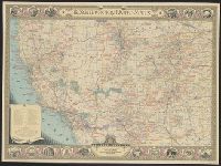
National Geographic Society (U.S.). Cartographic Section
Published / Created:
1940
Call Number:
7821 1940
Container / Volume:
BRBL_00506
Image Count:
1
Resource Type:
Maps, Atlases & Globes
Description:
Copyright: The National Geographic Society., Includes index of routes of exploration, text and ill. of notable sites and events, and state seals., Issued with the National geographic magazine, v. 77, no. 6, June 1940., Mounted on linen., and Relief shown by hachu
Publisher:
The Society,
Subject (Geographic):
Southwest, New--Maps
Subject (Name):
A. Hoen & Co, Brehm, J. J, Chamberlin, Wellman, Darley, James M. (James Morrison), Eastwood, H. E, Holdstock, A. E, and Riddiford, Charles E
Great Britain. War Office. General Staff. Geographical Section
Published / Created:
1943
Call Number:
408 Ag84 1943
Container / Volume:
BRBL_00239
Image Count:
1
Resource Type:
Maps, Atlases & Globes
Alternative Title:
Geographical Section, General Staff ; no. 4379, GSGS (Series) ; 4379., and Italy 1:5,000
Description:
"5-43.", "Enlarged, "Published by the War Office, 1942, 2nd edition, 1943.", A few important streets are named., Also shows power lines, railways, and aquaducts., Includes index to buildings., Military grid., and Relief shown by contours, hachures, and spot heights.
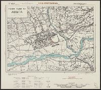
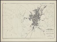
Great Britain. War Office. General Staff. Geographical Section
Published / Created:
1943
Call Number:
40 Ao75 1943
Container / Volume:
BRBL_00204
Image Count:
1
Resource Type:
Maps, Atlases & Globes
Alternative Title:
Geographical Section, General Staff ; no. 4380, GSGS (Series) ; 4380., and Italy
Description:
"12/42/G.S.G.S.", "2-43.", "Authorities, carta d'Italia 1:25,000 1930 ... various guide book plans.", "Published by War Office, 1942.", Important streets and buildings are named., Military grid., and Relief shown by form lines, hachures, and spot heights.
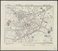
Great Britain. War Office. General Staff. Geographical Section
Published / Created:
1942,
Call Number:
40 B239 1943
Container / Volume:
BRBL_00204
Image Count:
1
Resource Type:
Maps, Atlases & Globes
Alternative Title:
Geographical Section, General Staff ; no. 4380 and GSGS (Series) ; 4380.
Description:
"Air photographs have been used in the production of this plan.", Important streets and buildings are named., In upper left margin: Italy., and Military grid.
Great Britain. War Office. General Staff. Geographical Section
Published / Created:
1943
Call Number:
40 B45 1943
Container / Volume:
BRBL_00205
Image Count:
1
Resource Type:
Maps, Atlases & Globes
Alternative Title:
Geographical Section, General Staff ; no. 4380, GSGS (Series) ; 4380., and Italy
Description:
"12/42/G.S.G.S.", "2-43.", "Authorities ... Carta d'Italia 1:25,000, 1931. Various guide book plans.", "Published by War Office 1942.", Important streets and buildings are named., and Military grid.
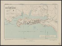
Great Britain. War Office. General Staff. Geographical Section
Published / Created:
1943
Call Number:
3897 B642 1943
Container / Volume:
BRBL_00184
Image Count:
1
Resource Type:
Maps, Atlases & Globes
Alternative Title:
Corsica 1:5,000, Geographical Section. General Staff ; no. 4381, and GSGS (Series) ; 4381.
Description:
"2/43/G.S.G.S.", "6-43.", "Air photographs have been used in the production of this plan.", Important streets are named., Military grid, "Southern Italy grid.", and Relief shown by form lines and rock drawings.
Great Britain. War Office. General Staff. Geographical Section
Published / Created:
1943
Call Number:
408 C27 1943
Container / Volume:
BRBL_00239
Image Count:
1
Resource Type:
Maps, Atlases & Globes
Alternative Title:
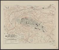
Geographical Section, General Staff ; no. 4379, GSGS (Series) ; 4379., Sicily 1:5,000, and Sicily 1:5,000, town plan of Castelvetrano
Description:
"6-43.", "Air photographs have been used in the production of this plan.", "Authorities: Italy 1:100,000, G.S.G.S., no.4164, 1942; Italy 1:50,000, G.S.G.S., no.4229, 1941; intelligence information, 1943, "Published by War Office, 1943.", and Military grid (blue).