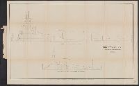
In upper right margin: No XII., Mostly shows valley of Truandó River., and Profile along the surveyed route; Profile along the proposed ship canal route.
"To accompany the Commissioner's joint report dated November 26, 1951. Upon the establishment of the boundary from Tongass Passage to Mount St. Elias in accordance with the convention of January 24, 1903, the award of the tribunal, appointed under the convention signed at London October 20, 1903 ..."
Publisher:
U.S. G.P.O.,
Subject (Geographic):
Alaska--Boundaries--Canada--Maps, Canada--Boundaries--United States--Maps, and United States--Boundaries--Canada--Maps
United States. Adjutant-General's Office. Military Information Division
Published / Created:
1905]
Call Number:
565 K63 1905A
Container / Volume:
BRBL_00299
Image Count:
1
Resource Type:
Maps, Atlases & Globes
Description:
"Andrew B. Graham Co., lithographers, Washington, D.C.", "Authority 'Karte von Ost-China' by the K. Preuss. Landes Aufnahme.", "Published as a supplement to the National Geographic magazine, Washington, D.C., for June 1905.", and Relief shown by form lines, hachures, and spot heights.
Publisher:
National Geographic Society,
Subject (Geographic):
Jilin Sheng (China)--Maps, Manchuria (China)--Maps, and Siberia, Eastern (Russia)--Maps
Subject (Name):
Andrew B. Graham Co and National Geographic Society (U.S.)
"No. VII." in upper right margin., "Surveyed by order of, "To accompany report by Rear Admiral C.H. Davis, U.S.N., ordered by resolution of the Senate of the United States of March 19, 1866.", and Includes profiles of the Bay of Panama and the Gulf of San Blas.
"No. IV." in upper right margin., "To accompany report by Rear Admiral C.H. Davis, U.S.N., ordered by resolution of the Senate of the United States of March 19, 1866.", and Includes profile of the Harbour of San Juan de Nicaragua.
In top margin: Atlas sheet no. 8., In top margin: Geology of the high plateaus of Utah by Capt. C.E. Dutton, U.S.A., Includes "note.", and Relief shown by hachures.
Publisher:
U.S. G.P.O.?,
Subject (Geographic):
Utah--Maps
Subject (Name):
Dutton, Clarence E. (Clarence Edward), 1841-1912. Topographical and geological atlas of the district of the high plateaus of Utah, Geographical and Geological Su, and Geographical and Geological Survey of the Rocky Mountain Region (U.S.)