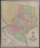
Includes text and list of town popula, Prime meridians: Greenwich and Washington., Relief shown by hachures., and Shows Indian tribes and various routes, including "Pike's Route," "Long's Route," "Gregg's Route in 1840," and "Road to Santa Fé laid out in 1825."
Publisher:
War Dept.,
Subject (Geographic):
Southwestern States--Maps and Texas--Maps
Subject (Name):
Abert, John James, 1788-1863, United States. Army. Corps of Topographical Engineers, and United States. War Dept
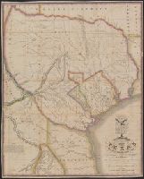
Map of Texas showing the grants in possession of the Colorado & Red River Land Comp.y
Description:
"N.B. The tracts possessed by the company are the Wilson & Exter 1st grant and the Milam grant.", Prime meridians: Greenwich and Washington., Relief shown by hachures., and Shows land grants and notes from Alexander Le Grand's survey of Wilson & Exeter's Grant.
Publisher:
P. Desobry's Lith.y,
Subject (Geographic):
Texas--Maps
Subject (Name):
Desobry, Prosper, d. 1843 and LeGrand, A. (Alexander)
"The latitude and longitude of Saltillo, Monterey, Laredo, Bexar, Nacogdoches, and the point where the boundary line leaves the Sabine are from the observations of General Teran of the Mexican Army.", From the Streeter collection., and Includes coat of arms, "note", and table of numbers of families on principal tracts of land.
Publisher:
H.S. Tanner,
Subject (Geographic):
Texas--Maps
Subject (Name):
Mier y Teran, Manuel de, Streeter, Thomas W.--(Thomas Winthrop),--1883-1965--Ownership, Tanner, Henry Schenck, 1786-1858, Warr, John, b. ca. 1798, and Warr, William W
Subject (Topic):
Land grants--Texas--Maps and Texas--Administrative and political divisions--Maps
"The latitude and longitude of Saltillo, Monterey, Laredo, Bexar, Nacogdoches and the point where the boundary line leaves the Sabine are from the observations of General Teran o, Includes coat of arms and "note"., and Prime meridians: Greenwich and Washington.
Publisher:
H. S. Tanner,
Subject (Geographic):
Texas--Maps
Subject (Name):
Mier y Teran, Manuel de, Tanner, Henry Schenck, 1786-1858, Warr, John, b. ca. 1798, and Warr, William W
Miniature sailing chart showing the route of Colombus from Oct. 11, 1492 up to approx. the 1st. of Dec. 1492. Also shown are the Great Bahama Bank, the Old Bahama Channel, part of Cuba, Jamaica, Saint Domingo, ect. and Plan by D.G. Johnson. Lettered by D.R. Harrison.
Miniature sailing chart showing the route of Colombus from Oct. 11, 1492 up to approx. the 1st. of Dec. 1492. Also shown are the Great Bahama Bank, the Old Bahama Channel, part of Cuba, Jamaica, Saint Domingo, ect. and Plan by D.G. Johnson. Lettered by D.R. Harrison.
Blue line print., In lower left corner: R.W.D., Nov. 21, 1910. R 12-1-10. S, 4/1/12-S2 4/1/12., In lower right margin: Tolland Co. Conn, 905., and Indicates lettered routes, post offices, houses, schools, churches, and collection boxes.
Publisher:
s.n.],
Subject (Geographic):
Tolland County (Conn.)--Maps
Subject (Topic):
Postal service--Connecticut--Tolland County--Maps and Rural free delivery--Connecticut--Tolland County--Maps