Inset illustration of the Reichstag of Holy Roman Empire, with title: The General Diet of the Empire, or it's Parliament.
Subject (Geographic):
Europe, Central--Maps--Early works to 1800, Germany--Maps--Early works to 1800, Hungary--Maps--Early works to 1800, Romania--Maps--Early works to 1800, and Switzerland--Maps--Early works to 1800
Subject (Name):
Holy Roman Empire.--Reichstag and Hughes, Thomas Lowe,--1925---Ownership
Delarochette, L. (Louis), 1731-1802 Kitchin, Thomas, 1718-1784. New universal atlas. 1804 Laurie & Whittle
Call Number:
36 1794B
Container / Volume:
BRBL_00119
Image Count:
2
Resource Type:
Maps, Atlases & Globes
Description:
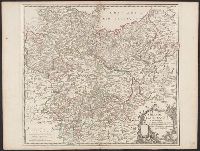
Appeared in Kitchin's New universal atlas, 6th ed., 1804., In ms. on verso: No. 27., Relief shown pictorially., and The circles of Westphalia and Lower Saxony, with the western parts of the Circle of Upper Saxony, and the northern parts of the
Subject (Geographic):
Austria--Maps--Early works to 1800, Europe, Central--Maps--Early works to 1800, and Germany--Maps--Early works to 1800
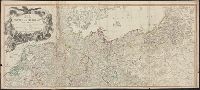
Appeared in John Thomson's New general atlas, Edinburgh (Printed by George Ramsay and Co., for John Thomson and Co., Edinburgh; Baldwin, Cradock, and Joy, London; and John Cumming, Dublin),, Printed in upper right corner: No. 31., and Relief shown by hachures.
Subject (Geographic):
Poland--Maps and Prussia (Germany)--Maps
Subject (Name):
Hughes, Thomas Lowe,--1925---Ownership, John Thomson & Co, and Thomson, John, active 19th century. New General atlas
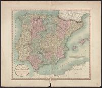
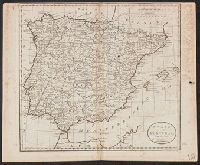
"Engraved for Careys American Edition of Guthries Geography improved.", "Meridian of London.", Includes bar scales for "British statute miles" and "Spanish miles.", On sheet 36.6 x 45 cm. Engraving statement partly trimmed., and Relief shown pictorially.
Subject (Geographic):
Iberian Peninsula--Maps--Early works to 1800, Portugal--Maps--Early works to 1800, and Spain--Maps--Early works to 1800
Subject (Name):
Carey, Mathew, 1760-1839, publisher, Guthrie, William, 1708-1770. New system of modern geography, and Hughes, Thomas Lowe,--1925---Ownership
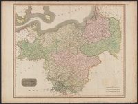
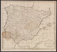
"Engraved for Careys American Edition of Guthries Geography improved.", "Meridian of London.", Includes bar scales for "British statute miles" and "Spanish miles.", On sheet 35.3 x 38.7. Backed with linen. Stain over Algarva area of, and Relief shown pictorially.
Subject (Geographic):
Iberian Peninsula--Maps--Early works to 1800, Portugal--Maps--Early works to 1800, and Spain--Maps--Early works to 1800
Subject (Name):
Carey, Mathew, 1760-1839, publisher, Guthrie, William, 1708-1770. New system of modern geography, and Hughes, Thomas Lowe,--1925---Ownership