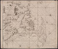
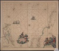
"22" in lower left and lower right corners., Appears in Keulen's De groote nieuwe vermeerderde zee-atlas ofte water-waereld., Ms., Shoal added around Accadie., and Shows Gulf of St. Lawrence from Newfoundland to the Gaspé, soundings indicated on the Grand Banks.
Publisher:
By Johannes van Keulen ...,
Subject (Geographic):
Atlantic Provinces--Maps--Early works to 1800 and Saint Lawrence, Gulf of--Maps--Early works to 1800
Subject (Name):
Keulen, Johannes van, 1654-1715. Groote nieuwe vermeerderde zee-atlas ofte water-waereld
Pascaerte vande Zvyd-Zee tussche California, en Ilhas de Ladrones
Description:
Chart of the Pacific Ocean showing the coastlines of Tasmania, Carpentaria, New Guinea, Japan, California, and Pacific Islands., Mounted on linen. Cross Collection no., and Scale is given in English, French, Dutch, and Spanish miles.
Publisher:
By Pieter Goos, op't Waater inde Vergulde Zeespiegel,
Subject (Geographic):
Pacific Ocean--Maps--Early works to 1800
Subject (Name):
Goos, Pieter, approximately 1616-1675. Zee-atlas ofte water-wereld
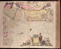
Paskaartie van de rievier de Elve streckende van Oldenbroek tot Hamburgh.
Description:
"Met priviligie voor 15 Laar"., Appeared in Gerard van Keulen's Nieuwe groote ligtende Zee-Fakkel ... 1734; cf. Koeman, C. Atlantes Neerlandici, IV, Keu 45, map 10., Bar scales given in "Duytsche Mylen," "Spaensche Mylen," and "Eng. en Fransiche Mylen"., Depths shown by soundings., Imperfect: western sheet wanting. Backed with paper. Ms. no. "44" in upper right-hand corner. No. 42 of 87 maps bound together., Inset: Paskaartie van de rievier de Elve streckende van Oldenbroek tot Hamburgh., With arrow indicating sea current., and With north oriented towards the bottom.
Publisher:
By Ioannes van Keulen, Boekverkooper en Graetboogmaaker aan de Nieubrug in de Gekroonde Loots-man,
Subject (Geographic):
Groningen (Netherlands : Province)--Maps--Early works to 1800., Lower Saxony (Germany)--Maps--Early works to 1800., and North Sea--Maps--Early works to 1800.
Subject (Name):
Keulen, Gerard van. Nieuwe groote lichtende zee-fakkel.
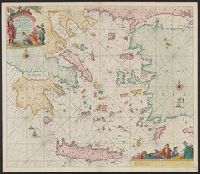
"Met priviligie voor 15 Iaar.", Appears in the author's De groote niewe vermeerderde zee-atlas ofte water-waereld., Dutch, with Latin place names., Has watermark., and Includes col. ill., decorative cartouche, and rhumb lines.
Publisher:
By Ioannes van Keulen, boeck verkooper en graad boogh maker, aen de N:Brugh inde gekroonde Loots,
Subject (Geographic):
Aegean Islands (Greece and Turkey)--Maps--Early works to 1800 and Crete (Greece)--Maps--Early works to 1800
Subject (Name):
Keulen, Johannes van, 1654-1715. Groote nieuwe vermeerderde zee-atlas ofte water-waereld
Terra Neuf, en de custen van Nieu Engeland, Nieu Nederland, Nieu Andalusia, Guiana en Venezuela
Description:
Covers the Atlantic Ocean west of the Azores and Cape Verde Islands, and the coasts of northeastern North America and northern South Amerca., Fr, In Latin and Dutch., Includes two decorative cartouches and ill., North oriented to left., and With "22" at top right.
Publisher:
Gedruckt by Fredrick de Wit in de Kalverstrae,
Subject (Geographic):
Atlantic Provinces--Maps--Early works to 1800 and North Atlantic Ocean--Maps--Early works to 1800
Subject (Name):
Wit, Frederik de. Orbis Maritimus ofte Zee Atlas
Subject (Topic):
Nautical charts--Atlantic Ocean--Early works to 1800
Terra neuf, en de custen van Nieu Vranckryck, Nieu Engeland, Nieu Nederland, Nieu Andalusia, Guiana en Venezuela
Description:
At upper right corner: Fol. 26., Covers the Atlantic Ocean west of, From Renard's Atlas de la navigation et du commerce ... Amsterdam : Chez Louis Renard, 1715., In Latin and Dutch., Includes two decorative cartouches and ill., and Oriented with north to the left.
Publisher:
Gedruckt by L. Renard,
Subject (Geographic):
North Atlantic Ocean--Maps--Early works to 1800
Subject (Name):
Renard, Louis. Atlas de la navigation et du commerce
Subject (Topic):
Nautical charts--North Atlantic Ocean--Early works to 1800