Covers Nova Scotia, New Brunswick, Prince Edward Island, and part of Quebec., Includes text in lower margin., Manuscript note at bottom below price, "Plain or Coloud.", Prime meridian: London., and Relief shown pictorially.
Publisher:
Publish'd according to Act of Parlian't Apr'l 21st, 1749, by Ino. Gibson engraver in Bartlet Street Clerkenwell & sold by the printsellers in London & Westminster,
Subject (Geographic):
Acadia--Maps--Early works to 1800., Maritime Provinces--Maps--Early works to 1800., North America--Acadia, and Québec (Province)--Maps--Early works to 1800.
Navigantium atque itinerantium bibliotheca ; Or, A complete collection of voyages and travels
Image Count:
1
Resource Type:
Maps, Atlases & Globes
Alternative Title:
New and accurate map of China
Description:
From: Navigantium atque itinerantium bibliotheca, or, A complete collection of voyages and travels / originally published in two volumes in folio, by John Harris. London : Printed for T. Osborne [and others], 1764., In upper right margin: Vol. II. Page 961., Map of China showing provincial divisions. Relief shown pictorially., Prime meridian: London., and Watermark.
Publisher:
[Printed for T. Osborne],
Subject (Geographic):
China--Maps--Early works to 1800.
Subject (Name):
Harris, John, 1667?-1719. Navigantium atque itinerantium bibliotheca.
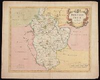
First state, produced prior to changes before 1722., From: Camden's Britannia, newly translated into English ... [London] : Printed by F. Collins, for A. Swalle ... and A. & J. Churchil ..., 1695., London meridian., Relief shown pictorially., and Shows boundaries, rivers, roads, woods, parks and settlements.
Publisher:
Sold by Abel Swale, Awnsham & Iohn Churchil,
Subject (Geographic):
Bedfordshire (England)--Maps--Early works to 1800.
Subject (Name):
Camden, William, 1551-1623. Britannia. English., Churchill, Awnsham, -1728, Churchill, John, active 1690-1714, and Swall, Abel
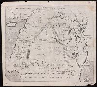
"Arabia the happie, the north part" at lower edge., From Sir Walter Raleigh's History of the world (1614)., In upper left corner: 64; in upper right corner: 65., Relief shown pictorially., Shows a portion of the Mediterranean Sea with Cyprus and Cappadocia to the northwest, the Red Sea and the Persian Sea to the south. Arabia desert and Mesopotamia near center., The map identifies the Home of Abraham at Vrocha (Chaldea), the first plantation of Chus, Babylon, Jerusalem the Garden of Eden, the City of Petra (then known to European only in legend), and the route taken by Abraham into Egypt., and Watermark.
Publisher:
[Printed by William Stansby for Walter Burre],
Subject (Geographic):
Iraq--Historical geography--Maps. and Middle East--Maps--Early works to 1800.
Subject (Name):
Raleigh, Walter, Sir, 1552?-1618. History of the world