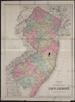
"Entered according to Act of Congress in the year 1879 by G.W. & C.B. Colton & Co. in the clerks office of the District of Court of the United States for the Eastern District of New York." and Relief shown by hachures.
Publisher:
G.W. & C.B. Colton & Co.,
Subject (Geographic):
New Jersey--Maps.
Subject (Name):
Colton, C. B, Colton, G. Woolworth (George Woolworth), 1827-1901, and G.W. & C.B. Colton & Co
Includes key to state boundary, county boundary, township & range line, section line, state capitol, county seat, villages & P.O.s, mills, roads, railroads--finished and proposed.
Publisher:
G.W. & C.B. Colton & Co.,
Subject (Geographic):
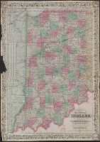
Illinois--Maps, Indiana--Maps, Michigan--Maps, and Ohio--Maps
Colton, G. Woolworth (George Woolworth), 1827-1901
Published / Created:
1866, c1860.
Call Number:
753 1866C
Container / Volume:
BRBL_00415
Image Count:
1
Resource Type:
Maps, Atlases & Globes
Alternative Title:
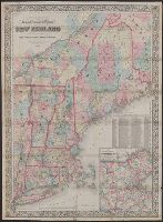
Railroad, township & distance map of New England and Railroad, township and distance map of New England
Description:
Area includes all of New England and parts of New York State, Quebec and New Brunswick., Entered according to act of Congress, in the year 1860, by G. Woolworth Colton in the clerk's office of the District Court of the Southern District of New York., and Relief
Publisher:
G.W. and C.B. Colton & Co.,
Subject (Geographic):
Massachusetts--Maps and New England--Maps
Subject (Name):
G.W. & C.B. Colton & Co
Subject (Topic):
Railroads--Massachusetts--Maps and Railroads--New England--Maps
"Entered according to act of Congress in the year 1865 by J.H. Goldthwait in the clerks office of the district court of the U.S. for the southn. distt. of New York.", Includes inset of "Plan of Central California on an enlarged scale.", and Relief shown by hachures.
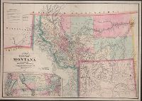
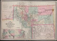
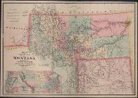
"Entered according to Act of Congress in the year 1870 by W.W. DeLacy in the Office of the Librarian of Congress at Washington.", Includes bibliographic references., Inset: Map of the northwestern portion of the United States. Scale [ca. 1:7,200,000]. Shows area from Lake Michigan to the Pacific Ocean., Prime meridians: Greenwich and Washington., Relief shown by hachures., and Shows Indian/"military reserves," areas mined for gold, silver, copper, iron and coal, and Yellowstone region.
Publisher:
Colton & Co.,
Subject (Geographic):
Montana--Maps, Wyoming--Maps, and Yellowstone National Park Region--Maps
Subject (Name):
G.W. & C.B. Colton & Co and United States. Surveyor General
Subject (Topic):
Indian reservations--Montana--Maps and Mines and mineral resources--Montana--Maps
"Entered according to act of Congress in the year 1870 by W.W. DeLacy in the office of the Librarian of Congress at Washington.", Includes inset of northwestern portion of the United States., Prime meridians: Greenwich and Washington., and Relief shown by hachures.
New map of the state of Texas, Texas, and Texas almanac for ...
Description:
"Entered according to act of Congress in the year 1866 by G.W. & C.B Colton & Co. in clerks office of the district court of the United States for the southern district of New York.", Prime meridians: Greenwich and Washington., Relief shown by hachures., and Shows counties and railroads.
Publisher:
G.W. & C.B. Colton & Co's Map Establishment,
Subject (Geographic):
Texas Panhandle (Tex.)--Maps, Texas--Administrative and political divisions--Maps, and Texas--Maps
Subject (Name):
G.W. & C.B. Colton & Co and Richardson, Willard, 1802-1875