Search
You Searched For
Search Results
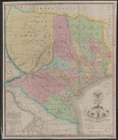
- Creator:
- Colorado and Red River Land Company, New York
- Published / Created:
- [1835?]
- Call Number:
- 796 1839A
- Container / Volume:
- BRBL_00524
- Image Count:
- 1
- Resource Type:
- Maps, Atlases & Globes
- Found in:
- Beinecke Rare Book and Manuscript Library > Map of Texas shewing the grants in possession of the Colorado & Red River Land Comp.y.
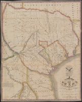
- Creator:
- Austin, Stephen F. (Stephen Fuller), 1793-1836
- Published / Created:
- 1839
- Call Number:
- 796 1839D
- Container / Volume:
- BRBL_00524
- Image Count:
- 1
- Resource Type:
- Maps, Atlases & Globes
- Found in:
- Beinecke Rare Book and Manuscript Library > Map of Texas with parts of the adjoining states / compiled by Stephen F. Austin ; engraved by John & Wm. W. Warr.
- Creator:
- Austin, Stephen F. (Stephen Fuller), 1793-1836
- Published / Created:
- [1830?]
- Call Number:
- 796 1830
- Container / Volume:
- BRBL_00524
- Image Count:
- 1
- Resource Type:
- Maps, Atlases & Globes
- Found in:
- Beinecke Rare Book and Manuscript Library > Map of Texas with parts of the adjoining states / compiled by Stephen F. Austin ; engraved by John & Wm. W. Warr.
- Published / Created:
- [1846?]
- Call Number:
- 796hc 1846
- Image Count:
- 1
- Resource Type:
- Maps, Atlases & Globes
- Found in:
- Beinecke Rare Book and Manuscript Library > Map of Texas.
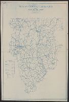
- Published / Created:
- 1925
- Call Number:
- 736 P26 1925
- Container / Volume:
- BRBL_00382
- Image Count:
- 1
- Resource Type:
- Maps, Atlases & Globes
- Found in:
- Beinecke Rare Book and Manuscript Library > Map of The Pas mineral area and adjacent territory to the north, Manitoba and Saskatchewan / ǂc compiled, drawn and printed by the Topographical Survey of Canada.
- Published / Created:
- 1823
- Call Number:
- 85 1492
- Container / Volume:
- BRBL_00636
- Image Count:
- 1
- Resource Type:
- Maps, Atlases & Globes
- Found in:
- Beinecke Rare Book and Manuscript Library > Map of The Route of Colombus on arriving among the Bahama Islands. Plan by D.G. Johnson
- Published / Created:
- 1823
- Call Number:
- 85 1492
- Container / Volume:
- BRBL_00636
- Image Count:
- 1
- Resource Type:
- Maps, Atlases & Globes
- Found in:
- Beinecke Rare Book and Manuscript Library > Map of The Route of Colombus on arriving among the Bahama Islands. Plan by D.G. Johnson
- Published / Created:
- [187-?]
- Call Number:
- 578 T578 1870A
- Container / Volume:
- BRBL_00313
- Image Count:
- 1
- Resource Type:
- Maps, Atlases & Globes
- Found in:
- Beinecke Rare Book and Manuscript Library > Map of Tokio.
- Creator:
- United States. Post Office Dept
- Published / Created:
- 1910
- Call Number:
- 766gmd T57 1912
- Container / Volume:
- BRBL_00475A
- Image Count:
- 1
- Resource Type:
- Maps, Atlases & Globes
- Found in:
- Beinecke Rare Book and Manuscript Library > Map of Tolland County, Connecticut, showing rural delivery service / Post Office Department.
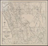
- Creator:
- Punnett Brothers
- Published / Created:
- 1905
- Call Number:
- 837gfc T61 1905
- Container / Volume:
- BRBL_00595
- Image Count:
- 1
- Resource Type:
- Maps, Atlases & Globes
- Found in:
- Beinecke Rare Book and Manuscript Library > Map of Tonopah and Goldfield mining districts and region adjacent : showing railroads, wagon roads & trails / compiled from the most authentic data by Punnett Brothers.