A textual note at upper left reads "The Course of the Ohio or Alliganey River and its Branches are laid down from Surveys and Draughts made on the Spot by M.r Gist and others in the Years 1751, 2, 3 & 4". and Cartouche designed by Francis Hayman and engraved
Publisher:
Thomas Jefferys,
Subject (Geographic):
Maryland--Maps--Early works to 1800., Middle Atlantic States--Maps--Early works to 1800., and Virginia--Maps--Early works to 1800.
Subject (Name):
Byrd, William, 1674-1744., Churton, William, 1710-1767, surveyor., Dalrymple, John, -1766, surveyor., Dandridge, William, -1743., Fitzwilliam, Richard, -1744., and Fry, Joshua, approximately 1700-1754, ca
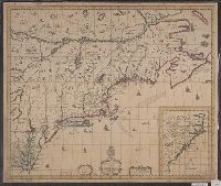
"Printed for Robt. Sayer at No. 53 in Fleet Street, London.", "Published 12th May 1794, by Laurie & Whittle, No. 53, Fleet Street, London.", "To the Right Honourable, George Dunk Earl of Halifax ...", Hand colored., Includes distance chart., and Prime meridians: L
Publisher:
Laurie & Whittle,
Subject (Geographic):
Maryland--Maps, Middle Atlantic States--Maps--Early works to 1800, and Virginia--Maps--Early works to 1800
Subject (Name):
Jefferson, Peter, 1708-1757, Jefferys, Thomas, d. 1771, Robert Laurie and James Whittle, and Sayer, Robert, 1725-1794
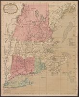
Accompanied by broadside text entitled: A description of New-England (4 p. ; 46 cm.)., Appears in author's Atlas maritimus, or, The sea-atlas, 1675., and Covers New England from the Penobscot River (Maine) region in the east to the Hudson River (New York) regio
Publisher:
And are to bee sold at his shop at the Hermitage in Wapping and by Iohn Hills in Exchange Alley in Cornhill,
Subject (Geographic):
New England--Maps--Early works to 1800
Subject (Name):
Hills, John, 17th cent and Seller, John, fl. 1658-1698. Atlas martitimus
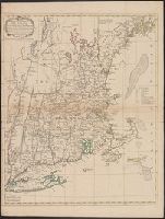
Map of Virginia, Maryland, New Jersey, New-York & New England and Mapp of New England
Description:
"Separate publication ca. 1673 ... Various dates have been assigned to the map, from 1673 to 1685" (McCorkle 33)., Inset: "A mapp of New England"., Relief shown p, and Reproduced in McCorkle, p. 33. Verso: Ink ms. annotations; numbered "57" in ink ms.
Publisher:
By John Thornton ... and by Robert Greene ... ,
Subject (Geographic):
Middle Atlantic States--Maps--Early works to 1800, New England--Maps--Early works to 1800, and New York (State)--Maps--Early works to 1800