Coahuila and Texas (Mexico). Laws, statutes, etc. 1831, Jan. 31
Published / Created:
[23 de mayo de 1831]
Call Number:
BrSide4o Zc52 831cpb
Image Count:
2
Abstract:
Reprint, with a translation into English, of decrees of the Congreso Constitucional, No. 18, September 15, 1827, relating to slavery, and No. 164, January 31, 1831, relating to the division of the Department of Bexar into two districts.
Publisher:
[Imprenta a cargo del C. Vicente de la Parra]
Subject (Geographic):
Coahuila and Texas (Mexico)
Subject (Topic):
Slavery --Law and legislation --Mexico and Slavery --Mexico --Coahuila and Texas
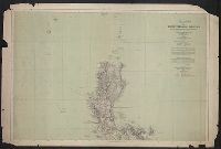
Spain. Comision hidrografica United States. Adjutant-General's Office. Military Information Division
Published / Created:
1900
Call Number:
28 1900
Container / Volume:
BRBL_00023E
Image Count:
1
Resource Type:
Maps, Atlases & Globes
Description:
[Sheet] 1, no. 59 only., In Spanish; overprinting in English., Overprinted on 1888 hydrographic chart published by the Direccion de hidrografia, Madrid., and Overprinting shows 1900 U.S. military telegraph and cable lines, Eastern Cable Company's lines, and Mili
Publisher:
Issued by the War Dept., Adjutant General's Office, Military Information Division,
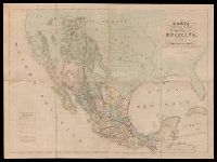
"Engraved by B.R. Davies, 16 George Str. Euston Squ., London. From the original survey made by order of the Mexican Government.", "Esta edicion se hace provicionalmente mientras se concluye la Carta en Escala mayor. Pedro Garcia Conde.", Prime meridian: Mexico City., and Relief shown by hachures.
Publisher:
s.n.,
Subject (Geographic):
Mexico--Maps and West (U.S.)--Maps
Subject (Name):
Davies, Benjamin Rees and García Conde, Pedro, 1806-1851
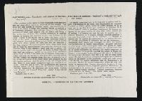
Appeal to the catholics of foreign birth in the U.S. Army to desert.
Description:
Contains parallel English and Spanish texts in double columns. and Quarto broadside.
Publisher:
Imprenta de la Caja de Ahorros
Subject (Topic):
Mexican War, 1846-1848 --Participation, Catholic, Mexican War, 1846-1848 --Participation, French, Mexican War, 1846-1848 --Participation, German, Mexican War, 1846-1848 --Participation, Irish, and Mexican War, 1846-1848 --Propaganda
" ... a modern interpretation of the 5,000 year-old quipu, which recorded the literature of the Incas on knotted cords. It ... embodies the intention and essence of a poem by Vicuña translated into English by the poet along with Jerome Rothenberg. Accompanying Chanccani Quipu is a full-color signed drawing inserted into a pamphlet entitled Instruction Manual & Orientation to Various Meanings"--Publisher description., " ... produced and published by Granary Books in an edition of 32 copies each made entirely by hand. The poem was "printed" on unspun wool using stencils made by the poet who also knotted the threads. The quipu is tied or bound to a 16 inch bamboo spine from which it hangs to about 48 inches when installed. The work is housed in a hand-stenciled box (18 1/2 x 18 1/4 x 4 inches) made by Susan Mills. Silicon Gallery Fine Art Prints in Philadelphia printed the drawing and the pamphlet in full-color. Cecilia Vicuña and Jerome Rothenberg signed the edition of 32 numbered copies"--Publisher description., and 10/32. Autographs of Cecilia Vicuña and Jerome Rothenberg. In box as issued.
Publisher:
Granary Books,
Subject (Name):
Granary Books (Firm), publisher., Mills, Susan (Susan E.), Rothenberg, Jerome, 1931-, Rothenberg, Jerome,--1931---Autograph., Silicon Gallery Fine Art Prints, printer., and Vicuña, Cecilia--Autograph.
"Constructed, projected and drawn by Fred D. Stuart, hydrographer, late of the U.S. Ex. Ex.", "Entered according to act of Congress in the 1851 by Cadwalader Ringgold ....", "Sheet no. 1.", Inset view: Entrance to San Francisco., and Place names in English and Spanish.
Publisher:
C.B. Graham, Lithr.,
Subject (Geographic):
San Francisco Bay (Calif.)--Maps and San Francisco Bay Area (Calif.)--Maps
Subject (Name):
Blunt, Simon Fraser, d. 1854, Graham, C. B. (Curtis B.), and Stuart, Fred D
"Entered according to act of Congress in the year 1851 by Cadwalader Ringgold ....", "Projected, constructed & drawn by Fred D. Stuart, hydrographer, late of the U.S. Ex. Ex. ; assisted by A.H. Campbell, civil engineer.", "Sheet no. 2.", and Inset views: Mark for invincible buoy, north extreme of Marin Is. on with clump of trees north of San Rafael -- Mark for invincible buoy, Point Smith, east end of Angel I. on with Signal Hill.
Publisher:
C.B. Graham, Lithr.,
Subject (Geographic):
San Francisco Bay (Calif.)--Maps, San Francisco Bay Area (Calif.)--Maps, and San Pablo Bay (Calif.)--Maps
Subject (Name):
Blunt, Simon F, Campbell, Albert H. (Albert Henry), 1826-1899, Graham, C. B. (Curtis B.), and Stuart, Fred D
Subject (Topic):
Nautical charts--California--San Francisco Bay and Nautical charts--California--San Pablo Bay