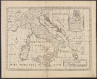
"Dedicated to His Highness William Duke of Glocester.", Appears in E. Wells' A new sett of maps both of antient and present geography., English, with Latin place names., Includes ornamental cartouche., Relief shown pictorially., and Watermarks: RDS, and fleur-de-l
Publisher:
s.n.,
Subject (Geographic):
Italy--Historical geography--Maps--Early works to 1800, Italy--History--To 476--Maps--Early works to 1800, and Rome--Maps--Early works to 1800
Subject (Name):
Nicholls, Sutton and Wells, Edward, 1667-1727. New sett of maps both of antient and present geography
A generall chart of the West Indies -- Barbados [and] Bermudos with inset: St. Michaels or the Bridge Town -- Tobago -- Antego -- St. Christophers -- A new map of the Island of Jamaica with inset: The harour [i.e., harbour] of Port Royall., Except for the general chart and the inset of St. Michaels, each map has a bar scale. The maps of Barbados, Bemudos, Tobago, Antego and St. Christophers also have latitude values. The general chart and the map of Jamaica have latitude and longitude figures in the margins., From Senex's A new general atlas ... London : Printed for Daniel Brown ..., 1721., Includes bar scales in English miles., Mounted on linen. Cross Collection no. 241., and Relief shown pictorially.
Publisher:
s.n.,
Subject (Geographic):
Jamaica--Maps--Early works to 1800 and West Indies--Maps--Early works to 1800
Subject (Name):
Harris, John, 1667?-1719, engraver and Senex, John, d. 1740. New general atlas
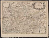
Appears in Senex's New general atlas., Cross collection no. 74., Dedicated to John Richmond Webb; dedication shows evidence of previous cartographer's name being removed and replaced by that of John Senex., London meridian., Relief shown pictorially., and Shows boundaries, rivers, forests and settlements.
Publisher:
John Senex],
Subject (Geographic):
Cambrai (France)--Maps--Early works to 1800, Hainaut (County)--Maps--Early works to 1800, and Namur (Belgium)--Maps--Early works to 1800
Subject (Name):
Senex, John, d. 1740, dedicator, Senex, John, d. 1740. New general atlas, and Webb, John Richmond, dedicatee
"Most humbly inscribed to his Royal Highness George Prince of Wales", Double hemispherical map of the world with relief shown pictorially., Mounted on stiff cardboard. Cross collection no. 30A., and Probably from Senex's A new general atlas. London: D. Browne, 1721.
From The London Magazine, 1759, v. 28., Includes list of notable locations, keyed to map., Mounted on linen. Sheet measures 13.1 x 19.5 cm. Cross Collection no. 175., Oriented with north toward upper right., and Relief shown by hachures.
Depths shown by soundings., From Gentleman's magazine, vol. 45, Jan. 1775., and In center of lower margin: Feby. 1st 1775.
Publisher:
s.n.,
Subject (Geographic):
Boston Harbor Islands Region (Mass.)--Maps--Early works to 1800, Boston Harbor Region (Mass.)--Maps--Early works to 1800, and Boston Metropolitan Area (Mass.)--Maps--Early works to 1800
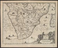
From Ogilby's Africa, being an accurate description of the regions of Egypt, Barbary, Lybia and Billedulgerid. 1670., Has watermarks., Includes ill. and decorative cartouche., and Relief shown pictorially.
Publisher:
Printed by T. Johnson for the author,
Subject (Geographic):
Africa, Sub-Saharan--Maps--Early works to 1800
Subject (Name):
Ogilby, John, 1600-1676. Africa, being an accurate description of the regions of Egypt, Barbary, Lybia and Billedulgerid
From Ogilby's Africa, being an accurate description of the regions of Egypt, Barbary, Lybia and Billedulgerid. 1670., Has watermarks., Includes ill. and decorative cartouche., and Relief shown pictorially.
Publisher:
Printed by T. Johnson for the author,
Subject (Geographic):
Africa, Central--Maps--Early works to 1800, Africa, Eastern--Maps--Early works to 1800, and Africa, North--Maps--Early works to 1800
Subject (Name):
Ogilby, John, 1600-1676. Africa, being an accurate description of the regions of Egypt, Barbary, Lybia and Billedulgerid
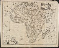
From Ogilby's Africa, being an accurate description of the regions of Egypt, Barbary, Lybia and Billedulgerid. 1670., Includes decorative title and blank dedication cartouches and ill., Relief shown pictorially., and Sheet measures 47 x 59 cm.
Publisher:
Printed by T. Johnson for the author [i.e. J. Ogilby],
Subject (Geographic):
Africa--Maps--Early works to 1800
Subject (Name):
Ogilby, John, 1600-1676. Africa, being an accurate description of the regions of Egypt, Barbary, Lybia and Billedulgerid