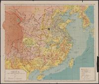
Map of China, the eighteen provinces and Shi ba sheng : [Zhongguo]
Description:
"Transliteratred by M. Kennelly, S.J. Sicawei College.", DLC, Gift of Mr. Walter J Swingle, July 23, 1952., LC copy sectioned into 2 and mounted on cloth backing., and Relief shown by gradient tints.
Publisher:
Sold at Tusewei Press,
Subject (Geographic):
China--Administrative and political divisions--Maps
Great Britain. War Office. General Staff. Geographical Section
Published / Created:
1905
Call Number:
5616 1905
Container / Volume:
BRBL_00299
Image Count:
1
Resource Type:
Maps, Atlases & Globes
Alternative Title:
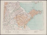
GSGS (Series) ; 1936., Province of Shandong, and T.S.G.S. ; no. 1936
Description:
Includes an English, Chinese explanation and a list of sources of information., Map of the Chinese province Shandong showing province and colonial boundaries, transportation, communications, ground and water features, missions and populated places., and Relief
Publisher:
Reproduced and printed for the Topographical Section, General Staff, at the Ordnance Survey Office,
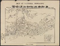
Map of Victoria, Hong Kong, Xianggang xiang xi jie dao quan tu, 最新香港詳細街道全圖 = Map of Victoria, Hong Kong., and 香港詳細街道全圖
Description:
"遊覽之必需.", In Chinese and English., Includes 1 inserted map: Xinjie quan tu., Includes 1 insertedt map: 新界全圖., and Showing streets and interesting places in Hong Kong Island.