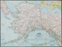
National Geographic Society (U.S.). Cartographic Division
Published / Created:
1959
Call Number:
848 1959
Container / Volume:
BRBL_00631
Image Count:
1
Resource Type:
Maps, Atlases & Globes
Alternative Title:
Atlas plate ; 18
Description:
Aleutian Islands mapping continued on inset., Includes inset on vegetation and land use., Includes insets: Vegetation and land use -- Diomede Islands., and Supplement to July, 1959 issue of the National Geographic magazine.
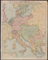
National Geographic Society (U.S.). Cartographic Division
Published / Created:
1986
Call Number:
796 1986
Container / Volume:
BRBL_00526
Image Count:
2
Resource Type:
Maps, Atlases & Globes
Alternative Title:
Making of America: Texas.
Description:
"Eleventh in a series of seventeen maps.", "Supplement to the National Geographic, March, 1986, page 310 A, vol. 169,, At head of title when folded: The making of America., Relief shown by shading and spot heights., and Text, col. ill., 6 ancillary maps on verso.
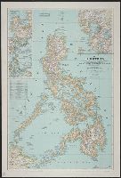
Bouma, Donald G Brehm, John J. B Darley, James M. (James Morrison) Holdstock, A. E National Geographic Society (U.S.). Cartographic Division
Published / Created:
1945
Call Number:
28 1945
Container / Volume:
BRBL_00023E
Image Count:
1
Resource Type:
Maps, Atlases & Globes
Description:
Copy 1: Mounted on linen., Insets: Location map of the Philippines. Scale 1:40,000,000 -- Lingayen, Table: Philippine provinces and their capital cities., and Topographic map with relief shown by hachures and spot heights; elevations and depths in feet.
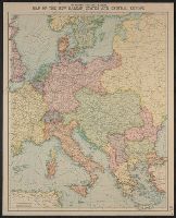
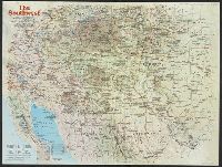
National Geographic Society (U.S.). Cartographic Division
Published / Created:
1982
Call Number:
7821 1982
Container / Volume:
BRBL_00506
Image Count:
2
Resource Type:
Maps, Atlases & Globes
Alternative Title:
Making of America, the Southwest
Description:
"Supplement to the National Geographic, November 1982, page 630A, Vol. 162, No. 5.", Relief shown by shading and spot heights., and Text, ill., and maps of early Indian occupancy, Spanish Conquest 1540-1820, Anglo-American entry and occupancy 1820-1900, and the
Publisher:
The Society,
Subject (Geographic):
America--Discovery and exploration--Spanish--Maps, Southwest, New--History--Maps, and Southwest, New--Maps
National Geographic Society (U.S.). Cartographic Division
Published / Created:
c1992.
Call Number:
739 1992
Container / Volume:
BRBL_00389
Image Count:
2
Resource Type:
Maps, Atlases & Globes
Alternative Title:
British Columbia.
Description:
"Design: Charles W. Berry ; art: Tom NcNeely ; research: Linda R. Kriete, Michael Nicolls, Andrew J. Wahll ...", Alternate title: British Columbia., Includes historical notes and inse, and Relief shown by shading and spot heights. Depths shown by gradient tints.
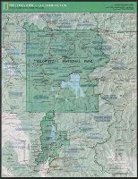
National Geographic Society (U.S.). Cartographic Division
Published / Created:
c1989.
Call Number:
833 Y38 1989
Container / Volume:
BRBL_00584
Image Count:
2
Resource Type:
Maps, Atlases & Globes
Alternative Title:
Special places of the world map series
Description:
"Supplement to the National Geographic, February 1989, page 216A, vol. 175, no.2-Yellowstone/Grand Teton.", Panel title., Relief shown by shading and spot heights., and Text, maps and col. ill. on verso.
Publisher:
The Society,
Subject (Geographic):
Grand Teton National Park (Wyo.)--Maps and Yellowstone National Park--Maps