La Pérouse, Jean-François de Galaup, comte de, 1741-1788
Published / Created:
1798
Call Number:
23 1798A
Container / Volume:
BRBL_00019
Image Count:
1
Resource Type:
Maps, Atlases & Globes
Alternative Title:
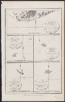
Part of the Island of Botol, Plan of Isle Dagelet, Plan of the Island Hoapinsu and the surrounding Islets, and Plan of the Island of Kumi
Description:
"No. 45.", Five maps on one sheet., From Charts and plates to La Perouse's Voyage. [London] : G.G. Robinson, 1798., Hand col. Sheet measures 42.4 x 26.5 cm., Neele, sculp., and Relief shown by spot heights, form lines, and soundings.
Pathfinder (Ship) United States. Hydrographic Office
Published / Created:
1944
Call Number:
258 1944
Container / Volume:
BRBL_00022
Image Count:
1
Resource Type:
Maps, Atlases & Globes
Alternative Title:
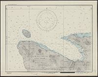
H.O. field chart ; no. 3011, H.O. field chart ; no. 3011., Malaita Island North Coast, and Suaba Harbor
Description:
"Printed May 1944, on board U.S.S. Pathfinder, for the U.S.S. Oceanographer, under authority of the Secretary of the Navy. Reprinted at the Hydrographic Office, June 1944.", "Soundings in fathoms.", and Stamped "Map and Chart Collection. Gift of Frances M., Per
Publisher:
U.S. Navy, Hydrographic Office,
Subject (Geographic):
Malaita Province (Solomon Islands)--Maps and South Pacific Ocean--Navigation--Maps
Imray, James F. (James Frederick), 1829?-1891, author James Imray and Son, publisher
Call Number:
23cea 1884
Container / Volume:
BRBL_00021
Image Count:
2
Resource Type:
Maps, Atlases & Globes
Alternative Title:
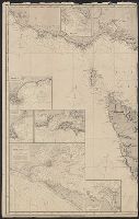
Cape Northumberland to Cape Howe and Chart no. 2, Cape Northumberland to Cape Howe
Description:
Imperfect: sheet torn in half, edges chipped, with some loss of text. Backed with paper. Manuscript annotations on map. Some locations highlighted in yellow. Label on verso: Chart and In lower left margin: Cor. VII, 83, XII, 83, 84, VII, VIII, IX.
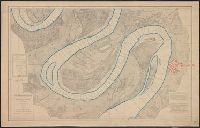
Backed with linen. River outline colored in blue; city of Greenville colored in red., Chart no. 39., Each sheet includes a list of authorities, note, and index chart.--Scale 1:360,000., Each sheet individually numbered, e.g.: Chart No.1, Chart No.2., Projected from a trigonometrical survey made in 1879-'80., and Relief shown by contours. Depths shown by soundings.
Publisher:
Mississippi River Commission,
Subject (Geographic):
Mississippi River and Mississippi River--Maps
Subject (Topic):
Nautical charts and Nautical charts--Mississippi River--Maps.
Cuba with part of the Bahama banks & the Martyrs and The North American pilot.
Description:
From: The North American pilot. London, 1778-1779. Vol. 2, no. 13., Imperfect: chipped and torn, with no loss of text. Joined with Jeffrey's Coast of Yucatán from Campeche to Baha del Ascencion, with the west end of Cuba., Prime meridians: Ferro and London., Relief shown pictorially. Depths shown by soundings and shading., and Shows towns and roads in Cuba (except easternmost and westernmost parts) and part of Bahamas and Florida Keys.
Publisher:
Printed for Robt. Sayer,
Subject (Geographic):
Bahamas--Maps--Early works to 1800, Cuba--Maps--Early works to 1800, and Florida Keys (Fla.)--Maps--Early works to 1800
Vidal, A. T. E. (Alexander Thomas Emeric), 1792-1863, author
Call Number:
655 1827
Container / Volume:
BRBL_00345
Image Count:
1
Resource Type:
Maps, Atlases & Globes
Description:
Depths shown by isolines and soundings., Manuscript annotations on verso. Manuscript number in upper left corner: 666., Prime meridian: Greenwich., and Relief shown by hachures and spot heights.
Subject (Geographic):
Atlantic Coast (Africa)--Maps and South Atlantic Ocean--Navigation
Subject (Name):
Great Britain. Hydrographic Office, publisher, J. & C. Walker (Firm), engraver, Mudge, William, 1762-1820, and Owen, W. F. W., 1774-1857
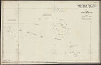
Imray, James F. (James Frederick), 1829?-1891, cartographer James Imray and Son, issuing body
Call Number:
23cea 1886
Container / Volume:
BRBL_00021
Image Count:
2
Resource Type:
Maps, Atlases & Globes
Alternative Title:
Western Pacific, sheet no. 4
Description:
Hydrographic chart of the western Pacific Ocean, including eastern Australia, Papua New Guinea, the Solomon Islands, New Hebrides, New Caledonia, and the northwest of New Zealand., Mellish Reef., and Relief shown by hachures and spot heights. Depth shown by iso
Subject (Geographic):
Melanesia--Maps and Pacific Ocean--Maps
Subject (Topic):
Nautical charts--Melanesia and Nautical charts--Pacific Ocean