C.a. travailleurs etudiants., From the Philippe Zoummeroff Collection of May 1968 Paris Counterculture., and Printed in brown ink.
Subject (Geographic):
France -- Politics and government -- 1958-1969 -- Posters
Subject (Topic):
College students -- France -- Paris -- Political activity -- Posters, General Strike, France, 1968 -- Posters, Labor movement -- France -- Paris -- Posters, Political posters, French -- France -- Paris, and Protest movements -- France -- Paris -- Posters
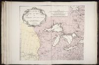
Anville, Jean Baptiste Bourguignon d', 1697-1782 Haye, G. de la
Published / Created:
Novembre 1755
Call Number:
2003 Folio 85
Image Count:
1
Description:
BEIN 2003 Folio 85: No. 3 of 45 maps bound together with binder's spine title: Atlas of America; ms. table of contents. Bookplate: Robinson. Bookplate of Paul Mellon., From the author's Atlas general. 1743-80., Hand colored., Has watermarks., National Maritime Museum. Catalog,, par le Sr. d'Anville ... ; [Gravee par] G. De-La-Haye., Relief shown pictorially., Scale [ca. 1:2,750,000]., and Sous le privilege de l'Academie.
Publisher:
Chez l'auteur, aux galeries du Louvre
Subject (Geographic):
Canada -- Maps -- Early works to 1800, Louisiana -- Maps -- Early works to 1800, and North America -- Maps -- Early works to 1800
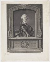
"Portrait of Charles Edward Stuart, half-length, turned to right; in armour, with insignia of the Order of the Garter; in trompe l'oeil masonry border"--British Museum online catalogue
Description:
Title from text in image., Date from British Museum online catalogue., Place of publication surmised from printmaker's place of activity., and Numbered in manuscript in lower left corner: "No 91."
Publisher:
publisher not identified
Subject (Geographic):
Great Britain.
Subject (Name):
Charles Edward, Prince, grandson of James II, King of England, 1720-1788,
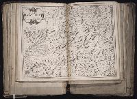
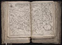
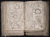
[Atlas factice of 96 maps by Blaeu, Visscher, Jansson, Hondius and others]
Image Count:
1
Description:
Imperfect: wormhole in center crease, with some loss of text. Reinforced along lower edges with manuscript waste. Sheet measures 38.8 x 51.6 cm. No. 34 of 92 maps bound together.
Publisher:
Christophe Tassin
Subject (Geographic):
Bresse (France : Region) --Maps --Early works to 1800