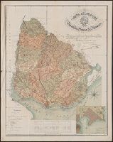
Includes table "Posición geográfico de varios puntos importantes (con relación al Meridiano de Paris)" and inset map "Vientos principales de la Bahia de Montevideo" 1:60,000. and Relief shown by shading and hachures.
Publisher:
Prudencio de Murguiondo, Consul General of the Republic of Uruguay,
Great Britain. War Office. General Staff. Geographical Section United States. Army Map Service
Published / Created:
1942
Call Number:
354 1942
Container / Volume:
BRBL_00112
Image Count:
1
Resource Type:
Maps, Atlases & Globes
Alternative Title:
[G.S.G.S.] 4327 and GSGS (Series) ; 4327.
Description:
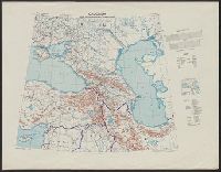
"Copied from a map produced by 512 (A. Fd. svy.) coy. R.E., January 1942 and collated by Mid-Asiatic bureau M.E.", In lower right corner of margin: Reprint November 1942., Relief shown by hachures and shading., and Two gauges of railroads, principal roads and tr
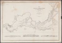
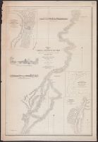
"Constructed, projected and drawn by Fred D. Stuart, hydrographer, late of the U.S. Ex. Ex. ; assisted by John Tyssowski, draughtsman., "Entered according to act of Congress in the year 1851 by Cadwalader Ringgold ....", "Sheet no. 3.", and Inset views: View of Benicia from the anchorage east of Seal Island -- Mark for Tongue Shoal -- Entrance to the Sacramento River.
Publisher:
C.B. Graham, Lithr.,
Subject (Geographic):
Sacramento River (Calif.)--Maps, San Joaquin River (Calif.)--Maps, and Suisun Bay (Calif.)--Maps
Subject (Name):
Graham, C. B. (Curtis B.), Humphreys, William P. (William Penn), Knox, Samuel R, Rowe, J. H, Stuart, Fred D, and Tyssowski, John
Subject (Topic):
Nautical charts--California--Sacramento River, Nautical charts--California--San Joaquin River, and Nautical charts--California--Suisun Bay
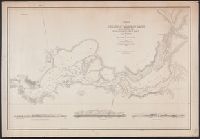
"Constructed, projected and drawn by Fred D. Stuart, hydrographer, late of the U.S. Ex. Ex.", "Entered according to act of Congress in the 1851 by Cadwalader Ringgold ....", "Sheet no. 1.", Inset view: Entrance to San Francisco., and Place names in English and Spanish.
Publisher:
C.B. Graham, Lithr.,
Subject (Geographic):
San Francisco Bay (Calif.)--Maps and San Francisco Bay Area (Calif.)--Maps
Subject (Name):
Blunt, Simon Fraser, d. 1854, Graham, C. B. (Curtis B.), and Stuart, Fred D
"Entered according to act of Congress in the year 1851 by Cadwalader Ringgold ....", "Projected, constructed & drawn by Fred D. Stuart, hydrographer, late of the U.S. Ex. Ex. ; assisted by A.H. Campbell, civil engineer.", "Sheet no. 4.", and Depths shown by soundings.
Publisher:
C.B. Graham, Lithr.,
Subject (Geographic):
Sacramento River (Calif.)--Maps
Subject (Name):
Campbell, Albert H. (Albert Henry), 1826-1899, Cullberg, Edwin, Emmet, T. A, Graham, C. B. (Curtis B.), and Stuart, Fred D