Search
You Searched For
Search Results
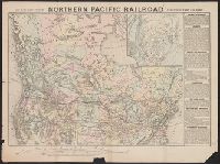
- Creator:
- National Railway Publication Company
- Published / Created:
- [1872?]
- Call Number:
- 71gme 1872
- Container / Volume:
- BRBL_00372
- Image Count:
- 1
- Resource Type:
- Maps, Atlases & Globes
- Found in:
- Beinecke Rare Book and Manuscript Library > Map of the Northern Pacific Railroad and tributary country.
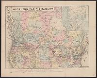
- Creator:
- National Railway Publication Company
- Call Number:
- 71gme 1870
- Container / Volume:
- BRBL_00372
- Image Count:
- 1
- Resource Type:
- Maps, Atlases & Globes
- Found in:
- Beinecke Rare Book and Manuscript Library > Map of the Northern Pacific Railway and tributary country.
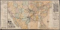
- Creator:
- Rand McNally and Company
- Published / Created:
- (Chicago : and [1886], c1883
- Call Number:
- 75gme 1883B
- Container / Volume:
- BRBL_00413
- Image Count:
- 2
- Resource Type:
- Maps, Atlases & Globes
- Found in:
- Beinecke Rare Book and Manuscript Library > Map of the South West railway system : Missouri Pacific Ry., Central Branch U.P.R.R., Missouri, Kansas & Texas Ry., Texas and Pacific Ry., St. Louis, Iron Mountn. and Southern Ry., International and Great Northern Ry. and their connections / Rand McNally
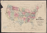
- Creator:
- Waddell, J. H. (John Hunter)
- Published / Created:
- 1868
- Call Number:
- 75GBC 1868
- Container / Volume:
- BRBL_00410
- Image Count:
- 1
- Resource Type:
- Maps, Atlases & Globes
- Found in:
- Beinecke Rare Book and Manuscript Library > Map of the United States / constructed on the rectangular tangential projection by J.H. Waddell ... ; prepared under the instructions M. F. Maury ...
- Creator:
- Waddell, J. H
- Published / Created:
- 1868?]
- Call Number:
- 75 1868
- Container / Volume:
- BRBL_00404
- Image Count:
- 1
- Resource Type:
- Maps, Atlases & Globes
- Found in:
- Beinecke Rare Book and Manuscript Library > Map of the United States / constructed on the rectangular tangential projection by J.H. Waddell ... ; prepared under the instructions M.F. Maury ...
- Creator:
- United States. General Land Office
- Published / Created:
- 1876
- Call Number:
- 75 1876
- Container / Volume:
- BRBL_00405
- Image Count:
- 6
- Resource Type:
- Maps, Atlases & Globes
- Found in:
- Beinecke Rare Book and Manuscript Library > Map of the United States and territories, showing the extent of public surveys, Indian and military reservations, land grant R.R., rail roads, canals, and other details / compiled from the official surveys of the General Land Office, and other authentic s
- Creator:
- Hutawa, Julius
- Published / Created:
- 1854?]
- Call Number:
- 75 1854A
- Container / Volume:
- BRBL_00401
- Image Count:
- 1
- Resource Type:
- Maps, Atlases & Globes
- Found in:
- Beinecke Rare Book and Manuscript Library > Map of the United States, shewing the principal steamboat routes and projected railroads connecting with St. Louis / Juls. Hutawa, lithr.
- Creator:
- Ellet, Charles, 1810-1862
- Published / Created:
- 1851
- Call Number:
- 75gme 1851
- Container / Volume:
- BRBL_00411
- Image Count:
- 1
- Resource Type:
- Maps, Atlases & Globes
- Found in:
- Beinecke Rare Book and Manuscript Library > Map of the Western Railroads tributary to Philadelphia with their rival lines / prepared under the direction of Charles Ellet Jr., civil engineer ; by W. Williams, map engraver.
- Creator:
- Tanner, Henry Schenck, 1786-1858
- Published / Created:
- 1840
- Call Number:
- 75gm 1840B
- Container / Volume:
- BRBL_00410
- Image Count:
- 1
- Resource Type:
- Maps, Atlases & Globes
- Found in:
- Beinecke Rare Book and Manuscript Library > Map of the canals & rail roads of the United States / reduced from the large map of the U.S. by H.S. Tanner ; engraved by J. Knight.
- Published / Created:
- [1857?]
- Call Number:
- 754gme 1857
- Container / Volume:
- BRBL_00419
- Image Count:
- 1
- Resource Type:
- Maps, Atlases & Globes
- Found in:
- Beinecke Rare Book and Manuscript Library > Map showing position of the Lake Erie and Pacific rail road : and its connections / [by] Chas. E. Hore, mechanical and topographical draftsman, 308 Broadway, N.Y.