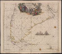
Nieuwe perfecte pascaert van t' Suyderlyckste deel van Suyt America van Rio de la Plata door de straet Magellaen tot Toral
Description:
Appears in Wit's Orbis Maritimus ofte Zee Atlas., Bar scales in "Geometrische of Duytsche Mylen ...," and "France Mylen ... miliaria Gallica.", Cross Collection no. 333., and Title in ms. on verso, with ms. no. 160.
Publisher:
Frederick de Wit,
Subject (Geographic):
Magellan, Strait of (Chile and Argentina)--Maps--Early works to 1800 and South America--Maps--Early works to 1800
Subject (Name):
Wit, Frederik de. Orbis Maritimus ofte Zee Atlas
Subject (Topic):
Coasts--South America--Maps--Early works to 1800 and Nautical charts--Magellan, Strait of (Chile and Argentina)--Maps--Early works to 1800
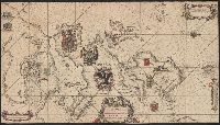
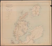
Nauigatio ac itinerarium Iohannis Hugonis Linscotani in Orientalem siue Lusitanorum Indiam
Image Count:
1
Description:
[Scale ca. 1:13,000,000]., Bound in following title page of "Descriptio totius Guineae tractus ...", In ink on top left panel of left verso: 3., and Map has several small tears now repaired on verso.
Subject (Geographic):
Africa, West --Maps --Early works to 1800
Subject (Name):
Claesz, Cornelis, ca. 1546-1609, publisher, Elzevier, Gillis, bookseller, and Hendricksz, Aelbrecht, fl. 1573-1605, printer
Subject (Topic):
Voyages and travels --Early works to 1800
Collection Created:
Hagae-Comitis : Ex officina Alberti Henrici, impensis authoris & Cornelii Nicolai, prostantque apud Aegidium Elseuirum, anno 1599
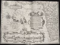
... Iohn Hvighen van Linschoten. his Discours of Voyages into ye Easte & West Indies. Deuided into
Image Count:
1
Abstract:
Engraved map depicts part of the south and west edge of Africa and also the islands of Ascension and Saint Helena within a special border.
Description:
[Scale ca. 1:13,000,000]., Bound in following title page of the second book., Map has been repaired with tape on verso., Map has black line on verso in center., Map has mirror image of brown marks on verso on bottom folded panels., and Map properly belongs to the Dutch edition of 1596.
Subject (Geographic):
Africa --Maps --Early works to 1800, Africa, West --Description and travel --Early works to 1800, Africa, West --Maps --Early works to 1800, Ascension Island (Atlantic Ocean) --Description and travel, and Saint Helena --Description and travel
Subject (Topic):
Voyages and travels --Early works to 1800
Collection Created:
Printed at London by Iohn Wolfe Printer to ye Honorable Cittie of London [1598]
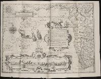
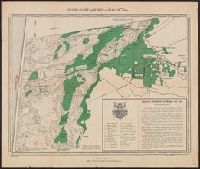
Afheeldinghe der custen des landts Guinea, Manicongo, ende Angôla, ende voorts tot voorby de C. de boa esperança and Delineatio orarum maritimarum, terrae vulgo indigetatae terra do Natal item Sofalae, Mozambicae & Melindae ...
Description:
Appears in the author's, Companion map to Delineatio orarum maritimarum, terrae vulgo indigetatae terra do Natal item Sofalae, Mozambicae & Melindae ..., Has watermark., Relief shown pictorially., and Title in Latin and Dutch. Place names in Latin and Portuguese.
Publisher:
Arnold Florent van Langren,
Subject (Geographic):
Africa, Southern--Maps--Early works to 1800
Subject (Name):
Langren, Arnold Florent van, 1580-1644 and Linschoten, Jan Huygen van, 1563-1611. Itinerario, voyage ofte schipvaert van Jan Huygen van Linschoten naer Oost ofte Portugaels Indien
Subject (Topic):
Coasts--Africa, Southern--Maps--Early works to 1800
Afheeldinghe der custen des landts Guinea, Manicongo, ende Angôla, ende voorts tot voorby de C. de boa esperança and Delineatio orarum maritimarum, terrae vulgo indigetatae terra do Natal item Sofalae, Mozambicae & Melindae ...
Description:
Appears in the author's Itinerario, voyage ofte schipvaert van Jan Huygen van Linschoten naer Oost ofte Portugaels Indien., Includes views of Ascension Island and Sain, Relief shown pictorially., and Title in Latin and Dutch. Place names in Latin and Portuguese.
Publisher:
Arnold Florent van Langren,
Subject (Geographic):
Africa, Southern--Maps--Early works to 1800
Subject (Name):
Langren, Arnold Florent van, 1580-1644 and Linschoten, Jan Huygen van, 1563-1611. Itinerario, voyage ofte schipvaert van Jan Huygen van Linschoten naer Oost ofte Portugaels Indien
Subject (Topic):
Coasts--Africa, Southern--Maps--Early works to 1800