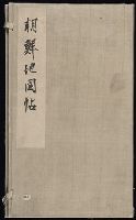
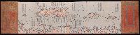
An atlas of Korea. This is an atlas of Chosŏn dynasty, and can be considered a follow-up version of the Tongguk chido (東國地圖), or the Map of Korea, drawn by Chŏng Sang-gi (鄭尚驥, 1678-1752), which has been evaluated as an outstanding accomplishment in the history of cartography. The atlas consists of a complete map of Korea, and eight maps for the provinces. The complete map of Korea is a down-scaled version in smaller size. As to the maps of each province, Kyŏnggi Province and Ch'ungch'ŏng Province were drawn in one piece, while Hamgyŏng Province, larger in area, was rendered in two pieces; northern and southern Hamgyŏng Province. A scale of one hundred ri (里) to one cha (尺) was applied and marked accurately on each of the provincial maps. The introduction of accurate scale to the map was one of the most striking features of Chŏng Sang-gi's Map of Korea. Also noteworthy are the elaborate rendering of the demarcation lines of the northern borders, and the detailed representation of the land and the sea routes, which are also the characteristics of Chŏng Sang-gi's maps. This atlas is presumed to be a copy of one that was produced before 1767 because the town names of Anŭm (安陰) and Sanŭm (山陰) of Kyŏngsang Province are given using earlier names instead of the new names adopted in that year. Other distinguishing features are that Paegyagot (白也串) in the east of Hŭngyang (興陽), Chŏlla Province is represented as an island instead of a promontory, that there is a lake near Sŏgwip'o in Cheju Island, and that the place names are marked on the northern banks across the Amnok River (鴨綠江) and Tuman River (豆滿江), which had previously been left blank. These attest to the fact that this atlas was produced or at least is a copy of one that was produced in between the original version of Chŏng Sang-gi's Map of Korea and its revised version. and 전도와8도의지도를엮음.
Alternative Title:
Chidoch'ŏp, Jido cheop, 지도첩, and 地圖帖, [Late Chosŏn i.e. 18th century].
Description:
In Korean (Hanmun)., Manuscript, in an unidentified hand., and Yale Association of Japan Collection original call number: Db11.
Subject (Topic):
Korean manuscripts and Yale Association of Japan Collection
At the beginning of the Ch'ing Dynasty (1644), the island became a defense against remnant Ming forces that had fled to Taiwan. During the second Opium War, Hai-Ta'n was occupied by British and French forces.
Publisher:
[publisher not identified],
Subject (Geographic):
Haitan Dao (China)--Maps.
Subject (Topic):
Chinese rare maps. and Islands--China--Fujian Sheng--Maps.
"Capital edition of a complete map (of the world based on) astronomy.", Ancillary maps of the world: Hai kuo wen chien lu szu hai tsung tʻu -- Nei ban shan hai tian wen quan tu., Includes notes., Relief shown pictorially., Text in Chinese, transliterated., and Woo
Institut ėtnografii imeni N.N. Miklukho-Maklai︠a︡ Институт этнографии имени Н.Н. Миклухо-Маклая
Published / Created:
1959
Call Number:
56ed 1959
Container / Volume:
BRBL_00298
Image Count:
2
Resource Type:
Maps, Atlases & Globes
Alternative Title:
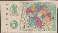
Naselenie Kitai︠a︡, MNR i Korei. and Карта народов Китая, МНР и Кореи / составлена в 1958 г. Институтом этнографии имени Н.Н. Миклухо-Маклая Академии наук СССР и Научно-редакционной картосоставительской частью ГУГК ; под общим руководством П.Е. Терлецкого ; а
Description:
Accompanied by explanatory pamphlet with title: Naselenie Kitai︠a︡, MNR i Korei by S.I. Bruk., Accompanied by explanatory pamphlet with title: Население Китая, МНР и Кореи by S.I. Bruk., Legend also in Chinese., and Title from envelope in which issued.
Publisher:
Glavnoe upravlenie geodezii i kartografii MVD SSSR :, Institut ėtnografii imeni N.N. Miklukho-Maklai︠a︡ Akademii nauk SSSR,, Главное управление геодезии и картографии МВД СССР :, and Институт этнографии имени Н.Н. Миклухо-Маклая Академии наук СССР,
Subject (Geographic):
China--Maps, Korea--Maps, and Mongolia--Maps
Subject (Name):
Bruk, Solomon Ilʹich, Soviet Union. Glavnoe upravlenie geodezii i kartografii, Soviet Union. Главное управление геодезии и картографии, Terlet︠s︡kiĭ, P. E, Брук, Соломон Ильич, and Терлецкий, П. Е
Subject (Topic):
Ethnology--China--Maps, Ethnology--Korea--Maps, and Ethnology--Mongolia--Maps
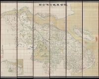
Covers all of Shandong Province and southern Hebei Province., In German and Chinese., Relief shown by shading on some sheets., and Sheets L14. and K14 only.
Publisher:
Kartogr. Abteilung der Kgl. Preuss. Landesaufnahme,
Subject (Geographic):
Beijing Region (China)--Maps, Hebei Sheng (China), Shandong Sheng (China)--Maps, and Tianjin Region (China)--Maps
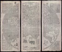
"咸豐庚申降婁海東重刊", "治理曆法極西南懷仁立法", Based on the world map of Joannes Blaeu., Includes illus. and text., Relief shown pictorially., Reprint., Shows the world in two hemispheres., and Wood block prints.
Publisher:
[publisher not identified],
Subject (Name):
Blaeu, Joan, 1596-1673.
Subject (Topic):
Chinese rare maps. and World maps--Early works to 1800.
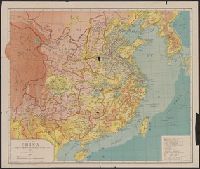
Map of China, the eighteen provinces and Shi ba sheng : [Zhongguo]
Description:
"Transliteratred by M. Kennelly, S.J. Sicawei College.", DLC, Gift of Mr. Walter J Swingle, July 23, 1952., LC copy sectioned into 2 and mounted on cloth backing., and Relief shown by gradient tints.
Publisher:
Sold at Tusewei Press,
Subject (Geographic):
China--Administrative and political divisions--Maps
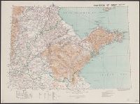
Great Britain. War Office. General Staff. Geographical Section
Published / Created:
1905
Call Number:
5616 1905
Container / Volume:
BRBL_00299
Image Count:
1
Resource Type:
Maps, Atlases & Globes
Alternative Title:
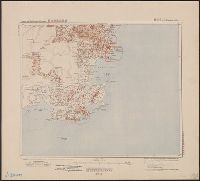
GSGS (Series) ; 1936., Province of Shandong, and T.S.G.S. ; no. 1936
Description:
Includes an English, Chinese explanation and a list of sources of information., Map of the Chinese province Shandong showing province and colonial boundaries, transportation, communications, ground and water features, missions and populated places., and Relief
Publisher:
Reproduced and printed for the Topographical Section, General Staff, at the Ordnance Survey Office,